Bapska

Bapska | |
|---|---|
 | |
| Coordinates: 45°11′50″N 19°15′45″E / 45.19722°N 19.26250°E | |
| Country | |
| County | |
| Municipality | Ilok |
| Area | |
| • Total | 26.5 km2 (10.2 sq mi) |
| Elevation | 147 m (482 ft) |
| Population (2021)[2] | |
| • Total | 658 |
| • Density | 25/km2 (64/sq mi) |
| Time zone | UTC+1 (CET) |
| • Summer (DST) | UTC+2 (CEST) |
| Postal code | 32235 Bapska |
| Area code | +385 0(32) |
Bapska (Hungarian: Bábafalva, German: Bapskau) is a village in Croatia.
Geography
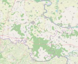
[edit]It is located south of Šarengrad (at the D2 highway) and north of Šid, Serbia.
History
[edit]In 1664 the village was raided by the Ottoman forces but was subsequently resettled.[3] The old village of Bapska was in 1730s located about two kilometres south from the contemporary village in the location know today as the Stara Bapska (Old Bapska).[3]
During the Croatian War of Independence the village became a part of the self proclaimed SAO Eastern Slavonia, Baranja and Western Syrmia. During the war special operations unit Crvene Beretke was stationed in the village where they often confronted local dissatisfaction and resistance due to their attitude towards civilian population.[4]
Demographics
[edit]| population | 1090 | 1275 | 1256 | 1447 | 1504 | 1642 | 1784 | 1752 | 1769 | 1784 | 1948 | 1944 | 1699 | 1624 | 1313 | 928 | 658 |
| 1857 | 1869 | 1880 | 1890 | 1900 | 1910 | 1921 | 1931 | 1948 | 1953 | 1961 | 1971 | 1981 | 1991 | 2001 | 2011 | 2021 |
1991 census
[edit]| Bapska[5] |
|---|
| 1991 |
total: 1,624 Croats 1,478 (91.00%) Serbs 33 (2.03%) Slovaks 28 (1.72%) Germans 25 (1.53%) Yugoslavs 16 (0.98%) Hungarians 5 (0.30%) Rusyns 5 (0.30%) Macedonians 2 (0.12%) others 1 (0.06%) nondeclared 3 (0.18%) regionally declared 1 (0.06%) unknown 27 (1.66%) |
1910 census
[edit]According to the 1910 census, settlement of Bapska had 1,642 inhabitants (in that time in two independent settlements: Bapska with pop. of 794 and Novak with pop. of 848), which were linguistically and religiously declared as this:
| Bapska[6] | |
|---|---|
| Population by language | Population by religion |
total: 1,642 Rom. Cath. 1,579 (96.16%) East. Orthodox 46 (2.80%) Calvinists 6 (0.36%) East. Catholics 6 (0.36%) Lutherans 3 (0.18%) Jewish 2 (0.12%) | |
Note: Together with former settlement of Novak.
Language
[edit]| settlement | total | Croatian | German | Slovak | Serbian | Hungarian | Slovene | Rusyn | others |
|---|---|---|---|---|---|---|---|---|---|
| Bapska | 794 | 514 | 127 | 91 | 19 | 16 | 20 | 6 | 1 |
| Novak | 848 | 549 | 221 | 24 | 25 | 25 | - | 3 | 1 |
Religion
[edit]| settlement | total | Rom. catholics | East. orthodox | Calvinists | East. catholics | Lutherans | Jewish |
|---|---|---|---|---|---|---|---|
| Bapska | 794 | 765 | 20 | 5 | 3 | 1 | - |
| Novak | 848 | 814 | 26 | 1 | 3 | 2 | 2 |
References
[edit]- ^ Register of spatial units of the State Geodetic Administration of the Republic of Croatia. Wikidata Q119585703.
- ^ "Population by Age and Sex, by Settlements" (xlsx). Census of Population, Households and Dwellings in 2021. Zagreb: Croatian Bureau of Statistics. 2022.
- ^ a b Mirko Marković (2003). Istočna Slavonija: Stanovništvo i naselja. Zagreb: Naklada Jesenski i Turk. p. 53. ISBN 9532221239.
- ^ Nikolić, Kosta (2023). Krajina: 1991.–1995 (in Serbo-Croatian). Zaprešić & Zagreb: Fraktura & Serb National Council. p. 188-189. ISBN 978-953-358-654-0.
- ^ Book: "Ethnic and religious composition of population of Croatia, 1880-1991: by settlements", author: Jakov Gelo, publisher: Zagreb, Croatian bureau of statistics, 1998., ISBN 953-6667-07-X, ISBN 978-953-6667-07-9;
- ^ Book: "Ethnic and religious composition of population of Croatia, 1880-1991: by settlements", author: Jakov Gelo, publisher: Zagreb, Croatian bureau of statistics, 1998., ISBN 953-6667-07-X, ISBN 978-953-6667-07-9;


