Beaupréau-en-Mauges

Beaupréau-en-Mauges | |
|---|---|
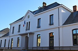
 The town hall in Beaupréau | |
| Coordinates: 47°12′10″N 0°59′36″W / 47.2028°N 0.9933°W | |
| Country | France |
| Region | Pays de la Loire |
| Department | Maine-et-Loire |
| Arrondissement | Cholet |
| Canton | Beaupréau-en-Mauges |
| Intercommunality | Mauges Communauté |
| Government | |
| • Mayor (2020–2026) | Franck Aubin[1] |
| Area 1 | 230.45 km2 (88.98 sq mi) |
| Population (2021)[2] | 23,639 |
| • Density | 100/km2 (270/sq mi) |
| Time zone | UTC+01:00 (CET) |
| • Summer (DST) | UTC+02:00 (CEST) |
| INSEE/Postal code | 49023 /49600 |
| Elevation | 32–129 m (105–423 ft) |
| 1 French Land Register data, which excludes lakes, ponds, glaciers > 1 km2 (0.386 sq mi or 247 acres) and river estuaries. | |
Beaupréau-en-Mauges (French pronunciation: [bopʁ(e)o ɑ̃ moʒ] ) is a commune in the Maine-et-Loire department in western France.
It was established on 15 December 2015 by the merger of the former communes of Andrezé, Beaupréau, La Chapelle-du-Genêt, Gesté, Jallais, La Jubaudière, Le Pin-en-Mauges, La Poitevinière, Saint-Philbert-en-Mauges and Villedieu-la-Blouère. Beaupréau is the municipal seat.[3]
Population
[edit]Graphs are unavailable due to technical issues. There is more info on Phabricator and on MediaWiki.org. |
| Year | Pop. | ±% p.a. |
|---|---|---|
| 1968 | 16,969 | — |
| 1975 | 17,989 | +0.84% |
| 1982 | 19,502 | +1.16% |
| 1990 | 20,066 | +0.36% |
| 1999 | 20,262 | +0.11% |
| 2007 | 21,296 | +0.62% |
| 2012 | 22,385 | +1.00% |
| 2017 | 23,228 | +0.74% |
| Populations of the area corresponding with the commune of Beaupréau-en-Mauges at 1 January 2020, INSEE[4] | ||
See also
[edit]References
[edit]- ^ "Répertoire national des élus: les maires" (in French). data.gouv.fr, Plateforme ouverte des données publiques françaises. 13 September 2022.
- ^ "Populations légales 2021" (in French). The National Institute of Statistics and Economic Studies. 28 December 2023.
- ^ Recueil des actes administratifs du 30 septembre 2015 Archived 4 March 2016 at the Wayback Machine, prefecture Maine-et-Loire
- ^ Population en historique depuis 1968, INSEE


