Hastings Tract

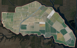
 USGS aerial imagery of Hastings Tract | |
| Geography | |
|---|---|
| Location | Northern California |
| Coordinates | 38°16′19″N 121°43′45″W / 38.27194°N 121.72917°W[1] |
| Adjacent to | Sacramento–San Joaquin River Delta |
| Area | 6,400 acres (2,600 ha)[2] |
| Highest elevation | 0 ft (0 m)[1] |
| Administration | |
United States | |
| State | |
| County | Solano |

The Hastings Tract is an island in the Sacramento–San Joaquin River Delta.[3][4][5][6] It is part of Solano County, California, and managed by Reclamation District 2060.[7] Its coordinates are 38°16′19″N 121°43′45″W / 38.27194°N 121.72917°W[1], and the United States Geological Survey measured its elevation as 0 ft (0 m) in 1981.[1]
References
[edit]- ^ a b c d U.S. Geological Survey Geographic Names Information System: Hastings Tract
- ^ "State, North Delta Agency Directors Agree On Price For Water Deliveries". The Sacramento Bee. Sacramento, California. 1980-01-19. p. 1.
- ^ "On the Eighteenth day of May, 1858". The Daily Bee. Sacramento, California. 1858-04-28. p. 2.
- ^ "Fishing Line". The Sacramento Bee. Sacramento, California. 2003-12-24. p. C6.
- ^ "Those Hastings Were A Busy Lot". Oakland Tribune. Oakland, California. 1972-11-19. p. 141.
- ^ "4,700 Acre Tract In Delta Is Sold". The Sacramento Bee. Sacramento, California. 1961-08-10. p. 29.
- ^ "Municipal Service Review: Solano County Water, Irrigation, Reclamation, and Flood Management Agencies" (PDF). Solano County LAFCO. Michael Brandman Associates. 13 April 2009. Archived (PDF) from the original on 14 March 2021. Retrieved 25 February 2021.


