José Miguel de Velasco Province

José Miguel de Velasco | |
|---|---|
Province | |
 | |
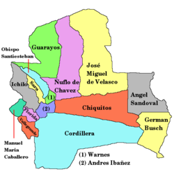
 Location of the José Miguel de Velasco Province within Bolivia | |
 Provinces of the Santa Cruz Department | |
| Coordinates: 15°30′0″S 61°0′0″W / 15.50000°S 61.00000°W | |
| Country | |
| Department | Santa Cruz Department |
| Capital | San Ignacio de Velasco |
| Area | |
| • Total | 25,261 sq mi (65,425 km2) |
| Elevation | 1,329 ft (405 m) |
| Population (2024 census)[1] | |
| • Total | 91,573 |
| • Density | 3.6/sq mi (1.4/km2) |
| Website | www.santacruz.gob.bo |
José Miguel de Velasco or Velasco is a province in the Santa Cruz department of Bolivia. Its capital is San Ignacio de Velasco. The province is named after the Bolivian president José Miguel de Velasco Franco. It was created by law on October 12, 1880, during the presidency of Narciso Campero. Until its creation it was integrated into Chiquitos Province.[2]
Geography
[edit]Velasco is located between the major Bolivian city of Santa Cruz de la Sierra and the Brazilian border. An unpaved highway connects the province with the city of Santa Cruz to the west and Brazil to the east.[3]
Subdivision
[edit]José Miguel de Velasco Province is divided into three municipalities which are further subdivided into cantons.
| Section | Municipality | Inhabitants (2001) [4] | Seat | Inhabitants (2001) |
|---|---|---|---|---|
| 1st | San Ignacio de Velasco Municipality | 41,412 | San Ignacio de Velasco | 19,401 |
| 2nd | San Miguel Municipality | 10,273 | San Miguel de Velasco | 4,484 |
| 3rd | San Rafael Municipality | 5,017 | San Rafael de Velasco | 2,057 |
Towns in the province include Santa Ana de Velasco.
Culture
[edit]Velasco features a mestizo culture, blending the culture of the Spanish conquistadors and missionaries with those of the indigenous peoples. Spanish is the most commonly used language in public, though indigenous languages, such as Chiquitano, are also used. Due to the proximity of the province to Brazil, Portuguese speakers can be found, particularly merchants in the city of San Ignacio. There is a small presence of Mennonites and descendants of post-World War II German immigrants.
Places of interest
[edit]Gallery
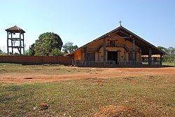
[edit]- San Rafael de Velasco mission church
- San Miguel de Velasco mission church
- Santa Ana de Velasco mission church
- View of San Ignacio de Velasco town
See also
[edit]References
[edit]- ^ "Bolivia: Administrative divisions". City Population. Retrieved 11 September 2024.
- ^ Official site of José Miguel de Velasco Province (Spanish)
- ^ Guia Turistica de la Provincia "Velasco", Gobierno Municipal de San Ignacio de Velasco, 1996
- ^ National Institute of Statistics, Bolivia Archived 2011-09-24 at the Wayback Machine (Spanish)
External links
[edit]15°30′00″S 61°00′00″W / 15.500°S 61.000°W


