Kara-Suu District

Kara-Suu Kyrgyz: Кара-Суу району | |
|---|---|
 | |
 | |
| Country | Kyrgyzstan |
| Region | Osh Region |
| Area | |
| • Total | 3,616 km2 (1,396 sq mi) |
| Population (2021)[1] | |
| • Total | 448,608 |
| • Density | 120/km2 (320/sq mi) |
| Time zone | UTC+6 |
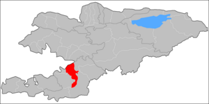
Kara-Suu (Kyrgyz: Кара-Суу району, romanized: Kara-Suu rayonu) is a district of Osh Region in south-western Kyrgyzstan. Its area is 3,616 square kilometres (1,396 sq mi),[2] and its resident population was 448,608 in 2021.[1] The administrative seat lies at the city Kara-Suu.[3]
Population
[edit]The district has a sizeable Uzbek minority (38.5% in 2009).[2]
| Year | Pop. | ±% p.a. |
|---|---|---|
| 1970 | 134,832 | — |
| 1979 | 172,752 | +2.79% |
| 1989 | 217,575 | +2.33% |
| 1999 | 294,043 | +3.06% |
| 2009 | 348,645 | +1.72% |
| 2021 | 448,608 | +2.12% |
| Note: resident population; Sources:[2][1] | ||
Towns, rural communities and villages
[edit]In total, Kara-Suu District include 1 city and 137 settlements in 16 rural communities (ayyl aymagy). Each rural community can consist of one or several villages. The rural communities and settlements in the Kara-Suu District are:[3]
- town Kara-Suu
- Ak-Tash (seat: Ak-Tash; incl. Jylkeldi and Barak)
- Jangy-Aryk (seat: Jangy-Aryk; incl. Ak-Terek, Pravda and Tash-Aryk)
- Joosh (seat: Bolshevik; incl. Agartuu, Gayrat, Zarbalyk, Kalinin, Kommunizm, Kyzyl-Koshchu, Kyzyl-Saray, Madaniyat, Mamajan and Pitomnik)
- Kashgar-Kyshtak (seat: Kashgar-Kyshtak; incl. Alga-Bas, Anjyyan-Maala, Bek-Jar, Jar-Ooz, Kenjekul, Tajik-Maala and Monok)
- Katta-Taldyk (seat: Bash-Bulak; incl. Jangy-Turmush, Kara-Sögöt, Taldyk, Kichik, Kyzyl-Ordo, Sadyrbay, Eshme, Achy and Torgoy-Bulak)
- Kyzyl-Kyshtak (seat: Kyzyl-Kyshtak; incl. Anjyyan, Bel-Kyshtak, Jangy-Kyshtak, Karl Marks, Kommunist and Kyzyl-Bayrak)
- Kyzyl-Suu (seat: Chaychy; incl. Ak-Jar, Korgon, Miyaly, Alpordo, Talaa and Uchkun)
- Mady (seat: Kyrgyz-Chek; incl. Asanchek, Joosh, Kaarman, Laglan, Mady, Oktyabr, Sotsializm, Teeke, Uchkun and Chagyr)
- Nariman (seat: Nariman; incl. Alim-Tepe, Besh-Moynok, VLKSM, Jangy-Maala, Jiydalik, Karatay, Osmon, Kurankol, Kyzyl-Mekhnat, Langar, Nurdar, Jim and Tajikabad)
- Otuz-Adyr (seat: Otuz-Adyr; incl. Kara-Döbö, Kyzyl-Abad, Kysh-Abad, Savay-Aryk, Furkhat, Yntymak, Jangy-Kyzyl-Suu and Tynchtyk)
- Papan (seat: Papan; incl. Ak-Terek, Alchaly, Ata-Merek, Börü, Karagur, Kojo-Keleng, Kyzyl-Tuu, Toguz-Bulak, Ak-Buura-1, Ak-Buura-2, Ak-Buura-3, Ak-Buura-4, Kamyr-Suu, Jar-Bashy, Chychkan-Kol, Andagul and Jany-Turmush)
- Sary-Kolot (seat: Sary-Kolot; incl. Ak-Kolot, Kurban-Kara, Sheraly, Prisavay and Tynchtyk)
- Saray (seat: Kirov; incl. Erkin, Prisavay, Kongurat, Telman and Ak-Orgoo)
- Savay (seat: Kyzyl-Shark; incl. Keng-Say, Köchkön-Jar, Kurban-Kara, Kydyrsha, Oktyabr, Yntymak, Savay and Sultan-Abad)
- Shark (seat: Shark; incl. Tashtak, Imam-Ata, Madaniyat, Top-Terek, Furkat and Medrese)
- Tölöykön (seat: Dyykan-Kyshtak; incl. Kyrgyzstan, Özgür, Tölöykön, Uchar, Bodur-Tash and Japalak)

Agartuu
Koshchu
Saray
Achy
Moynok
Kyzyl-
Mekhnat
Abad
Savay-Aryk
Kyzyl-
Suu
Buura-3
Kara
References
[edit]- ^ a b c "Population of regions, districts, towns, urban-type settlements, rural communities and villages of Kyrgyz Republic" (XLS) (in Russian). National Statistics Committee of the Kyrgyz Republic. 2021. Archived from the original on 10 November 2021.
- ^ a b c "2009 population and housing census of the Kyrgyz Republic: Osh Region" (PDF) (in Russian). National Statistics Committee of the Kyrgyz Republic. 2010. pp. 12, 17, 53.
- ^ a b "Classification system of territorial units of the Kyrgyz Republic" (in Kyrgyz). National Statistics Committee of the Kyrgyz Republic. May 2021. pp. 50–54.
