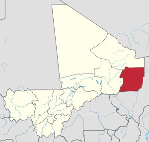
Ménaka Region

Ménaka | |
|---|---|
 Location of the former Ménaka Cercle in Mali, corresponding to the current region | |
 Interactive map of Ménaka Region in Mali | |
| Coordinates: 16°42′N 2°42′E / 16.7°N 2.7°E | |
| Country | |
| Capital | Ménaka |
| Government | |
| • Governor | Daouda Maïga |
| Area | |
| • Total | 81,040 km2 (31,290 sq mi) |
| Population (2009 census)[2] | |
| • Total | 54,456 |
| • Density | 0.67/km2 (1.7/sq mi) |
| Time zone | UTC±0 (UTC) |
Ménaka (Bambara: ߡߋߣߊߞߊ ߘߌߣߋߖߊ tr. Menaka Dineja) is a region of Mali legislatively created in 2012 from the cercle of the same name previously part of Gao Region.[3][4] Actual implementation of the region began on 19 January 2016 with the appointment of Daouda Maïga as the region's governor.[5][6] Members of the region's transitional council were appointed on 14 October 2016.[7] The region is divided into four cercles: Andéramboukane, Inékar, Tidermène, and Ménaka, the location of the capital, also called Ménaka.[5]
References
[edit]- ^ Brinkhoff, Thomas. "Mali: Administrative Division". City Population. Retrieved 21 February 2017.
- ^ SERIE DEMOGRAPHIQUE (PDF). 4ème RECENSEMENT GENERAL DE LA POPULATION ET DE L’HABITAT DU MALI (RGPH): RESULTATS DEFINITIFS (Report). Vol. 1. INSTAT. November 2011. p. 5. Retrieved 21 February 2017.
- ^ "LOI No 2012-017 DU 02 MARS 2012 PORTANT CREATION DE CIRCONSCRIPTIONS ADMINISTRATIVES EN REPUBLIQUE DU MALI" (PDF). Journal officiel de la République du Mali. 2 March 2012. p. 364. Retrieved 21 February 2017.
- ^ "Report of the Secretary-General on the situation in Mali" (PDF). MINUSMA. 28 March 2016. Retrieved 21 February 2017.
- ^ a b "Régionalisation: Deux Nouvelles régions créées au Mali". Malijet. 21 January 2016. Retrieved 21 February 2017.
- ^ "Nomination: Ménaka fête déjà son Gouverneur". Maliweb. 30 January 2016. Retrieved 21 February 2017.
- ^ "Report of the Secretary-General on the situation in Mali" (PDF). MINUSMA. 30 December 2016. Retrieved 21 February 2017.