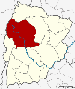
Nong Bua Daeng district

Nong Bua Daeng หนองบัวแดง | |
|---|---|
 District location in Chaiyaphum province | |
| Coordinates: 16°4′54″N 101°48′12″E / 16.08167°N 101.80333°E | |
| Country | Thailand |
| Province | Chaiyaphum |
| Seat | Nong Bua Daeng |
| Area | |
| • Total | 2,215.5 km2 (855.4 sq mi) |
| Population (2000) | |
| • Total | 92,766 |
| • Density | 41.9/km2 (109/sq mi) |
| Time zone | UTC+7 (ICT) |
| Postal code | 36210 |
| Geocode | 3605 |
Nong Bua Daeng (Thai: หนองบัวแดง, pronounced [nɔ̌ːŋ būa̯ dɛ̄ːŋ]) is a district (amphoe) of Chaiyaphum province, northeastern Thailand.
History
[edit]The district was established as a minor district (king amphoe) on 16 July 1965, when the two tambons Nong Bua Daeng and Nang Daet were split off from Kaset Sombun District.[1] It was upgraded to a full district on 1 April 1969.[2]
Geography
[edit]Neighbouring districts are (from the north clockwise): Khon San district, Kaset Sombun, Mueang Chaiyaphum, Ban Khwao, Nong Bua Rawe, and Phakdi Chumphon of Chaiyaphum Province; and Nong Phai and Mueang Phetchabun of Phetchabun province.
Administration
[edit]The district is divided into eight subdistricts (tambons), which are further subdivided into 130 villages (mubans). There is one municipality (thesaban), and eight tambon administrative organizations (TAO).
| 1. | Nong Bua Daeng | หนองบัวแดง | |
| 2. | Kut Chum Saeng | กุดชุมแสง | |
| 3. | Tham Wua Daeng | ถ้ำวัวแดง | |
| 4. | Nang Daet | นางแดด | |
| 7. | Nong Waeng | หนองแวง | |
| 8. | Khu Mueang | คูเมือง | |
| 9. | Tha Yai | ท่าใหญ่ | |
| 11. | Wang Chomphu | วังชมภู |
Missing numbers are now tambons of Phakdi Chumphon District.
References
[edit]- ^ ประกาศกระทรวงมหาดไทย เรื่อง แบ่งท้องที่ตั้งเป็นกิ่งอำเภอ (PDF). Royal Gazette (in Thai). 82 (57 ง): 1878. July 20, 1965. Archived from the original (PDF) on May 10, 2012.
- ^ พระราชกฤษฎีกาจัดตั้งอำเภอสมเด็จ อำเภอสีชมพู อำเภอหนองบัวแดง อำเภอบ้านแท่น อำเภอดอนตูม อำเภอนากลาง อำเภอศรีบุญเรือง และอำเภอป่าติ้ว พ.ศ. ๒๕๑๒ (PDF). Royal Gazette (in Thai). 86 (16 ก): 225–229. February 25, 1969. Archived from the original (PDF) on March 24, 2012.
External links
[edit]