Samarina

Samarina Σαμαρίνα | |
|---|---|
 Panoramic view | |
| Coordinates: 40°6′N 21°4′E / 40.100°N 21.067°E | |
| Country | Greece |
| Administrative region | Western Macedonia |
| Regional unit | Grevena |
| Municipality | Grevena |
| Area | |
| • Municipal unit | 97.245 km2 (37.547 sq mi) |
| Elevation | 1,450 m (4,760 ft) |
| Population (2021)[1] | |
| • Municipal unit | 253 |
| • Municipal unit density | 2.6/km2 (6.7/sq mi) |
| Time zone | UTC+2 (EET) |
| • Summer (DST) | UTC+3 (EEST) |
| Postal code | 511 00 |
| Area code(s) | 24620 |
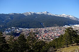
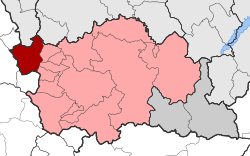
Samarina (Greek: Σαμαρίνα, Aromanian: Samarina, Xamarina, San Marina) is a village and a former municipality in Grevena regional unit, West Macedonia, Greece. Since the 2011 local government reform it is part of the municipality Grevena, of which it is a municipal unit.[2] Its population primarily consists of Aromanians (Vlachs).[3][4][5] The population was 253 people as of 2021.[1] It attracts many tourists due to its scenic location and beautiful pine and beech forests. The municipal unit has an area of 97.245 km2 (37½ sq. mi.).[6]
Samarina is the most famous of all the Aromanian villages of the Pindus and the inhabitants are fiercely proud of their heritage and traditions. Every summer on August 15, on the feast.
Location
[edit]Samarina is located on an eastern spur of Mount Smolikas, the highest of the Pindus range and the second-highest mountain in all of Greece. At an altitude of 1380–1515 meters (4528' to 4970'), it is considered one of the highest villages in Greece and also one of the highest in the Balkans; its height puts it among soaring settlements such as: Aetomilitsa (Densko) and Seli (Selia).
Climate
[edit]Samarina has a warm-summer humid continental climate (Köppen climate classification: Dfb) using the 0 °C (32 °F) isotherm, or a temperate oceanic climate (Köppen climate classification: Cfb) using the -3 °C (27 °F) isotherm for the coldest month. Samarina experiences cold winters with high precipitation and warm, drier summers.
| Climate data for Samarina | |||||||||||||
|---|---|---|---|---|---|---|---|---|---|---|---|---|---|
| Month | Jan | Feb | Mar | Apr | May | Jun | Jul | Aug | Sep | Oct | Nov | Dec | Year |
| Mean daily maximum °C (°F) | 0.52 (32.94) | 3.03 (37.45) | 7.13 (44.83) | 11.08 (51.94) | 16.84 (62.31) | 21.14 (70.05) | 25.05 (77.09) | 25.10 (77.18) | 21.82 (71.28) | 15.16 (59.29) | 7.84 (46.11) | 2.81 (37.06) | 13.13 (55.63) |
| Daily mean °C (°F) | −2.66 (27.21) | −0.97 (30.25) | 2.11 (35.80) | 7.01 (44.62) | 12.07 (53.73) | 16.37 (61.47) | 19.51 (67.12) | 19.43 (66.97) | 14.62 (58.32) | 9.22 (48.60) | 3.24 (37.83) | 0.24 (32.43) | 8.35 (47.03) |
| Mean daily minimum °C (°F) | −5.30 (22.46) | −3.30 (26.06) | −1.30 (29.66) | 1.99 (35.58) | 4.31 (39.76) | 8.29 (46.92) | 10.78 (51.40) | 10.52 (50.94) | 6.01 (42.82) | 2.12 (35.82) | −0.39 (31.30) | −3.31 (26.04) | 2.53 (36.56) |
| Average precipitation mm (inches) | 267.55 (10.53) | 300.39 (11.83) | 217.18 (8.55) | 174.16 (6.86) | 123.98 (4.88) | 77.84 (3.06) | 69.90 (2.75) | 70.89 (2.79) | 77.1 (3.04) | 164.54 (6.48) | 283.58 (11.16) | 365.24 (14.38) | 2,192.35 (86.31) |
| Mean monthly sunshine hours | 99.19 | 125.85 | 141.21 | 164.69 | 212.79 | 275.24 | 288.62 | 252.93 | 189.78 | 150.20 | 101.84 | 78.98 | 2,081.32 |
| Source: Hellenic National Meteorological Service[7] | |||||||||||||
History
[edit]This village in the Pindos mountains with its Aromanian population enjoyed successful periods of exceptional economic growth and cultural development. On a map it was shown under the name Santa Marina. Its inhabitants tended sheep and goats and wove a woolen fabric called flokati ('nflucati, velentza), which they sold at the region's trade fairs. The people of Samarina were also involved in trade, and as muleteers they pioneered long caravans that traveled all over the Balkans. The level of culture reached by this town (it had churches, schools and a library) is evident in the excellence of its religious painting. Samarina flourished at the end of the 18th century and during the 19th. The economic success was based on a group of activities, but mostly in the cattle-breeding, the small industries, the trade and the arts.
An important account of the life of the Aromanian population of Samarina at the beginning of the 20th century is provided in a study by A.J.B. Wace and M.S. Thompson entitled Nomads of the Balkans: an account of life and customs among the Vlachs of Northern Pindus, London 1914.
The Greek folklore song "Children of Samarina" (Greek: Παιδιά απ'την Σαμαρίνα) is associated with it. It refers to local volunteers who fought and lost their lives during the Greek War of Independence against the Turks in 1821. In particular, it refers to the Messolonghi events and the heroic "Exodus of its Guards".
Samarina was the birthplace of Alcibiades Diamandi and Nicolaos Matussis, leaders of the Roman Legion, who promoted a local autonomous Aromanian nationalist canton during World War II called in some cases the Principality of Pindus (this name is mainly used for the events of 1917 in Samarina). It was also where the revolutionary Ioannis Arkoudas came from.
Notable people
[edit]- Zicu Araia (1877–1948), poet, schoolteacher and Aromanian separatist
- Alcibiades Diamandi (1893–1948), entrepreneur, politician and Aromanian separatist
- Nicolaos Matussis (1899–1991), lawyer, politician and Aromanian separatist
- Jiří Staca (1884–1958), philologist and translator
Furthermore, the father of the Greek Aromanian communist politician Andreas Tzimas was from Samarina; Tzimas' nom de guerre was Vasilis Samariniotis.
Notes
[edit]- ^ a b "Αποτελέσματα Απογραφής Πληθυσμού - Κατοικιών 2021, Μόνιμος Πληθυσμός κατά οικισμό" [Results of the 2021 Population - Housing Census, Permanent population by settlement] (in Greek). Hellenic Statistical Authority. 29 March 2024.
- ^ "ΦΕΚ B 1292/2010, Kallikratis reform municipalities" (in Greek). Government Gazette.
- ^ Chang, Claudia (1993). "Pastoral Transhumance in the Southern Balkans as a Social Ideology: Ethnoarcheological Research in Northern Greece". American Anthropologist. 95 (3): 691. "Vlachohoria, or the four famous Koutsovlach villages of Grevena–Samarina, Perivoli, Avdella, and Smixi–are described as the summer villages of the Koutsovlach, where Aroumani is spoken."
- ^ Ntassiou, Konstantina; Doukas, Ioannis D. (2019). "Recording and mapping traditional transhumance routes in the South-Western Macedonia, Greece". GeoJournal. 84 (1): 165. "The four Vlach villages of Grevena (Perivoli, Avdella, Smixi, Samarina)"
- ^ Biagi, Paolo; Starnini, Elisabetta; Efstratiou, Nikos; Nisbet, Renato; Hughes, Philip D.; Woodward, Jamie C. (2022). "Mountain landscape and human settlement in the Pindus Range: The Samarina highland zones of Western Macedonia, Greece". Land. 12 (1): 1. "the Vlach town of Samarina"
- ^ "Population & housing census 2001 (incl. area and average elevation)" (PDF) (in Greek). National Statistical Service of Greece.
- ^ "Aetomilitsa Climatic Data". Hellenic National Meteorological Service. Retrieved 14 March 2021.

