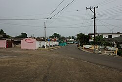
Taguasco

This article needs additional citations for verification. (February 2024) |
Taguasco | |
|---|---|
 | |
 Taguasco municipality (red) within Sancti Spíritus Province (yellow) and Cuba | |
| Coordinates: 22°00′18″N 79°15′54″W / 22.00500°N 79.26500°W | |
| Country | Cuba |
| Province | Sancti Spíritus |
| Area | |
| • Total | 518 km2 (200 sq mi) |
| Elevation | 100 m (300 ft) |
| Population (2022)[2] | |
| • Total | 32,968 |
| • Density | 64/km2 (160/sq mi) |
| Time zone | UTC-5 (EST) |
| Area code | +53-41 |
| Website | https://taguasco.gob.cu/ |
Taguasco (Spanish pronunciation: [taˈɣwasko]) is a municipality and town in the Sancti Spíritus Province of Cuba.
Geography
[edit]It is located 20 kilometres (12 mi) north-east of Sancti Spiritus, the provincial capital, and is bisected by Carretera Central highway between Cabaiguán and Jatibonico.
Demographics
[edit]In 2022, the municipality of Taguasco had a population of 32,968.[2] With a total area of 518 km2 (200 sq mi),[1] it has a population density of 64/km2 (170/sq mi).
See also
[edit]References
[edit]- ^ a b Statoids (July 2003). "Municipios of Cuba". Retrieved 2007-10-07.
- ^ a b "Cuba: Administrative Division (Provinces and Municipalities) - Population Statistics, Charts and Map". www.citypopulation.de. Retrieved 2024-02-03.
External links
[edit]![]() Media related to Taguasco at Wikimedia Commons
Media related to Taguasco at Wikimedia Commons