Файл:PIA24167 Hazard Map for Jezero.jpg


Исходный файл (984 × 801 пкс, размер файла: 149 КБ, MIME-тип: image/jpeg)
Этот файл находится на Викискладе. Сведения о нём показаны ниже. Викисклад — централизованное хранилище для свободных файлов, используемых в проектах Викимедиа. |
Краткое описание
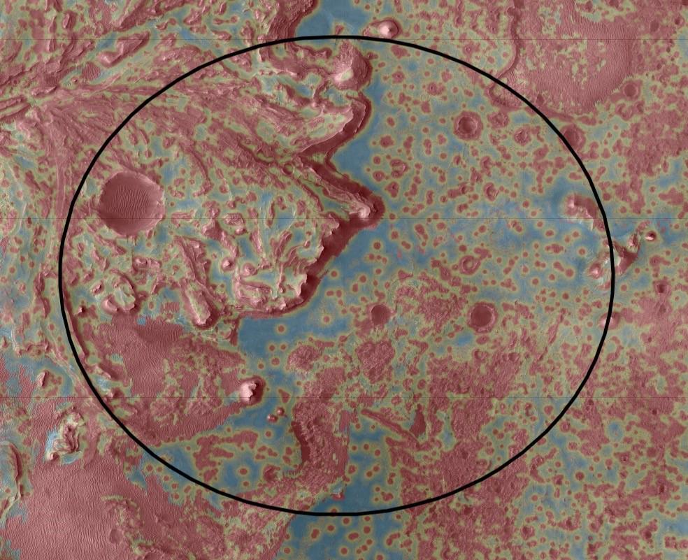
| Описание | English: The Mars 2020 Perseverance rover will rely on data depicted in this Hazard Map to help guide it to a safe landing. Landing hazards are depicted in red; safer areas are colored blue and green. To select the best location to touch down while avoiding damage to the rover, the spacecraft's Terrain-Relative Navigation system will take images of the terrain below as Perseverance descends through the atmosphere. Computers aboard the rover will then compare these images with its onboard map — the best ever created for a space mission — and adjust course as needed. Terrain-Relative Navigation has enabled the mission to select Jezero Crater as its landing site. Scientists believe an ancient river flowed into a lake there and deposited sediments in a fan shape known as a delta. Such an environment was likely to have preserved signs of any life that gained a foothold billions of years ago. But while the region has high astrobiological potential, it is also very hazardous, with dunes, cliffs and boulder-strewn areas that pose a huge challenge for landing. NASA's Jet Propulsion Laboratory in Southern California built and manages operations of the Mars 2020 Perseverance rover for NASA. Image Credit: NASA/JPL-Caltech |
| Дата | |
| Источник | https://photojournal.jpl.nasa.gov/jpeg/PIA24167.jpg |
| Автор | NASA |
Это изображение или видеозапись внесены в каталог Лаборатории реактивного движения НАСА под идентификатором (Photo ID): PIA24167. Этот шаблон не указывает на правовой статус данной работы. По-прежнему необходим нормальный шаблон лицензий. См. Commons:Лицензирование. Другие языки:
|
Лицензирование
| Этот файл находится в общественном достоянии (англ. public domain), так как он был создан NASA (Национальным управлением по аэронавтике и исследованию космического пространства). Политика авторского права NASA гласит, что «Материал NASA не защищается авторским правом, если не указано иное». (См. Template:PD-USGov, страницу политики авторского права NASA или политику использования изображений JPL.) | ||
 | Предупреждения:
|
История файла
Нажмите на дату/время, чтобы посмотреть файл, который был загружен в тот момент.
| Дата/время | Миниатюра | Размеры | Участник | Примечание | |
|---|---|---|---|---|---|
| текущий | 10:43, 19 июля 2021 | | 984 × 801 (149 КБ) | Cherurbino | Uploaded a work by NASA from https://photojournal.jpl.nasa.gov/jpeg/PIA24167.jpg with UploadWizard |
Использование файла
Следующие 3 страницы используют этот файл: