Файл:Reichskanzlei-Vorbunker.png


Исходный файл (1607 × 3514 пкс, размер файла: 356 КБ, MIME-тип: image/png)
Этот файл находится на Викискладе. Сведения о нём показаны ниже. Викисклад — централизованное хранилище для свободных файлов, используемых в проектах Викимедиа. |
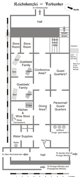
| Описание | Map of the Vorbunker in Berlin, 1945. |
| Дата | |
| Источник | Собственная работа |
| Автор | User:Dna-Dennis |
| Права (Повторное использование этого файла) | CC, see below. The map is completely unrestricted for any Wikipedia/Wikimedia project. |
Лицензирование
- Вы можете свободно:
- делиться произведением – копировать, распространять и передавать данное произведение
- создавать производные – переделывать данное произведение
- При соблюдении следующих условий:
- атрибуция – Вы должны указать авторство, предоставить ссылку на лицензию и указать, внёс ли автор какие-либо изменения. Это можно сделать любым разумным способом, но не создавая впечатление, что лицензиат поддерживает вас или использование вами данного произведения.
Краткое описание
This is a map of the Vorbunker in Berlin, 1945 - the "antechamber" bunker of the famous Fuehrerbunker. The layout is not necessarily perfectly exact, but it is very probable. There were two bunkers which were connected - the Fuehrerbunker and the Vorbunker, and here is the link to my map of the Fuehrerbunker, and a link to my map showing the locations of the Fuehrerbunker and Vorbunker in Berlin, 1945.
Information about the details of the bunkers is rather scarce, which is not strange, since the bunkers were secret. This map is based on the excellent research of Tom Posch (see below), who visited and photographed the remains from inside in 1988. He concluded that the map of the bunker in Cornelius Ryan's The Last Battle was incorrect, and a new, hand-drawn map of the Vorbunker was produced by Tom Posch.
Location notes
The Fuehrerbunker, built in 1944, was located 8-17 meters beneath the Reichskanzlei garden, approx. 120 meters north of the new Reichskanzlei building, which had the address Vossstrasse 6. The Führerbunker was located somewhat lower than the Vorbunker and west (or rather west-west-south) of it. The two bunkers were connected via sets of stairs set at right angles (not spiral).
Layout notes
- Particularly uncertain items are marked with question marks.
- The exact position of water & ventilation facilites and showers are uncertain.
Construction data (approximates)
- Material: Concrete
- Protective Wall Width: 220 cm
- Protective Roof Height: 280 cm
- Wall Width (interior): 15-20 cm
- Door Heights: 180-200 cm
- Door Widths: 120 cm
- Room Heights: 2-3 m
- Room Sizes: Varying; 3-5 m
References
The map is based on the following sources:
- Ramsey, Winston G. (editor) & Posch, Tom (researcher), The Berlin Führerbunker: The Thirteenth Hole, After the Battle archive copy at the Wayback Machine, No.61, Special Edition, Battle of Britain International Ltd, 1988, London
- Allied Intelligence Map of Key Buildings in Berlin (3rd edition, 1945)
- Ryan, Cornelius, The Last Battle (1966)
Regards, Dennis Nilsson, Sweden.
If you wish to contact me, please leave a message on my talk page.
 | Это изображение неизвестного типа «architecture» желательно воссоздать или аккуратно преобразовать в векторный формат SVG. Это даёт несколько преимуществ, прочитать о которых подробнее вы можете на странице Commons:Media for cleanup. Если вам уже сейчас доступна векторная версия данного изображения, загрузите её, пожалуйста, а затем замените этот шаблон на следующий: {{Vector version available|Имя загруженного файла.svg}}. |
История файла
Нажмите на дату/время, чтобы посмотреть файл, который был загружен в тот момент.
| Дата/время | Миниатюра | Размеры | Участник | Примечание | |
|---|---|---|---|---|---|
| текущий | 13:49, 9 февраля 2007 | | 1607 × 3514 (356 КБ) | Dcoetzee | Remove license info and detailed description; these belong in the image description page or article; pngcrushed |
| 23:02, 29 января 2006 |  | 2356 × 3441 (757 КБ) | Dna-webmaster~commonswiki | ||
| 22:27, 29 января 2006 |  | 2357 × 3441 (696 КБ) | Dna-webmaster~commonswiki | == Licensing == {{self|cc-by-sa-2.5}} I hereby release this image with the following declaration: <i>Reproduction and distribution is allowed and encouraged as long as the author is acknowledged by name when this image is used.</i> == Description == T |
Использование файла
Следующие 2 страницы используют этот файл:
Глобальное использование файла
Данный файл используется в следующих вики:
- Использование в ar.wikipedia.org
- Использование в br.wikipedia.org
- Использование в da.wikipedia.org
- Использование в el.wikipedia.org
- Использование в en.wikipedia.org
- Использование в es.wikipedia.org
- Использование в he.wikipedia.org
- Использование в id.wikipedia.org
- Использование в it.wikipedia.org
- Использование в ja.wikipedia.org
- Использование в ms.wikipedia.org
- Использование в nl.wikipedia.org
- Использование в no.wikipedia.org
- Использование в pt.wikipedia.org
- Использование в sv.wikipedia.org
- Использование в tr.wikipedia.org
- Использование в www.wikidata.org