Datei:Iberia Europe satfoto 2014067.jpg
 Van Wikipedia, de gratis encyclopedie
Größe dieser Vorschau: 738 × 600 Pixel. Weitere Auflösungen: 295 × 240 Pixel | 591 × 480 Pixel | 945 × 768 Pixel | 1.260 × 1.024 Pixel | 2.521 × 2.048 Pixel | 6.400 × 5.200 Pixel
Originaldatei (6.400 × 5.200 Pixel, Dateigröße: 8,05 MB, MIME-Typ: image/jpeg)
![]()
Diese Datei und die Informationen unter dem roten Trennstrich werden aus dem zentralen Medienarchiv Wikimedia Commons eingebunden.
![]()
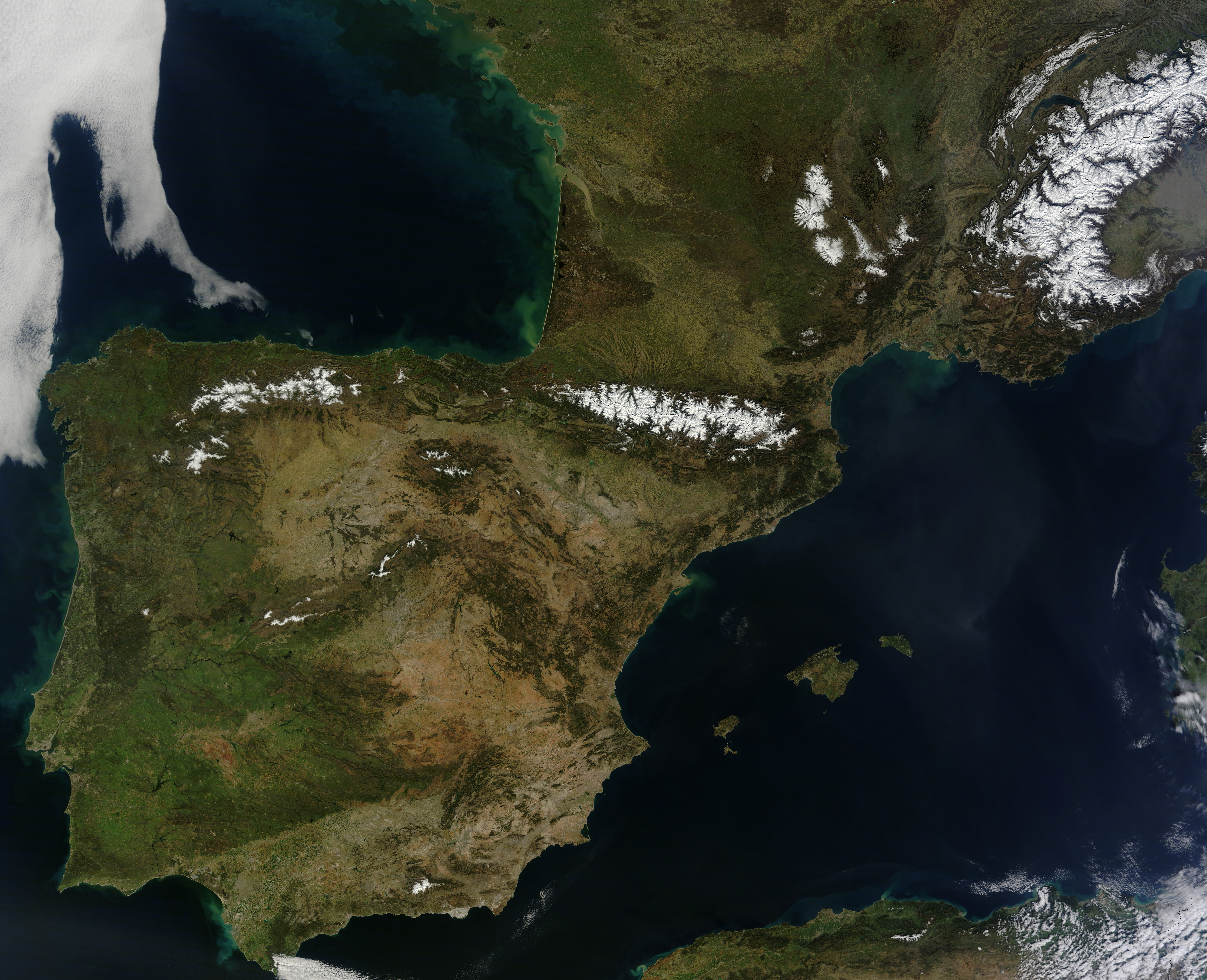
| Beschreibung | English: Rarely do weather patterns and satellite overpass schedules align to provide cloud-free views of Western Europe in the spring. However, a high-pressure pattern kept skies spectacularly clear over the Iberian Peninsula and east into France and Germany as the Moderate Resolution Imaging Spectroradiometer (MODIS) on NASA’s Terra satellite passed over on March 8, 2014. The cloud-free area began to emerge on March 5 and persisted through March 11. Explore Worldview—a near-real time browser from the MODIS Rapid Response Team—to see a wider view and how the cloud-free area changed over time. This unobstructed view of Spain, Portugal, Andorra, and southern France exposed a variety of natural features. Meseta Central, the broad mountainous plateau at the center of the Iberian Peninsula, appears brown compared to the greener coastal lowlands to the west. Near the center of the image, the snow-capped Pyrenees Mountains serve as a natural barrier between France and Spain. The Cantabrian Mountains, another range in northern Spain, are visible to the west of the Pyrenees. The snow-covered areas to the north are the highlands of France’s Massif Central. | |||||
| Datum | acquired March 8, 2014 | |||||
| Quelle | http://earthobservatory.nasa.gov/IOTD/view.php?id=83321&src=eoa-iotd | |||||
| Urheber | NASA/ Jeff Schmaltz, LANCE/EOSDIS MODIS Rapid Response Team at NASA GSFC. | |||||
| Genehmigung (Weiternutzung dieser Datei) |
|

Dateiversionen
Klicke auf einen Zeitpunkt, um diese Version zu laden.
| Version vom | Vorschaubild | Maße | Benutzer | Kommentar | |
|---|---|---|---|---|---|
| aktuell | 06:57, 13. Mär. 2014 | | 6.400 × 5.200 (8,05 MB) | Tillman | {{Information |Description ={{en|1=Rarely do weather patterns and satellite overpass schedules align to provide cloud-free views of Western Europe in the spring. However, a high-pressure pattern kept skies spectacularly clear over the Iberian Penins... |
Dateiverwendung
Keine Seiten verwenden diese Datei.
Globale Dateiverwendung
Die nachfolgenden anderen Wikis verwenden diese Datei:
- Verwendung auf bn.wikipedia.org
- Verwendung auf en.wikipedia.org
- Verwendung auf eu.wikipedia.org
- Verwendung auf fi.wikipedia.org
- Verwendung auf ug.wikipedia.org
- Verwendung auf uz.wikipedia.org