Datei:LocationNSAngloLatin.png
 Van Wikipedia, de gratis encyclopedie
Größe dieser Vorschau: 600 × 600 Pixel. Weitere Auflösungen: 240 × 240 Pixel | 480 × 480 Pixel
Originaldatei (800 × 800 Pixel, Dateigröße: 49 KB, MIME-Typ: image/png)
![]()
Diese Datei und die Informationen unter dem roten Trennstrich werden aus dem zentralen Medienarchiv Wikimedia Commons eingebunden.
![]()
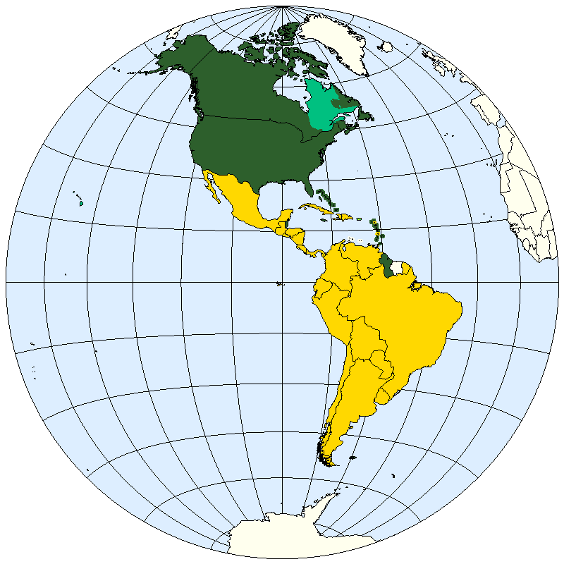
Beschreibung
| Beschreibung | Division of the Americas into Anglo-America and Latin America. |
| Datum | |
| Quelle | prepared from public domain maps created by w:en:User:E Pluribus Anthony. |
| Urheber | Spacepotato |
Legend
- 2D5F2C: Anglo-America.
- 00C080: May be included in Anglo-America or in Latin-America
- FFD800: Latin America.
- FFFC00: May be included in Latin America.
References
Anglo-America
- Broad definition: "North America". The Columbia Encyclopedia, Sixth Edition. 2001-05. Accessed on line October 11, 2007. Defines Anglo-America as Canada together with the U.S.A.
- Narrow definition: "Anglo-America". Encyclopedia Brittanica, on line. Accessed October 10, 2007. Defines Anglo-America as a "cultural entity of North America" which "comprises most of the United States and Canada, with French-speaking Canada a notable exception".
Latin America
- Broad definition: "Latin America". Brittanica Student Encyclopedia, on line. Accessed October 10, 2007. Defines Latin America as "South America, Mexico, Central America, and the West Indies".
- Intermediate definition: "Latin America". Columbia Encyclopedia, Sixth Edition, 2007. Accessed on line October 11, 2007. Defines Latin America as including the mainland independent nations south of the U.S.A. (except Belize, Guyana and Suriname), Cuba, the Dominican Republic, Haiti, and "Puerto Rico, the French West Indies, and other islands of the West Indies where a Romance tongue is spoken." Term may also include Belize, Guyana, French Guiana, and Suriname.
- Narrow definition: "Latin America". The American Heritage New Dictionary of Cultural Literacy, Third Edition, 2005. Accessed on line October 11, 2007. Defines Latin America as all of the "Spanish- or Portuguese-speaking nations south of the United States."
Lizenz
| Ich, der Urheberrechtsinhaber dieses Werkes, veröffentliche es als gemeinfrei. Dies gilt weltweit. In manchen Staaten könnte dies rechtlich nicht möglich sein. Sofern dies der Fall ist: Ich gewähre jedem das bedingungslose Recht, dieses Werk für jedweden Zweck zu nutzen, es sei denn, Bedingungen sind gesetzlich erforderlich. |
See also
- Image:LocationNSAm.png
- Image:LocationNSAm2.png
- Image:LocationNSAm3.png
- Image:LocationNSAmUNGeoscheme.png
Dateiversionen
Klicke auf einen Zeitpunkt, um diese Version zu laden.
| Version vom | Vorschaubild | Maße | Benutzer | Kommentar | |
|---|---|---|---|---|---|
| aktuell | 20:08, 22. Jan. 2021 | | 800 × 800 (49 KB) | Kiwi Rex | Corrected inaccuracies. The map was updated according to Wikipedia's (and Wiktionary's) own usage of the terms, which is already visually represented in the images File:Latin America (orthographic projection).svg and File:Anglo America (orthographic projection).svg. Countries that don't speak Latin-derived languages (such as Jamaica and Suriname) are not "Latin American". |
| 22:38, 11. Okt. 2007 |  | 800 × 800 (21 KB) | Spacepotato | {{Information |Description=Division of the Americas into Anglo-America and Latin America. |Source=prepared from public domain maps created by w:en:User:E Pluribus Anthony. |Date=October 11, 2007. |Author= Spacepotato }} ==Legend== |
.svg)
.svg&action=edit&redlink=1)
Dateiverwendung
Keine Seiten verwenden diese Datei.
Globale Dateiverwendung
Die nachfolgenden anderen Wikis verwenden diese Datei:
- Verwendung auf ar.wikipedia.org
- Verwendung auf bn.wikipedia.org
- Verwendung auf ca.wikipedia.org
- Verwendung auf en.wikipedia.org
- Verwendung auf kn.wikipedia.org
- Verwendung auf pt.wikipedia.org