Datei:World map of countries by ecological footprint (2007).svg
 Van Wikipedia, de gratis encyclopedie

Größe der PNG-Vorschau dieser SVG-Datei: 800 × 353 Pixel. Weitere aus SVG automatisch erzeugte PNG-Grafiken in verschiedenen Auflösungen: 320 × 141 Pixel | 640 × 283 Pixel | 1.024 × 452 Pixel | 1.280 × 565 Pixel | 2.560 × 1.130 Pixel | 940 × 415 Pixel
Originaldatei (SVG-Datei, Basisgröße: 940 × 415 Pixel, Dateigröße: 1,36 MB)
![]()
Diese Datei und die Informationen unter dem roten Trennstrich werden aus dem zentralen Medienarchiv Wikimedia Commons eingebunden.
![]()
Beschreibung
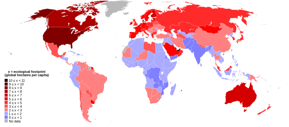
| Beschreibung | English: World map of countries shaded according to their ecological footprint in 2007 (published on 13 October 2010 by the Global Footprint Network). It is measured by the amount of global hectares that are affected by humans per capita of the country. Lighter shades denote countries with a lower ecological footprint per capita and darker shaded for countries with a higher ecological footprint per capita. The total ecological footprint (global hectares affected by humans) is measured as a total of six factors: cropland footprint, grazing footprint, forest footprint, fishing ground footprint, carbon footprint and built-up land.
Français : Mapemonde colorée selon l'empreinte écologique moyenne des habitants de chaque pays, exprimée en ha par personne, en 2007. Le tons plus chairs correspondent à une empreinte faible, les tons plus sombres à une empreinte plus forte. Six facteurs sont pris en compte pour mesurer cette empreinte: L'agriculture, le pâturage, l'exploitation forestière, la pêche, la production de carbone et l'urbanisation.
No data 0 ≤ x < 1 1 ≤ x < 2 2 ≤ x < 3 3 ≤ x < 4 4 ≤ x < 5 5 ≤ x < 6 6 ≤ x < 1 7 ≤ x < 8 8 ≤ x < 9 9 ≤ x < 10 10 ≤ x < 11 |
| Datum | |
| Quelle | Self-made with data from list of countries by ecological footprint. |
| Urheber | Jolly Janner |
| Andere Versionen |
|


.svg?uselang=de)
Lizenz
| Ich, der Urheberrechtsinhaber dieses Werkes, veröffentliche es als gemeinfrei. Dies gilt weltweit. In manchen Staaten könnte dies rechtlich nicht möglich sein. Sofern dies der Fall ist: Ich gewähre jedem das bedingungslose Recht, dieses Werk für jedweden Zweck zu nutzen, es sei denn, Bedingungen sind gesetzlich erforderlich. |
Dateiversionen
Klicke auf einen Zeitpunkt, um diese Version zu laden.
| Version vom | Vorschaubild | Maße | Benutzer | Kommentar | |
|---|---|---|---|---|---|
| aktuell | 03:24, 30. Mär. 2018 | | 940 × 415 (1,36 MB) | Sisgeo | Employ a different color for countries under 2.1 gHa, the estimated limit of sustainability. |
| 20:44, 29. Okt. 2010 |  | 940 × 415 (1,68 MB) | Jolly Janner | Added a white box to represent the background | |
| 20:38, 29. Okt. 2010 |  | 940 × 415 (1,68 MB) | Jolly Janner | white background | |
| 20:36, 29. Okt. 2010 |  | 940 × 415 (1,68 MB) | Jolly Janner | white background | |
| 20:24, 29. Okt. 2010 |  | 940 × 415 (1,68 MB) | Jolly Janner | == {{int:filedesc}} == {{Information |Description={{en|1=World map of countries shaded according to their ecological footprint in 2007 (published on 13 October 2010 by the Global Footprint Network). It is measured by the amoun |
Dateiverwendung
Keine Seiten verwenden diese Datei.
Globale Dateiverwendung
Die nachfolgenden anderen Wikis verwenden diese Datei:
- Verwendung auf ca.wikipedia.org
- Verwendung auf el.wikipedia.org
- Verwendung auf en.wikipedia.org
- Verwendung auf en.wikibooks.org
- Verwendung auf eu.wikipedia.org
- Verwendung auf fa.wikipedia.org
- Verwendung auf fr.wikipedia.org
- Verwendung auf gl.wikipedia.org
- Verwendung auf hi.wikipedia.org
- Verwendung auf it.wikipedia.org
- Verwendung auf ms.wikipedia.org
- Verwendung auf nl.wikipedia.org
- Verwendung auf pl.wikipedia.org
- Verwendung auf pl.wikibooks.org
- Verwendung auf ro.wikipedia.org
- Verwendung auf sk.wikipedia.org
- Verwendung auf sr.wikipedia.org
- Verwendung auf ta.wikipedia.org
- Verwendung auf uk.wikipedia.org
- Verwendung auf zh.wikipedia.org
.svg)