Beira (Portugal)
 From Wikipedia the free encyclopedia

Beira (Portuguese pronunciation: [ˈbɐjɾɐ]) was one of the six traditional provinces or comarcas of Portugal.
The territorial extension is different from that of the area called the Beiras, which refers to three provinces of 1936, Beira Alta, Beira Baixa and Beira Litoral.
Geography[edit]
The most important cities within the borders of the traditional province are: Coimbra, Aveiro, Leiria, Viseu, Castelo Branco, Guarda, Figueira da Foz, Covilhã and Pinhel.
The main river is the Mondego; other rivers include the Vouga, Dão, Côa, Zêzere and Paiva. The largest mountain range is Serra da Estrela – Continental Portugal's highest – other ranges being the Caramulo, Marofa, Gardunha, and Bussaco.
Administrative history[edit]
After the 15th Century, the new Kingdom of Portugal was divided into six great administrative units, referred to as comarcas. Since the Middle Ages [when?] there existed the Beira Province.
1832[edit]
In 1832 this province was divided into
1936[edit]
In 1936 these were divided among three provinces, one of which contained area that was not included in Beira Province:
- Beira Alta - "natural" regions of Beira Alta and Beira Transmontana
- Beira Baixa
- Beira Litoral
Sometimes collectively referred to as the Beiras.
1976[edit]
In 1976 the provinces were abolished leaving only the 18 districts.
- Beira Alta Province:
- Beira Baixa Province:
- Beira Litoral Province:
1976 postal code areas divide the region in
1998[edit]
Law 19/98 of 1998 divided the area into
- Beira Litoral
- Beira Interior
2011[edit]
The current Centro Region of Portugal covers roughly the same area. Oeste Subregion, part of Estremadura, is the major exception. Among its twelve subregions three contain the name "Beira":
The name also is contained in the name of many small towns and villages in the area, e.g. Moimenta da Beira, Celorico da Beira, Aguiar da Beira, Mondim da Beira etc.
Maps[edit]
-
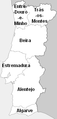 Medieval Beira
 -
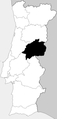
 1936 Beira Alta
 -
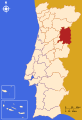
 1936 Beira Baixa
 -
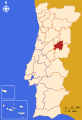
 1936 Beira Litoral
 -
 postal code regions yellow Beira Litoral, brown Beira Interior
 -
 1998 Law - Beira Litoral and Beira Interior
 -

-
-

-


See also[edit]
- Centro, Portugal
- Beira, Mozambique
- Prince of Beira, a former royal title
- Beiras wine region
- Administrative divisions of Portugal