Borujerd
 From Wikipedia the free encyclopedia
Borujerd Persian: بروجرد | |
|---|---|
City | |
 Top: Grand yard of Sultani mosque, Middle: Outlook of Zagros Mountains, Bottom left: Eftekhar-al-Eslam old house, Bottom right: the statute of Arash the Archer | |
 Borujerd | |
| Coordinates: 33°54′40″N 48°45′08″E / 33.91111°N 48.75222°E[1] | |
| Country | Iran |
| Province | Lorestan |
| County | Borujerd |
| District | Central |
| Area | |
| • Total | 43 km2 (17 sq mi) |
| Elevation | 1,573 m (5,161 ft) |
| Population (2016)[2] | |
| • Total | 234,497 |
| • Density | 5,500/km2 (14,000/sq mi) |
| Time zone | UTC+03:30 (IRST) |
| Area code | (+98) 66 |
Borujerd (Persian: بروجرد; [boɾuːˈdʒeɾd]), also Romanized as Borūjerd, is a city in the Central District of Borujerd County, Lorestan province in western Iran, serving as capital of both the county and the district.
At the 2021 National Census, its population was 334,497 in 59,388 households.[3] The following census in 2011 counted 240,654 people in 71,730 households.[4] The latest census in 2016 showed a population of 234,997 people in 74,146 households.[2]
Among the existing modern cities in Iran, Borujerd is one of the oldest reported at least since the 9th century. In Sassanid Empire, Borujerd was a small town and region neighboring Nahavand. Gaining more attention during Great Seljuq Empire in the 9th and 10th centuries, Borujerd stood as an industrial, commercial and strategic city in Zagros Mountains until the 20th century. In its golden ages, Borujerd was selected as the state capital of Lorestan and Khuzestan region during Qajar dynasty in the 18th and 19th centuries. Due to the existence of a large number of production and industrial units and the supply of their products in the domestic and foreign markets, Borujerd is considered the industrial hub of Lorestan province.
Foundation and name[edit]
The history of Borujerd before the advent of Islam is not well known. Parthian-era artifacts have been discovered in its environs by non-professional excavators. Moreover, one of Iran's oldest mosques, the Jameh Mosque of Borujerd, was constructed on the remains of a Zoroastrian fire temple. This proves that the region was populated before Islam arrived. The Parthian king Orodes II (r. 57–37 BC) is credited by some academics with laying the city's foundation. They believe that "Borujerd" stems from the Middle Persian word Wurūgird/Wulūgird/Orodhkard, meaning "built by Orodes." Others consider it to have been built by the Sasanian king Peroz I (r. 459–484), arguing that "Piruzgird" was its original name, before being changed into "Burugird", and then later Arabicised into "Burujird".[5]
History[edit]
Only from the 9th-century does the name "Borujerd" appear in Islamic chronicles. It first appears in the Kitāb al-buldān of Ibn al-Faqih (fl. 903), and is later reported in various forms, such as "Warukird", "Warugird", "Barugird" and "Barujird".[5]
Esteemed religious institutions operated in Borujerd during the Qajar era, producing two distinguished Shia scholars, Asad Allah Borujerdi (died c. 1854) and Hossein Borujerdi (died 1961).[5]
Demographics[edit]
The linguistic composition of the city:[6]
Geography and climate[edit]
Borujerd city is located approximately 1670 meters above sea level and has a moderate climate with cold winters. The highest point is Garrin Mountain 3623 m above sea level and the lowest area is Gelerood River in South with 1400 m elevation. Borujerd Township has 2600 km2 area with approximately 400,000 inhabitants distributed in the city of Oshtorinan and more than 180 villages. Owing to favorable topographic and climatic conditions, the plains are devoted to cultivation of grain. Wherever irrigation is possible (by means of qanāts, wells, diversion of water of streams), cotton, melons, grapes, and fruit trees (especially almonds) are grown.[7]
Borujerd is located on Silakhor Plain which is the largest agricultural land of Lorestan.[citation needed] The high-elevated Zagros Mountains surrounds it from South East to North West and the peaks are covered with snow most of the times. Rural people work in farms or keep their domestic animals. Other people work in governmental offices, armed forces, factories or small local businesses. The feet of Zagros Mountains is a great destination for nomads and many Lurs and Bakhtiari nomads move there in summer. The area is paved with highways and is a crossroad between Tehran and Khuzestan Province as well as Isfahan Province and Kermanshah Province.
Borujerd's climate is classified as Mediterranean(Köppen: Csa) with dry and very hot summers and cold winters. Most of the precipitation falls in colder months from November to April. Snowfall can be observed in winter, which can sometimes become heavy and cause school closures in the county. Road access to villages can also be disturbed because of snow.[8]
| Month | Jan | Feb | Mar | Apr | May | Jun | Jul | Aug | Sep | Oct | Nov | Dec | Year |
|---|---|---|---|---|---|---|---|---|---|---|---|---|---|
| Daily mean °C (°F) | 1.1 (34.0) | 3.8 (38.8) | 8.1 (46.6) | 13.1 (55.6) | 17.9 (64.2) | 23.8 (74.8) | 27.8 (82.0) | 27.4 (81.3) | 22.7 (72.9) | 16.9 (62.4) | 9.7 (49.5) | 4.6 (40.3) | 14.7 (58.5) |
| Average precipitation mm (inches) | 61.4 (2.42) | 61.8 (2.43) | 89.0 (3.50) | 68.9 (2.71) | 22.4 (0.88) | 2.5 (0.10) | 0.5 (0.02) | 0.7 (0.03) | 0.8 (0.03) | 19.9 (0.78) | 64.7 (2.55) | 65.9 (2.59) | 458.5 (18.04) |
| Source: IRIMO(temperature[9])(precipitation[10]) | |||||||||||||
Population[edit]
Borujerd City has 256,962 inhabitants (estimated for 2006) and it is the 31st largest city in Iran and the 2nd largest in Lorestan [1]. Borujerd is the industrial point of Lorestan. Its historical and cultural background as well as its remarkable nature, has changed it to a tourist destination. The city has been named as Dār-Al-Sorur which means the house of happiness. Borujerd's population was estimated about 20000 in mid-1800s. Official statistics by


Historical attractions[edit]
- Jameh Mosque of Borujerd
- Soltani Mosque of Borujerd
- Imamzadeh Ja'far, Borujerd
- Imamzadeh Ghasem, Borujerd
- Imamzadeh Ibrahim, Borujerd
- Imamzadeh Shahzadeh Abol-Hasan, Borujerd
- Imamzadeh Vallian, Borujerd
- Imamzadeh Ghasem, Borujerd
- Zavvarian Tomb of Borujerd
- Ghaleh Hatam Bridge, Borujerd
- Chalanchulan Bridge, Borujerd
- Ghorogh Hill, Borujerd
- Roomian Hill, Borujerd
- Bazaar of Borujerd
Parks and natural attractions[edit]
- Goldasht Valley, Borujerd
- Vennaii Village, Borujerd
- Chogha Hill of Borujerd
- Bishe Dalan Pound, Borujerd
- Oshtorankuh, Dorood
- Women's Park of Borujerd
Notable people from Borujerd[edit]


_06.jpg)
.jpg)


- Hossein Borujerdi, religious leader
- Abdolhossein Zarrinkoob, writer and historian
- Loris Tjeknavorian, musician
- Zahra Rahnavard, artist and politician
- Mostafa Abdollahi, director and actor
- Jafar Shahidi, historian and bibliographer
- Mehrdad Avesta, poet 20th-century
- Arvin Moazzami, athlete
- Moḥammad Mahdi Baḥr al-Ulūm, mystic
- Ahmad Khatami, professor
- Ehsan Mohajer Shojaei, athlete
- Mahvash, singer, dancer and stage performer
- Ehsan Rouzbahani, athlete
- Mohammad Boroujerdi, commander
- Ali Abdo, athlete
- Saman Salur, film director
- Mohammad Boroujerdi, commander
- Reza Beiranvand, athlete
- Iraj Rad, actor
- Farnaz Esmaeilzadeh, athlete
- Mahmoud Saremi, reporter
- Abdolmohammad Ayati, author and field of philosophy
- Mir Shamsuddin Adib-Soltani, philosopher
- Mohammad Hanif, writer
- Mohammad-Reza Zarrindast, pharmacologist
- Mahmoud Khatami, philosopher
- Bahram Ghasemi, diplomat
- Asadullah Boroujerdi, prominent
- Abolghasem Khazali, shi'i cleric
- Farnaz Esmaeilzadeh, speed climber
- Shahram Entekhabi, video and installation artist
- Salar Abdoh, novelist
- Hossein Kazemeyni Boroujerdi, twelver Shi'i
- Ahmad Moballeghi, professor
- Ehsan Mohajer Shojaei, middle-distance running
Gallery[edit]
-
 Fadak Park
 -
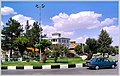 Yadbood Square.
 -
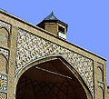 Soltani Mosque (18th century)
 -
 Goldasht Valley.
 -
 Imamzadeh Ja'far (11th century)
 -
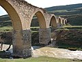 Qale Hatam Bridge
 -

-
 Countryside of Borujerd.
 -
 Borujerd View of Takhti street.
 -
 Borujerd downtown


.JPG)


See also[edit]
![]() Borujerd travel guide from Wikivoyage
Borujerd travel guide from Wikivoyage
References[edit]
- ^ OpenStreetMap contributors (23 August 2023). "Borujerd, Borujerd County" (Map). OpenStreetMap. Retrieved 23 August 2023.
- ^ a b "Census of the Islamic Republic of Iran, 1395 (2016)". AMAR (in Persian). The Statistical Center of Iran. p. 15. Archived from the original (Excel) on 12 October 2020. Retrieved 19 December 2022.
- ^ "Census of the Islamic Republic of Iran, 1385 (2006)". AMAR (in Persian). The Statistical Center of Iran. p. 15. Archived from the original (Excel) on 20 September 2011. Retrieved 25 September 2022.
- ^ "Census of the Islamic Republic of Iran, 1390 (2011)". Syracuse University (in Persian). The Statistical Center of Iran. p. 15. Archived from the original (Excel) on 19 January 2023. Retrieved 19 December 2022.
- ^ a b c Mobayyen 2021.
- ^ "Language distribution: individual languages and language families". Iran Atlas. Retrieved 15 September 2023.
- ^ Eckart Ehlers, “Borujerd”, Encyclopaedia Iranica. 1989
- ^ "Borujerd Snowfall". roozhayeborujerd (in Persian). Borujerd Times. Retrieved 25 March 2024.
- ^ "Form 5: Average of mean daily temperature in C. Station: Brujerd(40774)". chaharmahalmet. IRIMO. Archived from the original on 9 March 2017. Retrieved 25 March 2024.
{{cite web}}: CS1 maint: unfit URL (link) - ^ "Form 25: Monthly total of precipitation in mm. Station: Broujerd(40774)". Chaharmahalmet (asp). I.R. of Iran Meteorological Organization. Archived from the original on 23 January 2015. Retrieved 25 March 2024.
{{cite web}}: CS1 maint: postscript (link) CS1 maint: unfit URL (link)
Sources[edit]
- Mobayyen, Abolhasan (2021). "Burūjird". In Madelung, Wilferd; Daftary, Farhad (eds.). Encyclopaedia Islamica Online. Brill Online. ISSN 1875-9831.
External links[edit]
- Borujerd Information Portal
- Encyclopedia of the Orient Archived 2010-12-16 at the Wayback Machine
| International | |
|---|---|
| National | |
Lorestan Province, Iran | |||||||||||||||||||||||
|---|---|---|---|---|---|---|---|---|---|---|---|---|---|---|---|---|---|---|---|---|---|---|---|
| Capital |  | ||||||||||||||||||||||
| Counties and cities |
| ||||||||||||||||||||||
| Sights |
| ||||||||||||||||||||||
| populated places | |||||||||||||||||||||||