Corral Hollow
 From Wikipedia the free encyclopedia
| Corral Hollow | |
|---|---|
| El Arroyo de los Buenos Ayres | |
 Corral Hollow Location in the state of California | |
| Floor elevation | 121 m (397 ft)[1] |
| Geography | |
| Location | Alameda and San Joaquin counties, California |
| Coordinates | 37°39′28″N 121°28′38″W / 37.6579°N 121.47724°W |
| Traversed by | Corral Hollow Creek |
| Reference no. | 755[2] |
Corral Hollow, formed by Corral Hollow Creek, is a canyon partially located in Alameda County, with parts in San Joaquin County, 6.5 miles (10.5 km) southwest of Tracy, California. Corral Hollow Creek, formerly El Arroyo de los Buenos Ayres (The Creek of the Good Winds), from its source 1.9 miles (3.1 km) north of Mount Boardman, flows north 1.89 miles where it turns to flow west-northwest 8.5 miles (13.7 km) then turns abruptly east in the vicinity of Tesla to flow 5 miles (8.0 km) east where it turns again in a northeasterly direction for 6 miles (9.7 km) to the Delta-Mendota Canal in the San Joaquin Valley.[1][3]
History[edit]
Etymology[edit]
El Camino Viejo, the oldest route between Los Angeles and San Francisco, passed to the west through the canyon then known as El Arroyo de los Buenos Ayres over the Portezuela de Buenos Ayres (Pass of Good Winds) to the Arroyo Seco and the Livermore Valley. The '49ers traveled through the canyon now named Corral Hollow on their way to the gold fields, as did the first mail to the Tuolumne mines. The name change was perhaps because at its mouth there was a large corral for catching wild horses. This "caral" was mentioned in the California Star on March 18, 1848:
- "We are credibly informed...that a number countrymen with several Californians are actively engaged in building an extensive caral, or enclosure, in the valley of the river San Joaquin, for the purpose of capturing wild horses. The caral...will enclose twenty-five acres of land..."[4]
However, the name of the creek did not change for some time. The name "Arroyo Buenos Ayres" appears on Charles Drayton Gibbes' "Map of the Southern Mines" in 1852.[5] An 1857 map of California shows the canyon was named Corral Hollow, but Buenos Ayres Creek, although anglicised, remained with its old name.[6] By 1873, a State Geological Survey map indicated the name change was complete to Corral Hollow Creek and Corral Hollow Pass.[7]
Early settlements[edit]
California Historical Landmark #755 indicates the site of the home of its first settler, Edward B. Carrell, which was built here at the former site of an Indian village. The men and animals received food and drink at Wright's Zink House, five hundred yards north of the landmark site.[8] California Landmark #755 (now missing) was located 1.5 miles west of I-580 on County Hwy J2, Corral Hollow Road.[9] (Coordinates on this page mark that site.)
Carnegie and Tesla[edit]
Some miles up the Corral Hollow Road in the canyon is the site of the former town of Carnegie. A few miles on, beyond the Alameda County line where the road becomes the Tesla Road, is the site of coal mining that began in 1855, and later was the site of the former mining town of Tesla. Tesla appeared in 1889, as the San Francisco & San Joaquin Coal Company built the Alameda and San Joaquin Railroad line to the coal mines. When clay was discovered in the coal mine, the Carnegie Brick and Pottery Company was formed in 1902, and its plant built four miles east of Tesla, to make brick and terra cotta. In 1904, the Pottery sewer pipe plant was built between Carnegie and Tesla. Carnegie became a town with a population of about 300; Tesla had a population of over 1200. The towns were abandoned after a 1911 flood, which destroyed the railroad and workings and the Company could not afford to rebuild. The rail line from Carbona was abandoned by the Western Pacific Railroad in January 1916.[10] 99 years after the abandonment of the town, the unrelated Tesla Factory began operating about 20 miles west of the location of the former town.
Upper Canyon[edit]
The canyon turns to the southwest beyond the site of Tesla and ascends into the hills back into San Joaquin County. After passing the site of Tesla, the Tesla Road turns northwestward and winds up the side of a canyon into the Corral Hollow Pass and crosses over to the Arroyo Seco, and follows it as it descends into the Livermore Valley.
Today[edit]
Today the former town site of Tesla (named after Nikola Tesla in 1897 by San Francisco millionaire John Treadwell[11]) is within the Carnegie State Vehicular Recreation Area. The Carnegie town site partly within the Recreation Area; the rest is on the hillside on the north side of the Tesla Road where it intersects Carnegie Ridge Road.
References[edit]
- ^ a b "Feature Detail Report for: Corral Hollow". Geographic Names Information System. United States Geological Survey, United States Department of the Interior.
- ^ "Corral Hollow". Office of Historic Preservation, California State Parks. Retrieved 2012-10-14.
- ^ "Feature Detail Report for: Corral Hollow Creek". Geographic Names Information System. United States Geological Survey. Retrieved November 8, 2011.
- ^ Gudde, Erwin Gustav (1960). Erwin Gustav Gudde, California Place Names, 3rd Edition, University of California Press, 1974, p.75-76 Corral Hollow: Canyon, Creek, Pass. Retrieved 2012-06-25.
- ^ "Map of the southern mines: (Calif.) 1852 by Charles Drayton Gibbes, The Bancroft Library, University of California, Berkeley, CA 94720-6000". Content.cdlib.org. 2006-09-28. Retrieved 2012-06-25.
- ^ Britton & Rey's Map Of The State Of California. Compiled from the U.S. Land & Coast Surveys, the several Military, Scientific & Rail Road Explorations, the State & County Boundary Surveys made under the Order of the Surveyor General of California, & from Private Surveys. By George H. Goddard, C.E. Completed with Additions & Corrections up to the day of publication from the U.S. Land Office & other reliable sources. Lithy. Of Britton & Rey, Montgomery St. Cor. Commercial, S.F., 1857 by Britton & Rey California. Engraved by H. Steinegger.
- ^ State Geological Survey Of California. J.D. Whitney, State Geologist. Map Of The Region Adjacent To The Bay Of San Francisco. 1873. The Coast, Rancho, Township and Section Lines from Materials furnished by the U.S. Coast Survey and the U.S. Surveyor General's Office, the Topography chiefly from Original Surveys by C.F. Hoffman ... Julius Bien, Lith., 1873.
- ^ Kyle, Douglas E.; Rensch, Hero Eugene; Rensch, Ethel Grace; Hoover, Mildred Brooke; Abeloe, William (6 September 2002). Mildred Brooke Hoover, Douglas E. Kyle, Historic spots in California, p. 378. ISBN 9780804778176. Retrieved 2012-06-25.
- ^ Alvis Hendley. "California Landmark 755". Noehill.com. Retrieved 2012-06-25.
- ^ "Dan L. Mosier, Brief History of the Tesla Area" (PDF). Retrieved 2012-06-25.
- ^ "California Coal Mining Town named "Tesla" in 1897". Tesla Memorial Society of New York.
External links[edit]
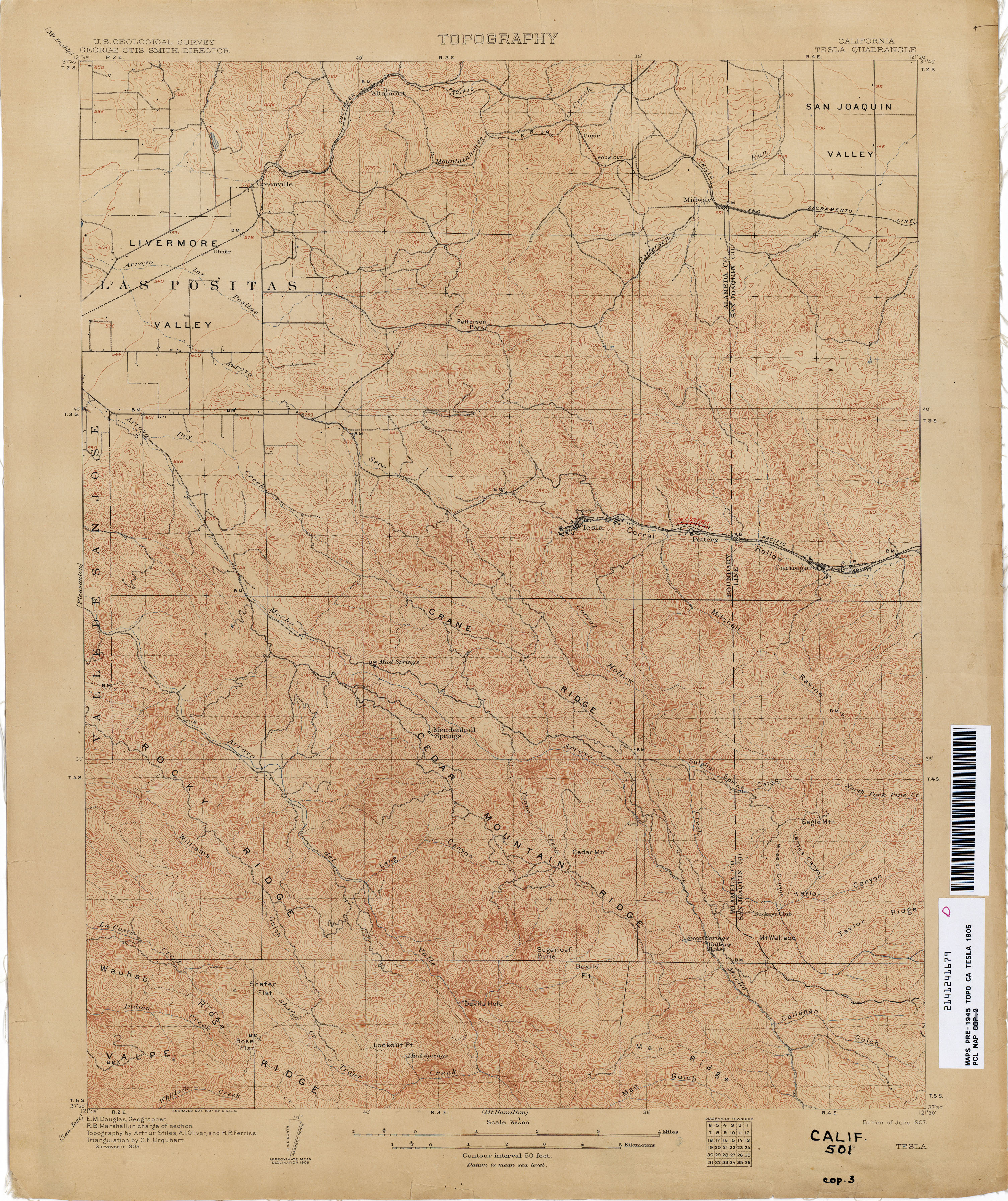
- Tesla 1905 1:62,500 from Perry–Castañeda Library, Map Collection, California Topographic Maps Topographic Map shows the extent and location of the buildings of the towns in the Corral Hollow before the flood.
Municipalities and communities of Alameda County, California, United States | ||
|---|---|---|
| Cities |  | |
| Census-designated places | ||
| Unincorporated communities | ||
| Annexed communities | ||
| Former townships | ||
| Former communities | ||
Municipalities and communities of San Joaquin County, California, United States | ||
|---|---|---|
| Cities |  | |
| Census-designated places | ||
| Unincorporated communities | ||
| Ghost towns | ||