Gradaščica
 From Wikipedia the free encyclopedia
| Gradaščica | |
|---|---|
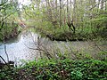
 The Gradaščica near Stranska Vas | |
| Location | |
| Country | Slovenia |
| Physical characteristics | |
| Source | |
| • elevation | 737 metres (2,418 ft) [1] |
| Mouth | |
• location | Ljubljanica |
• coordinates | 46°2′38″N 14°30′20″E / 46.04389°N 14.50556°E |
• elevation | 287 metres (942 ft) [1] |
| Length | 33 kilometres (21 mi) [1] |
| Basin features | |
| Progression | Ljubljanica→ Sava→ Danube→ Black Sea |
The Gradaščica is a river in Slovenia. The river is 33 km (21 mi) long.[1] It begins in Polhov Gradec at the confluence of Little Creek (Slovene: Mala Voda) and Big Božna Creek. Near Vrhovci it is joined by Horjulščica Creek (also known as Horjulka Creek). Not far past Bokalce, most of the stream is split off into the Mali Graben and the rest continues as the Gradaščica (also known as the Mestna Gradaščica 'Town Gradaščica'). This continues through the Vrhovci neighborhood into the Vič District, where it is joined by Glinščica Creek, before continuing into the Trnovo District and emptying into the Ljubljanica.
-
 Confluence of Horjulščica Creek (left) with the Gradaščica (right)
 -
 Beginning of the "Town Gradaščica" (left) in the Vrhovci neighborhood of Vič
 -
 Confluence of the Gradaščica (left) with Glinščica Creek (right) in Vič
 -
 Confluence of the Gradaščica with the Ljubljanica River at the Jek Bridge


Bridges[edit]
In the downstream order:
References[edit]
External links[edit]
 Media related to Gradaščica at Wikimedia Commons
- Condition of Gradaščica - graphs, in the following order, of water level, flow and temperature data for the past 30 days (taken near Dvor by ARSO)
Hydrography of Slovenia | ||
|---|---|---|
| Rivers |
|  |
| Streams | ||
| Waterfalls | ||
| Lakes | ||
| Wetlands | ||
| Sea | ||
| River valleys | ||
| Canyons and gorges | ||