Jiangxia, Wuhan
 From Wikipedia the free encyclopedia
Jiangxia 江夏区 | ||||||||||||||||||||||||||||||||||||
|---|---|---|---|---|---|---|---|---|---|---|---|---|---|---|---|---|---|---|---|---|---|---|---|---|---|---|---|---|---|---|---|---|---|---|---|---|
 A view of Jiangxia from the top of Bafen Mountain | ||||||||||||||||||||||||||||||||||||
 | ||||||||||||||||||||||||||||||||||||
 Jiangxia Location in Hubei | ||||||||||||||||||||||||||||||||||||
| Coordinates: 30°20′23″N 114°18′37″E / 30.3397°N 114.3104°E[1] | ||||||||||||||||||||||||||||||||||||
| Country | People's Republic of China | |||||||||||||||||||||||||||||||||||
| Province | Hubei | |||||||||||||||||||||||||||||||||||
| Sub-provincial city | Wuhan | |||||||||||||||||||||||||||||||||||
| Area | ||||||||||||||||||||||||||||||||||||
| • Total | 2,010.00 km2 (776.07 sq mi) | |||||||||||||||||||||||||||||||||||
| Population (2010)[3] | ||||||||||||||||||||||||||||||||||||
| • Total | 644,835 | |||||||||||||||||||||||||||||||||||
| • Density | 321/km2 (830/sq mi) | |||||||||||||||||||||||||||||||||||
| Time zone | UTC+8 (China Standard) | |||||||||||||||||||||||||||||||||||
| Postal code | 4302XX | |||||||||||||||||||||||||||||||||||
| Wuhan district map |
| |||||||||||||||||||||||||||||||||||
| Website | jiangxia | |||||||||||||||||||||||||||||||||||

Jiangxia District (simplified Chinese: 江夏区; traditional Chinese: 江夏區; pinyin: Jiāngxià Qū) is one of 13 urban districts of the prefecture-level city of Wuhan, the capital of Hubei province, China, situated on the eastern (right) bank of the Yangtze River. Jiangxia district has an area of 2,009 square kilometres (776 sq mi) and a population of 680,000.[4] It is the southernmost and most sparsely populated of Wuhan's districts.[3] It borders the districts of Caidian and Hannan across the Yangtze and Hongshan to the north, as well as the prefecture-level cities of Ezhou to the east, Huangshi to the southeast, and Xianning to the south.
Geography[edit]
Unlike most other districts into which the City of Wuhan is divided, Jingxia, until recently included no part of Wuhan's main urban core. However, in the first decades of the 21st century urban development in the southeastern part of Wuhan's urban area (south of Guanggu Circle) has spilled over from Hongshan District into Jiangxia District as well.
Most of Jiangxia District still consists of the rural area south of the Wuhan city center. Jingxia has its own urban core, which is a large residential area called Zhifang (纸坊) some 20 kilometres (12 mi) south of Wuhan proper.
The Longquanshan Scenic Area (龙泉山), which contains the tombs of the Ming Princes of Chu (Wuchang-based descendants of the Hongwu Emperor) is located in the northeastern part of Jiangxi District.[5] That area must have been quite rural, and remote from the provincial capital, Wuchang, in the Ming days; but today's Wuhan has spread to within a few kilometers of Longquanshan.
Administrative divisions[edit]
Jiangxia District administers:[6][7]
| Name (translation) | Chinese (S) |
|---|---|
| Zhifang Subdistrict | 纸坊街道 |
| Jinkou Subdistrict | 金口街道 |
| Wulongquan Subdistrict | 乌龙泉街道 |
| Zhengdian Subdistrict | 郑店街道 |
| Wulijie Subdistrict | 五里界街道 |
| Longquan Subdistrict | 龙泉街道 |
| Baoxie Subdistrict | 豹澥街道 |
| Shanpo Subdistrict | 山坡街道 |
| Fasi Subdistrict | 法泗街道 |
| Husi Subdistrict | 湖泗街道 |
| Shu'an Subdistrict | 舒安街道 |
| Anshan Subdistrict | 安山街道 |
| Fozuling Subdistrict | 佛祖岭街道(东湖开发区) |
| Guandong Subdistrict | 关东街道 |
| Binhu Subdistrict | 滨湖街道 |
| Jinshui Office | 金水办事处 |
| Dawuchen Office | 大屋陈办事处 |
| Miaoshan Office | 庙山办事处(江夏经济开发区) |
| Canglongdao Office | 藏龙岛办事处 |
| Daqiao New Area Office | 大桥新区办事处 |
| Jingang New Area | 金港新区 |
| Liangzihu Scenic Spot Office | 梁子湖风景区办事处 |
Climate[edit]
| Climate data for Jiangxia District (1991–2020 normals) | |||||||||||||
|---|---|---|---|---|---|---|---|---|---|---|---|---|---|
| Month | Jan | Feb | Mar | Apr | May | Jun | Jul | Aug | Sep | Oct | Nov | Dec | Year |
| Mean daily maximum °C (°F) | 8.2 (46.8) | 11.3 (52.3) | 16.0 (60.8) | 22.5 (72.5) | 27.1 (80.8) | 30.1 (86.2) | 33.1 (91.6) | 32.9 (91.2) | 28.9 (84.0) | 23.3 (73.9) | 17.1 (62.8) | 10.8 (51.4) | 21.8 (71.2) |
| Daily mean °C (°F) | 4.5 (40.1) | 7.2 (45.0) | 11.6 (52.9) | 17.7 (63.9) | 22.6 (72.7) | 26.0 (78.8) | 29.0 (84.2) | 28.6 (83.5) | 24.5 (76.1) | 18.8 (65.8) | 12.6 (54.7) | 6.8 (44.2) | 17.5 (63.5) |
| Mean daily minimum °C (°F) | 1.9 (35.4) | 4.3 (39.7) | 8.3 (46.9) | 14.0 (57.2) | 18.9 (66.0) | 22.7 (72.9) | 25.8 (78.4) | 25.3 (77.5) | 21.1 (70.0) | 15.4 (59.7) | 9.4 (48.9) | 3.9 (39.0) | 14.3 (57.6) |
| Average precipitation mm (inches) | 59.7 (2.35) | 74.7 (2.94) | 103.0 (4.06) | 154.1 (6.07) | 168.3 (6.63) | 229.5 (9.04) | 252.9 (9.96) | 106.7 (4.20) | 71.2 (2.80) | 73.2 (2.88) | 60.8 (2.39) | 35.4 (1.39) | 1,389.5 (54.71) |
| Average precipitation days (≥ 0.1 mm) | 10.2 | 11.1 | 13.4 | 12.2 | 12.8 | 12.5 | 11.4 | 10.2 | 7.6 | 8.7 | 8.9 | 7.7 | 126.7 |
| Average snowy days | 3.9 | 2.0 | 0.8 | 0 | 0 | 0 | 0 | 0 | 0 | 0 | 0.3 | 1.2 | 8.2 |
| Average relative humidity (%) | 75 | 75 | 75 | 74 | 75 | 80 | 78 | 77 | 75 | 73 | 73 | 71 | 75 |
| Mean monthly sunshine hours | 92.0 | 90.7 | 119.1 | 142.7 | 160.2 | 151.6 | 204.9 | 205.5 | 165.8 | 146.3 | 128.6 | 119.1 | 1,726.5 |
| Percent possible sunshine | 28 | 29 | 32 | 37 | 38 | 36 | 48 | 51 | 45 | 42 | 41 | 38 | 39 |
| Source: China Meteorological Administration[8][9] | |||||||||||||
Infrastructure[edit]
The Wuhan authorities with the approval of the central authorities are building a temporary 1000-bed hospital in Jiangxia District to cope with the Wuhan coronavirus in January 2020.[10] This is the second hospital to cope with the outbreak.[10]
Transport[edit]
There are two stations of the Line 8, Wuhan Metro in Jiangxia District: Huangjiahu Metro Town Station and Military Game Athlete Village Station.
The Wulongquan East Railway Station (presently, no passenger service) which is part of the Wuhan-Guangzhou High-speed Railway is located within the district.
The Wuhan–Xianning Intercity Railway, the region's first dedicated commuter rail line, opened in the late 2013, has several stations in the district. In particular, the Zhifang East Station (纸坊东站; 30°21′22″N 114°20′21″E / 30.356176°N 114.339223°E) serves the district's urban core. It takes 40-50 min by commuter train from Zhifang East to Wuhan's Wuchang Railway Station.[11]
As of 2012, the authorities were considering repurposing the military Shanpo Airfield (山坡机场; 30°05′17″N 114°18′52″E / 30.08806°N 114.31444°E), located in the district's Shanpo Township (Shanpo Subdistrict since August 2011),[12] as a commercial cargo airport. The possibility for dual civil and military use is considered as well. If the plans are implemented, Shanpo will become Wuhan's second airport (after Tianhe).[13]
Gallery[edit]
-
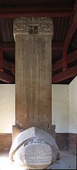 The tortoise-borne memorial stele for Zhu Zhen (1367-1424), the first of the Ming Princes of Chu buried at Longquanshan
 -
 Most of Jiangxia is rural


References[edit]
- ^ Google (2014-07-02). "Jiangxia" (Map). Google Maps. Google. Retrieved 2014-07-02.
- ^ "Wuhan Statistical Yearbook 2010" (PDF). Wuhan Statistics Bureau. Archived from the original (PDF) on 5 November 2011. Retrieved 31 July 2011.p. 15
- ^ a b "武汉市2010年第六次全国人口普查主要数据公报". Wuhan Statistics Bureau. 10 May 2011. Archived from the original on 25 October 2011. Retrieved 11 July 2011.
- ^ "Profile of Jiangxia District" (in Chinese). Official website of Jiangxia District Government. 2007-05-28. Archived from the original on 2009-05-28. Retrieved 2008-10-15.
- ^ 明楚王墓群 (The tombs of Ming Princes of Chu) - Jiangxia District Government site
- ^ 武汉市江夏区人民政府 乡镇街(办事处) (in Chinese). 江夏区人民政府办公室. Archived from the original on 24 March 2020. Retrieved 22 December 2017.
1 文明城市建设有"奇招" 2 大桥新区简介 3 法泗街简介 4 纸坊街道办 5 金口街道办 6 乌龙泉街道办 7 法泗镇 8 安山镇 9 湖泗镇 10 五里界街道办 11 山坡乡 12 舒安乡 13 金水办事处 14 庙山办事处 15 藏龙岛办事处 16 大桥新区
- ^ "江夏区历史沿革 (translation: The Historical Development of Jiangxia District" (in Chinese). 行政区划网站 (translation: Administrative Divisions Website). 6 August 2014. Retrieved 22 December 2017.
2010年第六次人口普查,江夏区常住总人口790117人,其中:纸坊街道189290人,金口街道52560人,乌龙泉街道31535人,郑店街道36969人,五里界街道25773人,金水办事处5437人,法泗镇16982人,安山镇13303人,湖泗镇13669人,山坡乡29148人,舒安乡8909人;(东湖开发区)佛祖岭办事处94290人,豹澥办事处24592人,流芳街道14336人,大屋陈办事处12064人;(江夏经济开发区)庙山办事处53920人,藏龙岛办事处97474人,大桥新区办事处66087人,梁子湖风景区办事处3779人。2011年1月,撤销安山镇,设立安山街道,办事处驻马安路36号。2011年7月,撤销豹澥镇,设立豹澥街道,办事处驻桥南路特1号;同时新设立关东、佛祖岭、滨湖3个街道,办事处分别驻南湖大道81号、流芳老街6号、中屋田街特1号。2011年8月,撤销山坡乡,设立山坡街道,办事处驻山坡新街49号。2011年末,将金口街道部分区域划出设立金港新区。2011年末,全区总面积2008.98平方千米,户籍总人口585480人(包括山坡机场203人),其中非农业人口214145人。辖7个街道、2个镇、1个乡,1个办事处、4个开发区管委会,52个社区、268个行政村,2688个村民小组。(武汉年鉴2012数据)2012年3月,撤销法泗镇,设立法泗街道,办事处驻法泗洲76号。2012年7月,撤销湖泗镇,设立湖泗街道,办事处驻南墩街49号。2012年12月,撤销舒安乡,设立舒安街道,办事处驻梁湖路89号。2013年10月,流芳街道更名为龙泉街道。
- ^ 中国气象数据网 – WeatherBk Data (in Simplified Chinese). China Meteorological Administration. Retrieved 23 September 2023.
- ^ 中国气象数据网 (in Simplified Chinese). China Meteorological Administration. Retrieved 23 September 2023.
- ^ a b "China Focus: Wuhan to follow Beijing's SARS treatment model in new coronavirus control - Xinhua | English.news.cn". www.xinhuanet.com. Archived from the original on January 24, 2020. Retrieved 2020-01-28.
- ^ Zhifang East train schedule (in Chinese)
- ^ "江夏区历史沿革 (translation: The Historical Development of Jiangxia District" (in Chinese). 行政区划网站 (translation: Administrative Divisions Website). 6 August 2014. Retrieved 22 December 2017.
2011年8月,撤销山坡乡,设立山坡街道,办事处驻山坡新街49号。
- ^ 武汉第二机场项目已上报发改委 江夏山坡机场开始“控违” (The plan for Wuhan's second airport has been submitted to the National Development and Reform Commission. Shanpo Airfield, in Jiangxia District, started to be considered), 2012-11-21
External links[edit]
- (in Chinese) Jiangxia government official website