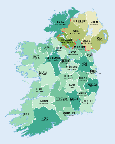
List of Irish counties by area
 From Wikipedia the free encyclopedia
This is a list of the counties of Ireland ordered by area. Counties in the Republic of Ireland are shown in normal type, while those in Northern Ireland are listed in italic type.

| Rank | County | Area (km2) | Density (/ km2) | Traditional Province |
|---|---|---|---|---|
| 1 | Cork | 7,508 [1] | 77.8 | Munster |
| 2 | Galway | 6,151 [2] | 45.1 | Connacht |
| 3 | Mayo | 5,588 [3] | 24.7 | Connacht |
| 4 | Donegal | 4,860 [4] | 34.4 | Ulster |
| 5 | Kerry | 4,807 [5] | 32.5 | Munster |
| 6 | Tipperary | 4,305 [6] | 39.0 | Munster |
| 7 | Clare | 3,450 [7] | 37.1 | Munster |
| 8 | Tyrone | 3,266 [8] | 57.6 | Ulster |
| 9 | Antrim | 3,086 [9] | 211.1 | Ulster |
| 10 | Limerick | 2,756 [10] | 76.0 | Munster |
| 11 | Roscommon | 2,548 [11] | 27.6 | Connacht |
| 12 | Down | 2,489 [9] | 222.3 | Ulster |
| 13 | Wexford | 2,367 [12] | 69.3 | Leinster |
| 14 | Meath | 2,342 [13] | 94.3 | Leinster |
| 15 | Londonderry | 2,118 [9] | 119.1 | Ulster |
| 16 | Kilkenny | 2,073 [14] | 50.2 | Leinster |
| 17 | Wicklow | 2,027 [15] | 76.9 | Leinster |
| 18 | Offaly | 2,001 [16] | 41.6 | Leinster |
| 19 | Cavan | 1,932 [17] | 42.3 | Ulster |
| 20 | Waterford | 1,858 [18] | 68.6 | Munster |
| 21 | Westmeath | 1,840 [19] | 52.3 | Leinster |
| 22 | Sligo | 1,838 [20] | 38.2 | Connacht |
| 23 | Laois | 1,720 [21] | 53.4 | Leinster |
| 24 | Kildare | 1,695 [22] | 146.2 | Leinster |
| 25 | Fermanagh | 1,691 [23] | 37.6 | Ulster |
| 26 | Leitrim | 1,589 [24] | 22.2 | Connacht |
| 27 | Armagh | 1,327 [9] | 146.5 | Ulster |
| 28 | Monaghan | 1,295 [25] | 50.4 | Ulster |
| 29 | Longford | 1,091 [26] | 42.9 | Leinster |
| 30 | Dublin | 922 [27] | 1,581.5 | Leinster |
| 31 | Carlow | 897 [28] | 69.1 | Leinster |
| 32 | Louth | 826 [29] | 169.1 | Leinster |
| Average | 2,633 | |||
| Total | Ireland | 84,421 | 83.5 |
See also
- List of Irish counties by population
- List of Irish counties by highest point
- List of Irish counties by coastline
References
- ^ "Report of the Expert Advisory Group on Local Government Arrangements in Cork". gov.ie. Department of Housing, Local Government and Heritage. Retrieved 28 October 2023.
Area (Cork County: 7,467.91 km2 / Cork City: 39.61 km2
- ^ "County Profiles – Galway". Western Development Commission. Archived from the original on 2 June 2021. Retrieved 2 June 2021.
- ^ "County Profiles – Mayo". Western Development Commission. Archived from the original on 2 June 2021. Retrieved 2 June 2021.
- ^ "County Profiles – Donegal". Western Development Commission. Archived from the original on 2 June 2021. Retrieved 2 June 2021.
- ^ [1] County Kerry
- ^ [2] County Tipperary
- ^ [3] County Clare
- ^ Northern Ireland General Register Office (1975). "Table 1: Area, Buildings for Habitation and Population, 1971". Census of Population 1971; Summary Tables (PDF). Belfast: HMSO. p. 1. Retrieved 28 August 2019.
- ^ a b c d "Areas, regions, and land divisions". Public Records Office of Northern Ireland. Archived from the original on 24 August 2015.
- ^ [4] County Limerick
- ^ [5] County Roscommon
- ^ [6] County Wexford
- ^ [7] County Meath
- ^ [8] County Kilkenny
- ^ [9] County Wicklow
- ^ [10] County Offaly
- ^ [11] County Cavan
- ^ [12] County Waterford
- ^ [13] County Westmeath
- ^ [14] County Sligo
- ^ [15] County Laois
- ^ [16] County Kildare
- ^ [17] County Fermanagh
- ^ "County Profiles – Leitrim". Western Development Commission. Retrieved 17 April 2024.
- ^ [18] County Monaghan
- ^ [19] County Longford
- ^ [20] County Dublin
- ^ [21] County Carlow
- ^ [22] County Louth