Nærøy
 From Wikipedia the free encyclopedia
Nærøy Municipality Nærøy kommune | |
|---|---|
| Nærø herred (historic name) | |
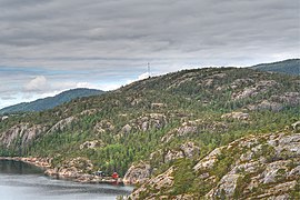
 View of the Opløfjord in Nærøy | |
 Flag | |
 Trøndelag within Norway | |
 Nærøy within Trøndelag | |
| Coordinates: 64°56′01″N 11°46′47″E / 64.93361°N 11.77972°E | |
| Country | Norway |
| County | Trøndelag |
| District | Namdalen |
| Established | 1 Jan 1838 |
| • Created as | Formannskapsdistrikt |
| Disestablished | 1 Jan 2020 |
| • Succeeded by | Nærøysund Municipality |
| Administrative centre | Kolvereid |
| Government | |
| • Mayor (1999-2019) | Steinar Aspli (Sp) |
| Area (upon dissolution) | |
| • Total | 1,067.54 km2 (412.18 sq mi) |
| • Land | 1,013.89 km2 (391.47 sq mi) |
| • Water | 53.65 km2 (20.71 sq mi) 5% |
| • Rank | #96 in Norway |
| Population (2018) | |
| • Total | 5,117 |
| • Rank | #200 in Norway |
| • Density | 5/km2 (10/sq mi) |
| • Change (10 years) | |
| Demonym | Nærøyværing[1] |
| Official language | |
| • Norwegian form | Bokmål |
| Time zone | UTC+01:00 (CET) |
| • Summer (DST) | UTC+02:00 (CEST) |
| ISO 3166 code | NO-5051[3] |
| Website | Official website |

Nærøy (Urban East Norwegian: [ˈnæ̂ːrœʏ]) is a former municipality of Trøndelag county, Norway. The municipality existed from 1838 until its dissolution in 2020 when it joined the municipality of Nærøysund. It was part of the Namdalen region. Norway's smallest town, Kolvereid, was the administrative centre of the municipality. Some villages in Nærøy included Abelvær, Foldereid, Gravvik, Lund, Ottersøy, Salsbruket, Steine, and Torstad.
At the time of its dissolution in 2020, the 1,068-square-kilometre (412 sq mi) municipality was the 96th largest by area out of the 422 municipalities in Norway. Nærøy was the 200th most populous municipality in Norway with a population of 5,117. The municipality's population density was 5 inhabitants per square kilometre (13/sq mi) and its population had increased by 2% over the previous decade.[4][5]
General information[edit]
Nærøy was established as a municipality on 1 January 1838 (see formannskapsdistrikt). On 1 July 1869, the western island district was separated from Nærøy to become the new municipality of Vikten. This left Nærøy with 1,477 residents. On 1 January 1902, an unpopulated area of Kolvereid was transferred to Nærøy municipality.
During the 1960s, there were many municipal mergers across Norway due to the work of the Schei Committee. On 1 January 1964, the neighboring municipalities of Kolvereid (population: 2,426), Nærøy (population: 2,182), Gravvik (population: 816), and the western two-thirds of Foldereid were merged to form the new, larger municipality of Nærøy.[6]
On 1 January 2018, the municipality of Nærøy switched from the old Nord-Trøndelag county to the new Trøndelag county.
On 1 January 2020, the municipality of Nærøy was merged with most of the neighboring municipality of Vikna to form the new Nærøysund Municipality.[7] The Lund area in Nærøy was not part of the merger. It became part of the newly enlarged Namsos Municipality on the same date.[8]
Name[edit]
The municipality (originally the parish) is named after the island of Nærøya (Old Norse: Njarðøy) since the Old Nærøy Church was built there. The meaning of the first element is uncertain. It is maybe the stem form of the name of the Norse god Njord (but it is suspicious that it is not in the genitive case). The last element is øy which means "island".[9][10] Historically, the name of the municipality was spelled Nærøen or Nærø. On 3 November 1917, a royal resolution changed the spelling of the name of the municipality to Nærøy.[11]
Coat of arms[edit]
The coat of arms was granted on 22 May 1987 and they were in use until 1 January 2020 when the municipality was dissolved. The official blazon is "Or, three fleur-de-lis in pall stems conjoined gules" (Norwegian: I gull tre røde liljetopper forent i trepass). This means the arms have a field (background) that has a tincture of Or which means it is commonly colored yellow, but if it is made out of metal, then gold is used. The charge is three conjoined fleur-de-lis aligned in a Y-shaped design. The fleur-de-lis design is red to symbolize the local water lilies which generally have a reddish color. The arms are also based on the seal of King Håkon Magnusson from 1344, on a document in which the King granted several rights to the local farmers. The seal shows St. Mary in a portal decorated with fleur-de-lis, the symbol of St. Mary. The arms were designed by Einar H. Skjervold. The municipal flag has the same design as the coat of arms.[12][13][14]
Churches[edit]
The Church of Norway had four parishes (sokn) within the municipality of Nærøy. It is part of the Namdal prosti (deanery) in the Diocese of Nidaros.
| Parish (sokn) | Church name | Location of the church | Year built |
|---|---|---|---|
| Foldereid | Foldereid Church | Foldereid | 1863 |
| Gravvik | Gravvik Church | Gravvik | 1875 |
| Kolvereid | Kolvereid Church | Kolvereid | 1874 |
| Lund Chapel | Lund | 1965 | |
| Salsbruket Chapel | Salsbruket | 1950 | |
| Nærøy | Lundring Church | Lundring | 1885 |
| Steine Chapel | Steine | 1911 | |
| Torstad Chapel | Torstad | 1936 |
Geography[edit]
The municipality was located in the northwestern part of Trøndelag county, along the Foldafjord. It included the islands of Austra and Gjerdinga and the Kvingra peninsula. Several large lakes were located in the municipality including Mjosundvatnet, Salvatnet, and Storvatnet.
Government[edit]
While it existed, this municipality was responsible for primary education (through 10th grade), outpatient health services, senior citizen services, unemployment and other social services, zoning, economic development, and municipal roads. During its existence, this municipality was governed by a municipal council of elected representatives, which in turn elected a mayor.[15] The municipality fell under the Namdal District Court and the Frostating Court of Appeal.
Municipal council[edit]
The municipal council (Kommunestyre) of Nærøy is made up of 27 representatives that are elected to four year terms. The party breakdown of the final municipal council was as follows:
| Party name (in Norwegian) | Number of representatives | |
|---|---|---|
| Labour Party (Arbeiderpartiet) | 9 | |
| Progress Party (Fremskrittspartiet) | 2 | |
| Conservative Party (Høyre) | 3 | |
| Christian Democratic Party (Kristelig Folkeparti) | 1 | |
| Centre Party (Senterpartiet) | 10 | |
| Socialist Left Party (Sosialistisk Venstreparti) | 1 | |
| Liberal Party (Venstre) | 1 | |
| Total number of members: | 27 | |
| Party name (in Norwegian) | Number of representatives | |
|---|---|---|
| Labour Party (Arbeiderpartiet) | 7 | |
| Progress Party (Fremskrittspartiet) | 3 | |
| Conservative Party (Høyre) | 2 | |
| Christian Democratic Party (Kristelig Folkeparti) | 1 | |
| Centre Party (Senterpartiet) | 10 | |
| Socialist Left Party (Sosialistisk Venstreparti) | 2 | |
| Liberal Party (Venstre) | 2 | |
| Total number of members: | 27 | |
| Party name (in Norwegian) | Number of representatives | |
|---|---|---|
| Labour Party (Arbeiderpartiet) | 5 | |
| Progress Party (Fremskrittspartiet) | 4 | |
| Conservative Party (Høyre) | 2 | |
| Christian Democratic Party (Kristelig Folkeparti) | 1 | |
| Centre Party (Senterpartiet) | 10 | |
| Socialist Left Party (Sosialistisk Venstreparti) | 4 | |
| Liberal Party (Venstre) | 1 | |
| Total number of members: | 27 | |
| Party name (in Norwegian) | Number of representatives | |
|---|---|---|
| Labour Party (Arbeiderpartiet) | 8 | |
| Progress Party (Fremskrittspartiet) | 3 | |
| Conservative Party (Høyre) | 1 | |
| Christian Democratic Party (Kristelig Folkeparti) | 1 | |
| Centre Party (Senterpartiet) | 9 | |
| Socialist Left Party (Sosialistisk Venstreparti) | 3 | |
| Liberal Party (Venstre) | 2 | |
| Total number of members: | 27 | |
| Party name (in Norwegian) | Number of representatives | |
|---|---|---|
| Labour Party (Arbeiderpartiet) | 12 | |
| Progress Party (Fremskrittspartiet) | 2 | |
| Conservative Party (Høyre) | 3 | |
| Christian Democratic Party (Kristelig Folkeparti) | 2 | |
| Centre Party (Senterpartiet) | 14 | |
| Socialist Left Party (Sosialistisk Venstreparti) | 3 | |
| Liberal Party (Venstre) | 1 | |
| Total number of members: | 37 | |
| Party name (in Norwegian) | Number of representatives | |
|---|---|---|
| Labour Party (Arbeiderpartiet) | 11 | |
| Progress Party (Fremskrittspartiet) | 1 | |
| Conservative Party (Høyre) | 2 | |
| Christian Democratic Party (Kristelig Folkeparti) | 2 | |
| Centre Party (Senterpartiet) | 18 | |
| Socialist Left Party (Sosialistisk Venstreparti) | 2 | |
| Liberal Party (Venstre) | 1 | |
| Total number of members: | 37 | |
| Party name (in Norwegian) | Number of representatives | |
|---|---|---|
| Labour Party (Arbeiderpartiet) | 11 | |
| Progress Party (Fremskrittspartiet) | 1 | |
| Conservative Party (Høyre) | 2 | |
| Christian Democratic Party (Kristelig Folkeparti) | 2 | |
| Centre Party (Senterpartiet) | 16 | |
| Socialist Left Party (Sosialistisk Venstreparti) | 4 | |
| Liberal Party (Venstre) | 1 | |
| Total number of members: | 37 | |
| Party name (in Norwegian) | Number of representatives | |
|---|---|---|
| Labour Party (Arbeiderpartiet) | 17 | |
| Progress Party (Fremskrittspartiet) | 2 | |
| Conservative Party (Høyre) | 3 | |
| Christian Democratic Party (Kristelig Folkeparti) | 2 | |
| Centre Party (Senterpartiet) | 9 | |
| Socialist Left Party (Sosialistisk Venstreparti) | 2 | |
| Liberal Party (Venstre) | 2 | |
| Total number of members: | 37 | |
| Party name (in Norwegian) | Number of representatives | |
|---|---|---|
| Labour Party (Arbeiderpartiet) | 17 | |
| Conservative Party (Høyre) | 4 | |
| Christian Democratic Party (Kristelig Folkeparti) | 3 | |
| Centre Party (Senterpartiet) | 9 | |
| Socialist Left Party (Sosialistisk Venstreparti) | 2 | |
| Liberal Party (Venstre) | 2 | |
| Total number of members: | 37 | |
| Party name (in Norwegian) | Number of representatives | |
|---|---|---|
| Labour Party (Arbeiderpartiet) | 15 | |
| Conservative Party (Høyre) | 4 | |
| Christian Democratic Party (Kristelig Folkeparti) | 4 | |
| Centre Party (Senterpartiet) | 9 | |
| Socialist Left Party (Sosialistisk Venstreparti) | 2 | |
| Liberal Party (Venstre) | 3 | |
| Total number of members: | 37 | |
| Party name (in Norwegian) | Number of representatives | |
|---|---|---|
| Labour Party (Arbeiderpartiet) | 16 | |
| Conservative Party (Høyre) | 2 | |
| Christian Democratic Party (Kristelig Folkeparti) | 4 | |
| Centre Party (Senterpartiet) | 10 | |
| Socialist Left Party (Sosialistisk Venstreparti) | 2 | |
| Liberal Party (Venstre) | 3 | |
| Total number of members: | 37 | |
| Party name (in Norwegian) | Number of representatives | |
|---|---|---|
| Labour Party (Arbeiderpartiet) | 17 | |
| Conservative Party (Høyre) | 1 | |
| Communist Party (Kommunistiske Parti) | 1 | |
| Christian Democratic Party (Kristelig Folkeparti) | 4 | |
| Centre Party (Senterpartiet) | 9 | |
| Liberal Party (Venstre) | 2 | |
| Local List(s) (Lokale lister) | 3 | |
| Total number of members: | 37 | |
| Party name (in Norwegian) | Number of representatives | |
|---|---|---|
| Labour Party (Arbeiderpartiet) | 16 | |
| Conservative Party (Høyre) | 2 | |
| Communist Party (Kommunistiske Parti) | 1 | |
| Christian Democratic Party (Kristelig Folkeparti) | 3 | |
| Centre Party (Senterpartiet) | 8 | |
| Liberal Party (Venstre) | 3 | |
| Local List(s) (Lokale lister) | 4 | |
| Total number of members: | 37 | |
| Party name (in Norwegian) | Number of representatives | |
|---|---|---|
| Labour Party (Arbeiderpartiet) | 17 | |
| Conservative Party (Høyre) | 1 | |
| Communist Party (Kommunistiske Parti) | 1 | |
| Christian Democratic Party (Kristelig Folkeparti) | 3 | |
| Centre Party (Senterpartiet) | 8 | |
| Liberal Party (Venstre) | 4 | |
| Local List(s) (Lokale lister) | 3 | |
| Total number of members: | 37 | |
| Party name (in Norwegian) | Number of representatives | |
|---|---|---|
| Labour Party (Arbeiderpartiet) | 6 | |
| Christian Democratic Party (Kristelig Folkeparti) | 2 | |
| Centre Party (Senterpartiet) | 4 | |
| Liberal Party (Venstre) | 5 | |
| Total number of members: | 17 | |
| Party name (in Norwegian) | Number of representatives | |
|---|---|---|
| Labour Party (Arbeiderpartiet) | 5 | |
| Christian Democratic Party (Kristelig Folkeparti) | 3 | |
| Farmers' Party (Bondepartiet) | 4 | |
| Liberal Party (Venstre) | 4 | |
| Local List(s) (Lokale lister) | 1 | |
| Total number of members: | 17 | |
| Party name (in Norwegian) | Number of representatives | |
|---|---|---|
| Labour Party (Arbeiderpartiet) | 7 | |
| Christian Democratic Party (Kristelig Folkeparti) | 2 | |
| Farmers' Party (Bondepartiet) | 4 | |
| Liberal Party (Venstre) | 3 | |
| Total number of members: | 16 | |
| Party name (in Norwegian) | Number of representatives | |
|---|---|---|
| Labour Party (Arbeiderpartiet) | 6 | |
| Christian Democratic Party (Kristelig Folkeparti) | 2 | |
| Farmers' Party (Bondepartiet) | 4 | |
| Liberal Party (Venstre) | 4 | |
| Total number of members: | 16 | |
| Party name (in Norwegian) | Number of representatives | |
|---|---|---|
| Labour Party (Arbeiderpartiet) | 7 | |
| Farmers' Party (Bondepartiet) | 5 | |
| Liberal Party (Venstre) | 4 | |
| Total number of members: | 16 | |
| Party name (in Norwegian) | Number of representatives | |
|---|---|---|
| Labour Party (Arbeiderpartiet) | 4 | |
| Farmers' Party (Bondepartiet) | 4 | |
| Liberal Party (Venstre) | 4 | |
| List of workers, fishermen, and small farmholders (Arbeidere, fiskere, småbrukere liste) | 2 | |
| Joint List(s) of Non-Socialist Parties (Borgerlige Felleslister) | 1 | |
| Local List(s) (Lokale lister) | 1 | |
| Total number of members: | 16 | |
| Note: Due to the German occupation of Norway during World War II, no elections were held for new municipal councils until after the war ended in 1945. | ||
Mayors[edit]
The mayors of Nærøy:[33][34][35]
- 1837–1839: Paul Anzjøn
- 1840–1841: Knud Grimstad
- 1842–1843: Lorns H. Lyngsnes
- 1844–1847: Gerhard Willemsen Iversen
- 1848–1849: Matheus Anzjøn
- 1850–1851: Conrad M. Anzjøn
- 1852–1855: Christian Sverdrup
- 1856–1857: Arendt Lund
- 1858–1859: Fredrik Jensen Storval
- 1860–1861: Conrad M. Anzjøn
- 1862–1863: Ole Thomassen Thorland
- 1864–1865: Fredrik Jensen Storval
- 1866–1868: Peder C. Lund
- 1869–1871: Christian Sverdrup
- 1872–1873: Ole Thomassen Thorland
- 1874–1875: Peter Andreas Strand
- 1876–1879: Peter Olaus Varø
- 1880–1883: Johan Pedersen Laugen (V)
- 1884–1885: Bernt O. Søraa
- 1886–1889: Johan Pedersen Laugen (V)
- 1890–1891: Johan Eliassen Storvedde (V)
- 1892–1895: Georg Brandtzæg (H)
- 1896–1897: Nils Halvorsen Sandnes (H)
- 1898–1904: Georg Nordrum (H)
- 1905-1905: Nils Halvorsen Sandnes (H)
- 1905–1916: Nils Christian Brandtzæg (H)
- 1917–1919: Julian Knotten (V)
- 1920–1922: Nils Christian Brandtzæg (H)
- 1923–1928: Axel Sund (V)
- 1929–1940: Olav Bog (V)
- 1941–1943: Jens Christian Williksen (NS)
- 1943–1945: Meier Jensen (NS)
- 1945-1945: Olav Bog (V)
- 1946–1947: Jens Folkestad (Bp)
- 1948–1951: Martin Strandvahl (V)
- 1952–1955: Haakon Sandnes (Bp)
- 1956–1957: Martin Strandvahl (V)
- 1958-1958: Arnvid Førde (Bp)
- 1959–1961: Kåre Hildrum (Bp)
- 1962–1967: Arne Løvmo (V)
- 1968–1969: Birger Øverås (Sp)
- 1970–1971: Ebbe Skillingstad (Sp)
- 1972–1975: Arne Ness (Ap)
- 1976–1979: Kåre Aarmo (KrF)
- 1980–1983: Odd Bach (Sp)
- 1984–1989: Åsmund Rønningen (Ap)
- 1990–1998: Hans Mo (Sp)
- 1998–2019: Steinar Aspli (Sp)
- 2019-present: Rune Arstein (H)
Transportation[edit]
Norwegian County Road 17 crosses the northeastern part of the municipality. There is a large network of bridges in the municipality that connect islands and cross fjords. Most notably is the Marøysund Bridge and Nærøysund Bridge which connect Nærøy to Vikna to the west. Also Hestøy Bridge and Smines Bridge connect the village of Lund to Fosnes municipality to the south.
Media gallery[edit]
-
 Skrøyvstad waterfall in Nærøy
 -
 View of Mjøsund
 -
 Torfjellet; pine clad hills and narrow bays and fjords are typical here
 -
 Panorama of the Langnes area in Salsbruket
 -
 View of the Nærøysund Bridge


See also[edit]
References[edit]
- ^ "Navn på steder og personer: Innbyggjarnamn" (in Norwegian). Språkrådet.
- ^ "Forskrift om målvedtak i kommunar og fylkeskommunar" (in Norwegian). Lovdata.no.
- ^ Bolstad, Erik; Thorsnæs, Geir, eds. (2023-01-26). "Kommunenummer". Store norske leksikon (in Norwegian). Kunnskapsforlaget.
- ^ Statistisk sentralbyrå (2018). "Table: 06913: Population 1 January and population changes during the calendar year (M)" (in Norwegian). Retrieved 2019-03-03.
- ^ Statistisk sentralbyrå. "09280: Area of land and fresh water (km²) (M)" (in Norwegian). Retrieved 2019-03-03.
- ^ Jukvam, Dag (1999). "Historisk oversikt over endringer i kommune- og fylkesinndelingen" (PDF) (in Norwegian). Statistisk sentralbyrå.
- ^ "Om Nærøysund kommune" (in Norwegian). Nærøysund kommune. Archived from the original on 2019-06-20. Retrieved 2019-03-03.
- ^ "Vedtak om grensejustering mellom Nærøy og Fosnes kommuner" (PDF) (in Norwegian). Retrieved 2019-12-30.
- ^ Store norske leksikon. "Nærøy – Nord-Trøndelag" (in Norwegian). Retrieved 2011-10-03.
- ^ Rygh, Oluf (1903). Norske gaardnavne: Nordre Trondhjems amt (in Norwegian) (15 ed.). Kristiania, Norge: W. C. Fabritius & sønners bogtrikkeri. p. 354.
- ^ "Norsk Lovtidende. 2den Afdeling. 1917. Samling af Love, Resolutioner m.m". Norsk Lovtidend (in Norwegian). Kristiania, Norge: Grøndahl og Søns Boktrykkeri: 1057–1065. 1917.
- ^ "Civic heraldry of Norway - Norske Kommunevåpen". Heraldry of the World. Retrieved 2023-02-15.
- ^ "Nærøy, Nord-Trøndelag (Norway)". Flags of the World. Retrieved 2023-02-15.
- ^ "Godkjenning av våpen og flagg". Lovdata.no (in Norwegian). Norges kommunal- og arbeidsdepartementet. 1987-05-22. Retrieved 2023-02-15.
- ^ Hansen, Tore; Vabo, Signy Irene, eds. (2022-09-20). "kommunestyre". Store norske leksikon (in Norwegian). Kunnskapsforlaget. Retrieved 2023-01-01.
- ^ a b c d "Table: 04813: Members of the local councils, by party/electoral list at the Municipal Council election (M)" (in Norwegian). Statistics Norway.
- ^ "Tall for Norge: Kommunestyrevalg 2011 - Nord-Trøndelag". Valg Direktoratet. Retrieved 2019-10-20.
- ^ "Kommunestyrevalget 1995" (PDF) (in Norwegian). Oslo-Kongsvinger: Statistisk sentralbyrå. 1996. Retrieved 2020-04-14.
- ^ "Kommunestyrevalget 1991" (PDF) (in Norwegian). Oslo-Kongsvinger: Statistisk sentralbyrå. 1993. Retrieved 2020-04-14.
- ^ "Kommunestyrevalget 1987" (PDF) (in Norwegian). Oslo-Kongsvinger: Statistisk sentralbyrå. 1988. Retrieved 2020-04-14.
- ^ "Kommunestyrevalget 1983" (PDF) (in Norwegian). Oslo-Kongsvinger: Statistisk sentralbyrå. 1984. Retrieved 2020-04-14.
- ^ "Kommunestyrevalget 1979" (PDF) (in Norwegian). Oslo: Statistisk sentralbyrå. 1979. Retrieved 2020-04-14.
- ^ "Kommunevalgene 1975" (PDF) (in Norwegian). Oslo: Statistisk sentralbyrå. 1977. Retrieved 2020-04-14.
- ^ "Kommunevalgene 1972" (PDF) (in Norwegian). Oslo: Statistisk sentralbyrå. 1973. Retrieved 2020-04-14.
- ^ "Kommunevalgene 1967" (PDF) (in Norwegian). Oslo: Statistisk sentralbyrå. 1967. Retrieved 2020-04-14.
- ^ "Kommunevalgene 1963" (PDF) (in Norwegian). Oslo: Statistisk sentralbyrå. 1964. Retrieved 2020-04-14.
- ^ "Kommunevalgene og Ordførervalgene 1959" (PDF) (in Norwegian). Oslo: Statistisk sentralbyrå. 1960. Retrieved 2020-04-14.
- ^ "Kommunevalgene og Ordførervalgene 1955" (PDF) (in Norwegian). Oslo: Statistisk sentralbyrå. 1957. Retrieved 2020-04-14.
- ^ "Kommunevalgene og Ordførervalgene 1951" (PDF) (in Norwegian). Oslo: Statistisk sentralbyrå. 1952. Retrieved 2020-04-14.
- ^ "Kommunevalgene og Ordførervalgene 1947" (PDF) (in Norwegian). Oslo: Statistisk sentralbyrå. 1948. Retrieved 2020-04-14.
- ^ "Kommunevalgene og Ordførervalgene 1945" (PDF) (in Norwegian). Oslo: Statistisk sentralbyrå. 1947. Retrieved 2020-04-14.
- ^ "Kommunevalgene og Ordførervalgene 1937" (PDF) (in Norwegian). Oslo: Statistisk sentralbyrå. 1938. Retrieved 2020-04-14.
- ^ Hansen, Runbjørg Bremset (2000). Nærøyfolket. Bind 1: 1800-1920 (in Norwegian). Kolvereid: Nærøy kommune. pp. 269 & 348. ISBN 8299575419.
- ^ >Hansen, Runbjørg Bremset (2004). Nærøyfolket. Bind 2: 1920-1970 (in Norwegian). Kolvereid: Nærøy kommune. p. 282. ISBN 8299575427.
- ^ Brandtzæg, Birger (1958). "Nærøy". In Fiskaa, Haakon M; Myckland, Haakon Falck (eds.). Norges bebyggelse. Nordlige seksjon. Herredsbindet for Nord-Trøndelag. Nordre del (in Norwegian). Oslo: Norsk faglitteratur. p. 132.
External links[edit]
 Trøndelag travel guide from Wikivoyage
- Municipal fact sheet from Statistics Norway (in Norwegian)
| |||||||||||||||
 | Towns and cities | ||||||||||||||
| Municipalities |
| ||||||||||||||
| |||||||||||||||
| Authority control databases: Geographic |
|---|