ملف:Golan heights rel89B.jpg


حجم هذه المعاينة: 468 × 599 بكسل. الأبعاد الأخرى: 187 × 240 بكسل | 375 × 480 بكسل | 1٬022 × 1٬308 بكسل.
الملف الأصلي (1٬022 × 1٬308 بكسل حجم الملف: 231 كيلوبايت، نوع MIME: image/jpeg)
| هذا ملف من ويكيميديا كومنز. معلومات من صفحة وصفه مبينة في الأسفل. كومنز مستودع ملفات ميديا ذو رخصة حرة. |
ملخص
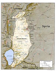
| الوصف | English: I created this image myself, by modifying the existing Image:Golan_heights_rel89A.jpg, which was itself a modified version of a modified CIA (and hence public domain) Image:Golan_92.jpg. Previous modifications were done to provide a map that was impartial about the contentious issue of which country owns the Golan Heights. The previous modifications were effective in creating a neutral map by removing the names "Syria" and "Israel" from the contentious territory and left only the label "Golan Heights". The present modification was intended solely to restore the names and locations of villages that were included on the original CIA map but had been (inadvertently) moved or erased by relocating the country titles. Due to the recurrent conflict involving villages and settlements within the Golan Heights, I feel that it is important to retain the locations on the map. As with the earlier modifications of this file, I hope that this modification will be seen as a fair compromise that also maintains the cartographical accuracy of map. I make no copyright claim on my modification; its copyright status is the same as its source. dp_roberson 15:44, 21 October 2007 (UTC) |
| التاريخ | ٢١ سبتمبر ٢٠٠٧ (تاريخ الرفع الأصيل) |
| المصدر | نُقِلت من en.wikipedia إلى كُومُنز . |
| المؤلف | Dp roberson في ويكيبيديا الإنجليزية |
ترخيص
| وضع -Dp roberson في ويكيبيديا الإنجليزية-، وهو المؤلف، هذا العمل في النِّطاق العامِّ. يسري ذلك في كل أرجاء العالم. في بعض البلدان، قد يكون هذا التَّرخيص غيرَ مُمكنٍ قانونيَّاً، في هذه الحالة: يمنح Dp roberson الجميع حق استخدام هذا العمل لأي غرض دون أي شرط ما لم يفرض القانون شروطًا إضافية. |
سجلُّ الرَّفع الأصيل
صفحة الوصف الأصلية كانت هنا، تشير جميع أسماء المستخدمين التالية إلى en.wikipedia.
- 2008-12-29 03:13 كهيعص 1022×1308× (236080 bytes) added 4 villages to the map
- 2007-09-21 15:45 Dp roberson 1022×1308× (226330 bytes) I created this image myself, by modifying the existing Image:Golan_heights_rel89A.jpg, which was itself a modified version of a modified CIA (and hence public domain) Image:Golan_92.jpg. Previous modifications were done to provide a map that was impartia
تاريخ الملف
اضغط على زمن/تاريخ لرؤية الملف كما بدا في هذا الزمن.
| زمن/تاريخ | صورة مصغرة | الأبعاد | مستخدم | تعليق | |
|---|---|---|---|---|---|
| حالي | 04:56، 27 يناير 2015 | | 1٬022 × 1٬308 (231 كيلوبايت) | Magog the Ogre | Reverted to version as of 22:56, 25 January 2015 |
| 22:56، 25 يناير 2015 |  | 468 × 599 (257 كيلوبايت) | OgreBot | (BOT): Reverting to most recent version before archival | |
| 22:56، 25 يناير 2015 |  | 1٬022 × 1٬308 (231 كيلوبايت) | OgreBot | (BOT): Uploading old version of file from en.wikipedia; originally uploaded on 2008-12-29 03:13:42 by كهيعص | |
| 13:20، 22 سبتمبر 2010 |  | 468 × 599 (257 كيلوبايت) | Ravpapa | Added the words "(Israeli occupied)" under the words "Golan Heights". This makes it clear that the area is occupied. | |
| 08:53، 5 مارس 2008 |  | 1٬022 × 1٬308 (221 كيلوبايت) | Cansado | {{Information |Description={{en|I created this image myself, by modifying the existing Image:Golan_heights_rel89A.jpg, which was itself a modified version of a modified CIA (and hence public domain) Image:Golan_92.jpg. Previous modifications were done to |
استخدام الملف
الصفحة التالية تستخدم هذا الملف:
الاستخدام العالمي للملف
الويكيات الأخرى التالية تستخدم هذا الملف:
- الاستخدام في ba.wikipedia.org
- الاستخدام في de.wikinews.org
- الاستخدام في en.wikipedia.org
- الاستخدام في ru.wikipedia.org
- الاستخدام في tr.wikipedia.org