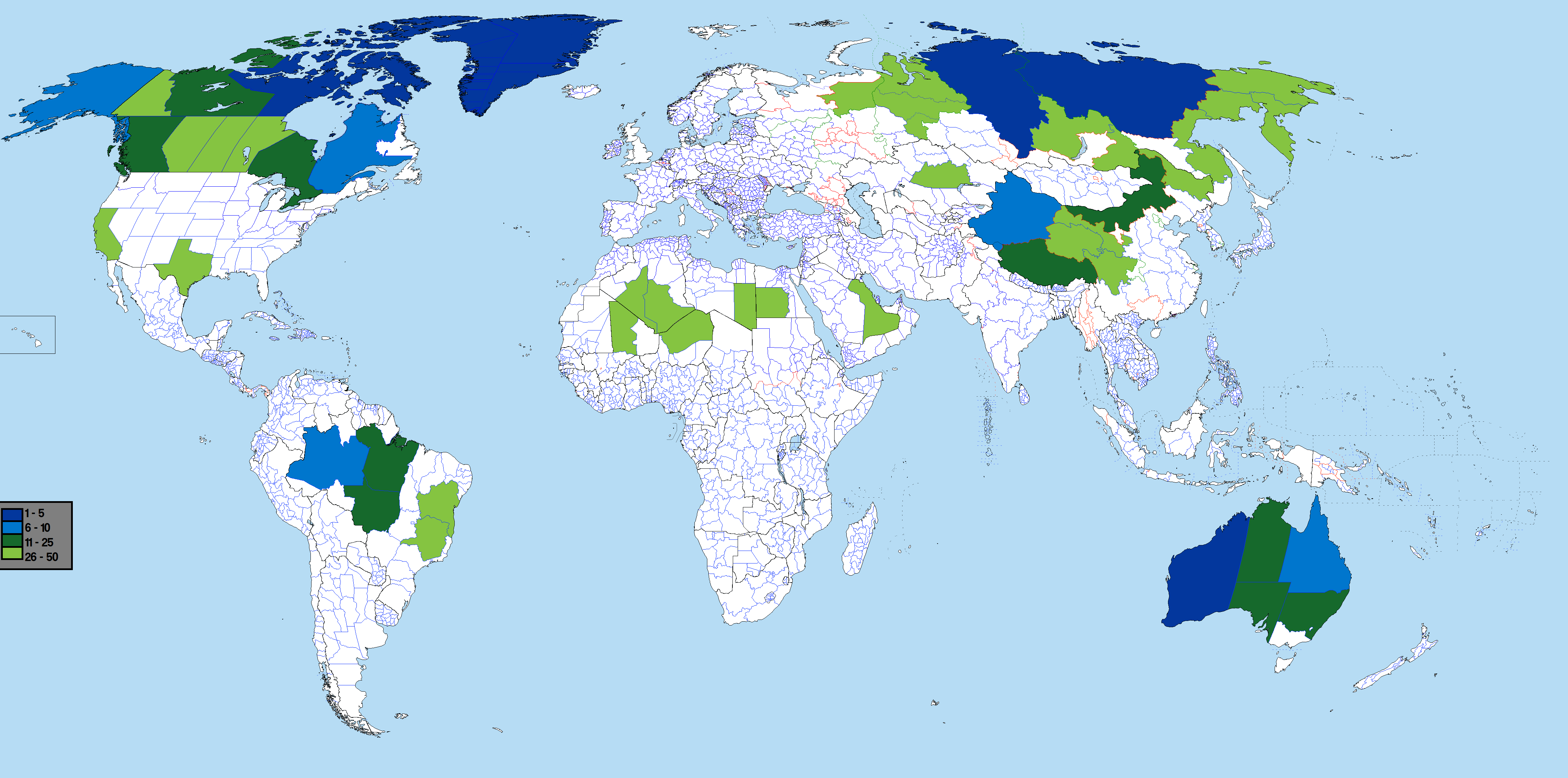
ملف:Largest World Subdivisions Area.png

حجم هذه المعاينة: 800 × 397 بكسل. الأبعاد الأخرى: 320 × 159 بكسل | 640 × 318 بكسل | 1٬024 × 508 بكسل | 1٬280 × 635 بكسل | 2٬560 × 1٬271 بكسل | 4٬500 × 2٬234 بكسل.
الملف الأصلي (4٬500 × 2٬234 بكسل حجم الملف: 566 كيلوبايت، نوع MIME: image/png)
| هذا ملف من ويكيميديا كومنز. معلومات من صفحة وصفه مبينة في الأسفل. كومنز مستودع ملفات ميديا ذو رخصة حرة. |
 | هذه map الصورة / الصورتان باستعمال رسومات متجهية ملفات رسوميات شعاعية. It is recommended to name the SVG file "Largest World Subdivisions Area.svg" - then the template Vector version available (or Vva) does not need the new image name parameter. |
ملخص
Based on Image:BlankMap-World-Subdivisions.PNG, using information from List of the largest country subdivisions by area
See also: largest subdivisions by population map
ترخيص
أنا، صاحب حقوق التأليف والنشر لهذا العمل، أنشر هذا العمل تحت الرخص التالية:
 | يسمح نسخ وتوزيع و/أو تعديل هذه الوثيقة تحت شروط رخصة جنو للوثائق الحرة، الإصدار 1.2 أو أي إصدار لاحق تنشره مؤسسة البرمجيات الحرة؛ دون أقسام ثابتة ودون نصوص أغلفة أمامية ودون نصوص أغلفة خلفية. نسخة من الرخصة تم تضمينها في القسم المسمى GNU Free Documentation License. |
| هذا الملفُّ مُرخَّص بموجب رخصة المشاع الإبداعي نسبة المُصنَّف إِلى مُؤَلِّفه - المشاركة بالمثل 3.0 العامة | ||
| ||
| تمت إضافة علامة الترخيص لهذا الملف كجزء من رخصة جنو للوثائق الحرة تحديث الترخيص. |
لك أن تختار الرخصة التي تناسبك.
تاريخ الملف
اضغط على زمن/تاريخ لرؤية الملف كما بدا في هذا الزمن.
| زمن/تاريخ | صورة مصغرة | الأبعاد | مستخدم | تعليق | |
|---|---|---|---|---|---|
| حالي | 09:58، 28 فبراير 2022 | | 4٬500 × 2٬234 (566 كيلوبايت) | Scratchinghead | Congo provinces removed, California re-added |
| 00:35، 1 سبتمبر 2019 |  | 4٬500 × 2٬234 (541 كيلوبايت) | SpencerCS | Corrected the error. California is no longer highlighted, but the New Valley Governorate is. | |
| 20:37، 13 يونيو 2017 |  | 4٬500 × 2٬234 (565 كيلوبايت) | JoaoPedro10029 | Fixed: added table, removed annoying white bar in the far left and pesky colors in the lower left canton. | |
| 20:33، 13 يونيو 2017 |  | 4٬500 × 2٬234 (332 كيلوبايت) | JoaoPedro10029 | Bigger map, can see better the subdivisions, only problem is the DRC's subdivisions that are replaced with the 2015's ones. | |
| 15:17، 20 يوليو 2016 |  | 1٬481 × 741 (65 كيلوبايت) | Andhrapur | update | |
| 00:05، 26 أكتوبر 2012 |  | 1٬481 × 741 (122 كيلوبايت) | $200inaire | Second Fix | |
| 00:03، 26 أكتوبر 2012 |  | 1٬481 × 741 (122 كيلوبايت) | $200inaire | Color tint | |
| 06:49، 2 سبتمبر 2012 |  | 1٬481 × 741 (81 كيلوبايت) | ASDFGH | update | |
| 03:24، 13 أبريل 2012 |  | 1٬427 × 628 (144 كيلوبايت) | $200inaire | Added the two DRC Provinces Orientale and Katanga. | |
| 17:06، 25 نوفمبر 2011 |  | 1٬427 × 628 (145 كيلوبايت) | Дмитрий-5-Аверин | Без Борку-Эннеди-Тибести и Эр-Рияд |
استخدام الملف
الصفحة التالية تستخدم هذا الملف:
الاستخدام العالمي للملف
الويكيات الأخرى التالية تستخدم هذا الملف:
- الاستخدام في bn.wikipedia.org
- الاستخدام في ca.wikipedia.org
- الاستخدام في fr.wikipedia.org
- الاستخدام في hu.wikipedia.org
- الاستخدام في ja.wikipedia.org
- الاستخدام في os.wikipedia.org
- الاستخدام في pt.wikipedia.org
- الاستخدام في sq.wikipedia.org
- الاستخدام في th.wikipedia.org
- الاستخدام في uk.wikipedia.org
- الاستخدام في zh.wikipedia.org