ملف:Southern Levant map.svg

الملف الأصلي(ملف SVG، أبعاده 524 × 524 بكسل، حجم الملف: 418 كيلوبايت)

ملخص

الوصف
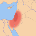
English: Location map of the en:Southern Levant, based on an approximate, geographic definition:
  • "The southern Levant, as defined here, is delimited by the Litani River to the north, the Jordan Rift Valley to the East, the Gulf of Aqaba to the south, and the Mediterranean Sea and Sinai Desert to the west."[1]
  • "The region defined as the Southern Levant encompasses the territory crossed by the valleys of the Litani and Jordan, including the Mediterranean littoral extending from Lebanon to northern Sinai. Moreover, the Negev, the Sinai peninsula and Jordan are considered parts of this vast region."[2]
  • "The southern Levant refers to all of the territory south of the headwaters of the Orontes River and west of the Syrian Desert"[3]

Legend

  Core area of the Southern Levant
  Other regions sometimes included in the Southern Levant

References

  1. Peregrine, Peter N. (٢٠٠٣) Encyclopedia of Prehistory: Volume 8: South and Southwest Asia، Springer Science & Business Media، pp. 86 ISBN: 9780306462627.
  2. Yakar, Jak (1998). "The socio-economic structure of prehistoric communities in the Southern Levant, ca. 13000-8000 BP". Documenta Praehistorica XXV.
  3. Routledge, Bruce (٢٠٠٤) Moab in the Iron Age: Hegemony, Polity, Archaeology، University of Pennsylvania Press، pp. 223 ISBN: 081223801X.
التاريخ
المصدر عمل شخصي
المؤلف Joe Roe

ترخيص

أنا، صاحب حقوق التأليف والنشر لهذا العمل، أنشر هذا العمل تحت الرخصة التالية:
w:ar:مشاع إبداعي
نسب العمل إلى مُؤَلِّفه الإلزام بترخيص المُشتقات بالمثل
يحقُّ لك:
  • مشاركة العمل – نسخ العمل وتوزيعه وبثُّه
  • إعادة إنتاج العمل – تعديل العمل
حسب الشروط التالية:
  • نسب العمل إلى مُؤَلِّفه – يلزم نسب العمل إلى مُؤَلِّفه بشكل مناسب وتوفير رابط للرخصة وتحديد ما إذا أجريت تغييرات. بالإمكان القيام بذلك بأية طريقة معقولة، ولكن ليس بأية طريقة تشير إلى أن المرخِّص يوافقك على الاستعمال.
  • الإلزام بترخيص المُشتقات بالمثل – إذا أعدت إنتاج المواد أو غيرت فيها، فيلزم أن تنشر مساهماتك المُشتقَّة عن الأصل تحت ترخيص الأصل نفسه أو تحت ترخيص مُتوافِقٍ معه.

الشروحات

أضف شرحاً من سطر واحد لما يُمثِّله هذا الملف

العناصر المصورة في هذا الملف

يُصوِّر

٢٦ يوليو 2016

تاريخ الملف

اضغط على زمن/تاريخ لرؤية الملف كما بدا في هذا الزمن.

زمن/تاريخصورة مصغرةالأبعادمستخدمتعليق
حالي14:32، 2 أغسطس 2016تصغير للنسخة بتاريخ 14:32، 2 أغسطس 2016524 × 524 (418 كيلوبايت)Joe RoeTweaked ranges per en:Talk:Southern Levant#Maps
21:05، 26 يوليو 2016تصغير للنسخة بتاريخ 21:05، 26 يوليو 2016524 × 524 (416 كيلوبايت)Joe RoeDifferentiated "core" and "inclusive" definitions
18:41، 26 يوليو 2016تصغير للنسخة بتاريخ 18:41، 26 يوليو 2016524 × 524 (391 كيلوبايت)Joe RoeUser created page with UploadWizard

الصفحة التالية تستخدم هذا الملف:

الاستخدام العالمي للملف

الويكيات الأخرى التالية تستخدم هذا الملف:

بيانات وصفية