ملف:Superpower map 1945.png


حجم هذه المعاينة: 800 × 351 بكسل. الأبعاد الأخرى: 320 × 140 بكسل | 640 × 281 بكسل | 1٬425 × 625 بكسل.
الملف الأصلي (1٬425 × 625 بكسل حجم الملف: 23 كيلوبايت، نوع MIME: image/png)
| هذا ملف من ويكيميديا كومنز. معلومات من صفحة وصفه مبينة في الأسفل. كومنز مستودع ملفات ميديا ذو رخصة حرة. |
Legend
 | هذه map الصورة / الصورتان باستعمال رسومات متجهية ملفات رسوميات شعاعية. It is recommended to name the SVG file "Superpower map 1945.svg" - then the template Vector version available (or Vva) does not need the new image name parameter. |
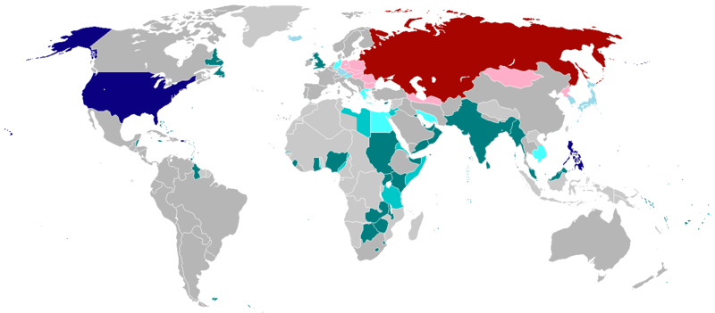
English:
English (en): Map of the world in 1945 with dependencies in lighter shading and respective superpowers at the time.
British Trust Territories
British Postwar Occupations
US postwar Occupations
Soviet postwar Occupations
বাংলা :
বাংলা (bn): ১৯৪৫ সালের মানচিত্রে পরাশক্তি ও তাদের উপর নির্ভর রাষ্ট্রসমূহ
ব্রিটিশ সাম্রাজ্য
ব্রিটিশদের বিশ্বস্ত অঞ্চলসমূহ
যুক্তরাষ্ট্র
যুক্তরাষ্ট্র বিশ্বস্ত অঞ্চলসমুহ
সোভিয়েত ইউনিয়ন
| وضع -projectname في ويكيبيديا الإنجليزية-، وهو المؤلف، هذا العمل في النِّطاق العامِّ. يسري ذلك في كل أرجاء العالم. في بعض البلدان، قد يكون هذا التَّرخيص غيرَ مُمكنٍ قانونيَّاً، في هذه الحالة: يمنح projectname الجميع حق استخدام هذا العمل لأي غرض دون أي شرط ما لم يفرض القانون شروطًا إضافية. |
.
تاريخ الملف
اضغط على زمن/تاريخ لرؤية الملف كما بدا في هذا الزمن.
| زمن/تاريخ | صورة مصغرة | الأبعاد | مستخدم | تعليق | |
|---|---|---|---|---|---|
| حالي | 01:25، 19 أكتوبر 2020 | | 1٬425 × 625 (23 كيلوبايت) | RickoTroanman22 | Fixed Hong Kong, also Tibet did not claim Inner Tibet. |
| 22:22، 6 يناير 2019 |  | 1٬425 × 625 (39 كيلوبايت) | BMacZero | colored most Aleutian Islands as United States | |
| 14:41، 2 يوليو 2017 |  | 1٬425 × 625 (39 كيلوبايت) | Fireinacrowdedtheatre | Changed New Zealand to grey; the majority-white Dominions were not under British control by 1945 (except Newfoundland). Also added Soviet occupation of central Europe and Mongolia, British occupation of Greece, American occupation of Iceland, and the B... | |
| 23:11، 7 أكتوبر 2014 |  | 1٬425 × 625 (43 كيلوبايت) | ZaidRock11 | Added post-World War II occupations in 1945 (Germany, Austria, Korea, Japan, Kwantung, Indochina); New Zealand did get full independence until 1947. | |
| 07:41، 9 يونيو 2013 |  | 1٬425 × 625 (36 كيلوبايت) | Elmor | Germany occupation zones+Saar | |
| 00:11، 10 فبراير 2012 |  | 1٬425 × 625 (51 كيلوبايت) | Quintucket | Reverted to version as of 17:28, 20 August 2011 I missed the addition of Trust territories | |
| 07:14، 28 يناير 2012 |  | 1٬357 × 628 (52 كيلوبايت) | Quintucket | Reverted to version as of 21:44, 27 June 2007 Like User:Swarm said, India and the Philippines were still colonies at the time. Belarus and Ukraine were both UN members, which doesn't mean we should show them as non-USSR | |
| 08:12، 1 ديسمبر 2011 |  | 1٬425 × 625 (57 كيلوبايت) | 23prootie~commonswiki | The Philippines and India are United Nations members in 1945 with guaranteed independence. They don't count. | |
| 17:28، 20 أغسطس 2011 |  | 1٬425 × 625 (51 كيلوبايت) | Swarm | re-add Philippines, which did not gain independence until 1946. It was commonwealth status they gained in 1934, not independence. | |
| 00:29، 27 أكتوبر 2010 |  | 1٬425 × 625 (51 كيلوبايت) | Vadac | Clearer version, the Philippines became independent in 1934, added Mandates and Trust Territories. |
استخدام الملف
الصفحة التالية تستخدم هذا الملف:
الاستخدام العالمي للملف
الويكيات الأخرى التالية تستخدم هذا الملف:
- الاستخدام في ast.wikipedia.org
- الاستخدام في az.wikipedia.org
- الاستخدام في be.wikipedia.org
- الاستخدام في el.wikipedia.org
- الاستخدام في en.wikipedia.org
- الاستخدام في es.wikipedia.org
- الاستخدام في fa.wikipedia.org
- الاستخدام في fr.wikipedia.org
- الاستخدام في he.wikipedia.org
- الاستخدام في hy.wikipedia.org
- الاستخدام في id.wikipedia.org
- الاستخدام في ja.wikipedia.org
- الاستخدام في ko.wikipedia.org
- الاستخدام في lt.wikipedia.org
- الاستخدام في no.wikipedia.org
- الاستخدام في pl.wikipedia.org
- الاستخدام في pt.wikipedia.org
- الاستخدام في ru.wikipedia.org
- الاستخدام في sco.wikipedia.org
- الاستخدام في ta.wikipedia.org
- الاستخدام في th.wikipedia.org
- الاستخدام في uz.wikipedia.org
- الاستخدام في zh-yue.wikipedia.org
- الاستخدام في zh.wikipedia.org