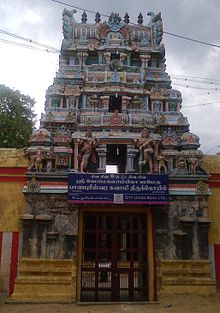
Banapuriswarar Temple
 From Wikipedia the free encyclopedia
| Banapuriswarar Temple | |
|---|---|
 Banapuriswarar Temple, Kumbakonam | |
| Religion | |
| Affiliation | Hinduism |
| District | Thanjavur |
| Deity | Banapuriswarar(Shiva ) Somakamalambal (goddess) |
| Location | |
| Location | Kumbakonam |
| State | Tamil Nadu |
| Country | India |
Banapuriswarar Temple is a Hindu temple located in the town of Kumbakonam in Tamil Nadu, India. It is dedicated to the Hindu god Shiva.[1] According to Hindu mythology, the site was the place from where Shiva took his aim at a pot of amrita with his bow and arrow.[2]
Specialty
[edit]12 Shiva temples are connected with Mahamaham festival which happens once in 12 years in Kumbakonam. They are :
- Kasi Visanathar Temple,
- Adi Kumbeswarar Temple,
- Someswarar Temple,
- Nageswaraswamy Temple,
- Kalahasteeswarar Temple,
- Gowthameswarar Temple,
- Kodeeswarar Temple,
- Amirthakadeswarar Temple,
- Banapuriswarar Temple,
- Abimukeswarar Temple,
- Kambatta Viswanathar Temple and
- Ekambareswarar Temple.
This temple is one among them.[3]
Mahasamprokshanam
[edit]The Mahasamprokshanam also known as Kumbabishegam of the temple was held on 26 October 2015.[4]
Notes
[edit]- ^ Moorthy, K. K. (1995). That Lord Siva to be adored: a mini-compendium of 300 Saivate shrines. Message Publications. p. 360.
- ^ "Banapurisvarar Temple". Online Highways.
- ^ Mahamaham Festival 2004 (in Tamil), Hindu Religious and Charitable Endowments Administration Department, Government of Tamil Nadu, 2004
- ^ "Vedaranyeswarar temple 'kumbhabhishekam' draws thousands". The Hindu. 27 October 2015. Retrieved 28 October 2015.
References
[edit]- "Kumbakonam". Hindu books. p. 8. Archived from the original on 2 February 2011. Retrieved 16 September 2012.
- "Shiva temples of Thanjavur district". Shaivam.org. Archived from the original on 25 August 2012. Retrieved 16 September 2012.
- "The Mahamaham in retrospect". The Hindu. 27 February 2004. Archived from the original on 8 May 2004.
- "Adhi Kumbeswarar Temple". Mandir.net. Archived from the original on 10 January 2012. Retrieved 16 September 2012.
10°57′53″N 79°22′54″E / 10.964657°N 79.381689°E


