Bracewell and Brogden
 From Wikipedia the free encyclopedia
| Bracewell and Brogden | |
|---|---|
 New House | |
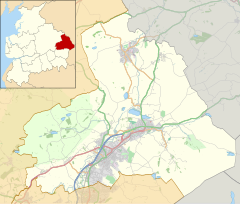
Location within Lancashire | |
| Population | 244 (2011) |
| OS grid reference | SD860484 |
| Civil parish | |
| District | |
| Shire county | |
| Region | |
| Country | England |
| Sovereign state | United Kingdom |
| Post town | SKIPTON |
| Postcode district | BD23 |
| Post town | BARNOLDSWICK |
| Postcode district | BB18 |
| Dialling code | 01282 |
| Police | Lancashire |
| Fire | Lancashire |
| Ambulance | North West |
| UK Parliament | |
Bracewell and Brogden is a former civil parish, now in the parish of Barnoldswick, in the West Craven area of the Borough of Pendle in Lancashire, England. According to the 2001 census it had a population of 238, increasing slightly to 244 at the 2011 census.[1] The parish included Bracewell (at grid reference SD863485) and Brogden (at SD858472); historically, both were in the West Riding of Yorkshire.
The parish was formed on 1 April 1987 from "Bracewell" and "Brogden" parishes.[2] On 1 April 2023, the civil parish was abolished and its territory added to Barnoldswick civil parish.[3]
Toponymy
[edit]Bracewell: from a personal name, either Braegd or Breiđ, + 'well' = 'spring or stream': hence, 'Braegd's/Breiđ's spring or stream' [4]
Brogden: 'The valley of the brook'.[5]
History
[edit]The old Roman road from Ribchester to Ilkley passes through the parish, with the remains of a 4th-century Romano-British farmstead known as Bomber Camp located next to the boundary with Gisburn.[6]
Bracewell was once a very small ancient parish in its own right. Brogden was a township in the ancient parish of Barnoldswick. It used to include the Admergill area now part of Blacko. Both were part of the Staincliffe Wapentake in the West Riding of Yorkshire. Both became civil parishes in 1866, forming part of the Skipton Rural District until 1974.[7][8]
See also
[edit]References
[edit]- ^ UK Census (2011). "Local Area Report – Bracewell and Brogden Parish (1170215069)". Nomis. Office for National Statistics. Retrieved 8 February 2018.
- ^ "Burnley and Pendle Registration District". UKBMD. Retrieved 2 August 2024.
- ^ "The Borough of Pendle Community Governance Order (No. 3)" (PDF). Local Government Boundary Commission For England. 1 April 2023. Retrieved 2 June 2024.
- ^ Ekwall, Eilert (1960). The Concise Oxford Dictionary of English Place-names (4th ed.). Oxford: Clarendon Press.
- ^ Ekwall, Eilert (1960). The Concise Oxford Dictionary of English Place-names (4th ed.). Oxford: Clarendon Press.
- ^ Historic England. "Bomber Camp Romano-British farmstead (1013817)". National Heritage List for England. Retrieved 17 March 2016.
- ^ "Bracewell AP/CP through time". visionofbritain.org.uk. GB Historical GIS / University of Portsmouth. Retrieved 2 June 2024.}
- ^ "Brogden CP/Tn through time". visionofbritain.org.uk. GB Historical GIS / University of Portsmouth. Retrieved 2 June 2024.}
External links
[edit]![]() Media related to Bracewell and Brogden at Wikimedia Commons
Media related to Bracewell and Brogden at Wikimedia Commons


