Broshniv-Osada
 From Wikipedia the free encyclopedia
Broshniv-Osada Брошнів-Осада | |
|---|---|
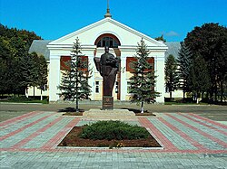
 Monument to Dmytro Vitovsky in front of the Prosvita building | |
| Coordinates: 48°59′38″N 24°11′40″E / 48.99389°N 24.19444°E | |
| Country | |
| Oblast | |
| Raion | |
| Established | 1890 |
| Government | |
| • Mayor | Taras Manoryk |
| Area | |
• Total | 5.04 km2 (1.95 sq mi) |
| Population (2022) | |
• Total | 5,419 |
| • Density | 1,100/km2 (2,800/sq mi) |
| Postal code | 77611-77613 |
| Area code | +380 3474- |
| Website | broshniv |
Broshniv-Osada (Ukrainian: Бро́шнів-Оса́да) is a rural settlement in Kalush Raion, Ivano-Frankivsk Oblast, western Ukraine. It hosts the administration of Broshniv-Osada settlement hromada, one of the hromadas of Ukraine.[1] Population: 5,419 (2022 estimate).[2]
History
[edit]The first written record of its mention dates from 1890.[3]
Until 18 July 2020, Broshniv-Osada belonged to Rozhniativ Raion. The raion was abolished in July 2020 as part of the administrative reform of Ukraine, which reduced the number of raions of Ivano-Frankivsk Oblast to six. The area of Rozhniativ Raion was merged into Kalush Raion.[4][5]
Until 26 January 2024, Broshniv-Osada was designated urban-type settlement. On this day, a new law entered into force which abolished this status, and Broshniv-Osada became a rural settlement.[6]
Gallery
[edit]- Monument to Dmytro Vitovsky in front of the Prosvita building
- Greek-Catholic Church
References
[edit]- ^ "Брошнев-Осадская громада" (in Russian). Портал об'єднаних громад України.
- ^ Чисельність наявного населення України на 1 січня 2022 [Number of Present Population of Ukraine, as of January 1, 2022] (PDF) (in Ukrainian and English). Kyiv: State Statistics Service of Ukraine. Archived (PDF) from the original on 4 July 2022.
- ^ "Broshniv-Osada settlement: street map, photos". drymba.net. Archived from the original on 25 October 2014. Retrieved 13 June 2015.
- ^ "Про утворення та ліквідацію районів. Постанова Верховної Ради України № 807-ІХ". Голос України (in Ukrainian). 2020-07-18. Retrieved 2020-10-03.
- ^ "Нові райони: карти + склад" (in Ukrainian). Міністерство розвитку громад та територій України. Archived from the original on 2020-07-18.
- ^ "Что изменится в Украине с 1 января". glavnoe.in.ua (in Russian). 1 January 2024.


