Hochstett
 From Wikipedia the free encyclopedia
You can help expand this article with text translated from the corresponding article in French. (December 2008) Click [show] for important translation instructions.
|
Hochstett Heestett | |
|---|---|
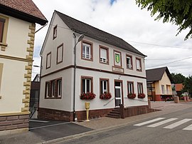
 The town hall in Hochstett | |
| Coordinates: 48°46′44″N 7°40′38″E / 48.7789°N 7.6772°E | |
| Country | France |
| Region | Grand Est |
| Department | Bas-Rhin |
| Arrondissement | Haguenau-Wissembourg |
| Canton | Haguenau |
| Intercommunality | CA Haguenau |
| Government | |
| • Mayor (2020–2026) | Clément Jung[1] |
| Area 1 | 2.13 km2 (0.82 sq mi) |
| Population (2021)[2] | 409 |
| • Density | 190/km2 (500/sq mi) |
| Time zone | UTC+01:00 (CET) |
| • Summer (DST) | UTC+02:00 (CEST) |
| INSEE/Postal code | 67203 /67170 |
| Elevation | 172–217 m (564–712 ft) |
| 1 French Land Register data, which excludes lakes, ponds, glaciers > 1 km2 (0.386 sq mi or 247 acres) and river estuaries. | |
Hochstett is a commune in the Bas-Rhin department in Grand Est in north-eastern France.[3]
Geography
[edit]Hochstett is positioned near to the autoroute that connects Strasbourg with Metz and, eventually, Paris. It is adjacent to the autoroute exit 47 which is the exit for Haguenau, although the limited access nature of the autoroute junctions in the area makes access from the autoroute to the village unexpectedly indirect.
The village is at the crossing of various minor roads, the least minor being the departmental road RD 419.
A principal element in the local economy is agriculture.
See also
[edit]References
[edit]- ^ "Répertoire national des élus: les maires" (in French). data.gouv.fr, Plateforme ouverte des données publiques françaises. 13 September 2022.
- ^ "Populations légales 2021" (in French). The National Institute of Statistics and Economic Studies. 28 December 2023.
- ^ INSEE commune file


