Itaubal
 From Wikipedia the free encyclopedia
Itaubal | |
|---|---|
 | |
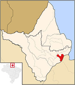
 Location of Itaubal in Amapá | |
| Coordinates: 00°35′45″N 50°40′15″W / 0.59583°N 50.67083°W | |
| Country | |
| Region | North |
| State | |
| Government | |
| • Mayor | Victor Hugo Lopes Rodrigues (PMDB) |
| Area | |
| • Total | 1,704 km2 (658 sq mi) |
| Elevation | 8.11 m (26.61 ft) |
| Population (2020) | |
| • Total | 5,617 |
| Time zone | UTC-3 |
Itaubal (Portuguese pronunciation: [itawˈbaw] also Itaubal do Piririm[1]) is a municipality located in the southeast of the state of Amapá in Brazil. Its population is 5,617[2] and its area is 1,704 square kilometres (658 sq mi). Itaubal is located 112 kilometres (70 mi) from the state capitol of Macapá.[3]
History
[edit]Itaubal was built on the right bank of the Piririm River. First reports of habitation date from 1935. In 1940, more migrants settled in the village. In 1992, it became an independent municipality.[1] The economy is based on forestry, subsistence farming and livestock.[4]
It takes its name from the itaúba (Mezilaurus itauba), a valuable species of laurel. The tree was once found in great abundance in the region, but is now endangered. Itaubal is bordered to the southeast by the delta of the Amazon River, and surrounded by Macapá to the southwest, west, and north.[3]
See also
[edit]References
[edit]- ^ a b "Itaubal". IBGE (in Portuguese). Retrieved 2 April 2021.
- ^ IBGE 2020
- ^ a b "Itaubal do Piririm" (in Portuguese). Macapá, Amapá, Brazil: Governo do Estado do Amapá. 2015. Archived from the original on 13 February 2015. Retrieved 12 February 2015.
- ^ "Itaubal do Piririm". Government of Amapá (in Portuguese). Retrieved 2 April 2021.
External links
[edit]- Official site (in Portuguese)
 Media related to Itaubal at Wikimedia Commons


