Litton Reservoirs
 From Wikipedia the free encyclopedia
| Litton Reservoirs | |
|---|---|
 Lower Reservoir | |
| Location | Somerset |
| Coordinates | 51°17′43″N 2°35′22″W / 51.29534°N 2.58941°W |
| Type | reservoirs |
| Primary inflows | River Chew |
| Primary outflows | River Chew |
| Basin countries | United Kingdom |
| Built | c. 1850 |
| Surface area | 8 acres (3.2 ha) (Lower) 16 acres (6.5 ha) (Upper) |
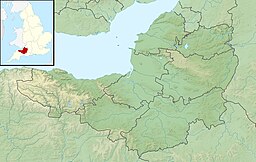
Litton Reservoirs (also known as Coley Reservoirs) (grid reference ST590553) are two reservoirs near the village of Litton, Somerset, England. They are operated by Bristol Water.
They lie on the boundary between Bath and North East Somerset and Mendip districts.
The individual lakes are called Lower Litton and Upper Litton. The former is 8 acres (32,000 m2) in size, the latter 16 acres (65,000 m2) and much deeper. They were built around 1850 by the Bristol Waterworks Company in conjunction with the "Line of Works" to bring water from the Mendip Hills to Bristol.[1]
A public footpath goes around the lakes and across the dam. The banks are home to a variety of flowers including primroses (Primula vulgaris), common bluebell (Hyacinthoides non-scripta), wood anemone (Anemone nemorosa), violets and red campion.[2]
Several species of birds are frequent visitors including moorhens, coots, mallards, mute swans and tufted ducks.[2]
Fishing (under permit) is generally for rainbow (Oncorhynchus mykiss) and brown trout (Salmo trutta). Fish breeding takes place in the netted area immediately below the upper dam is the site for fish breeding.
Photographs
[edit]- Upper dam
- Lower reservoir showing fish protection nets
- Upper reservoir taken from the dam
- Boat house on the lower Litton Reservoir
- An aerial view
References
[edit]- ^ "Floods and Spillways of the Mendip Supply Reservoirs of the Bristol waterworks Company" (PDF). 1984 Conference. British National Committee on large dams. Retrieved 26 November 2010.
- ^ a b Vile, N. (1994). Pub Walks near Bristol and Bath. Countryside Books. ISBN 1-85306-274-X.


