Liubinbu
 From Wikipedia the free encyclopedia
Liubinbu Township 刘斌堡乡 | |
|---|---|
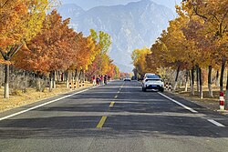
 Liubinbu section of Xianlong Highway, 2022 | |
 Location within Yanqing District | |
| Coordinates: 40°34′05″N 116°13′34″E / 40.56806°N 116.22611°E | |
| Country | China |
| Municipality | Beijing |
| District | Yanqing |
| Village-level Divisions | 1 community 16 villages |
| Area | |
| • Total | 119.5 km2 (46.1 sq mi) |
| Elevation | 583 m (1,913 ft) |
| Population (2020) | |
| • Total | 4,497 |
| • Density | 38/km2 (97/sq mi) |
| Time zone | UTC+8 (China Standard) |
| Postal code | 102104 |
| Area code | 010 |
Liubinbu Township (simplified Chinese: 刘斌堡乡; traditional Chinese: 劉斌堡鄉; pinyin: Liúbīnbǔ Xiāng) is a township situated on the northeastern side of Yanqing District, Beijing, China. It shares border with Qianjiadian Town to its north, Sihai Town to its east, Yongning Town to its south, and Xiangying Township to its west. It had 4,497 people residing within its boundaries in 2020.[1]
Geography
[edit]Liubinbu Township sits inside of a basin within Yan Mountain Range.[2] China National Highway 234 (formerly known as S323 Yanliu Road) goes through the town.
History
[edit]| Year | Status | Belong to |
|---|---|---|
| 1946 - 1951 | 3rd District | Sihai County, Hebei |
| 1951 - 1952 | 8th District | Yanqing County, Chahar |
| 1952 - 1953 | Yanqing County, Hebei | |
| 1953 - 1956 | Yingpan Township Liubinbu Township Hongguosi Township | |
| 1956 - 1957 | Liubinbu Township Hongguosi Township | |
| 1957 - 1958 | Liubinbu Township | |
| 1958 - 1967 | Liubinbu Production Team, under Yongning People's Commune | Yanqing County, Beijing |
| 1967 - 1973 | Daguantou People's Commune | |
| 1973 - 1983 | Liubinbu People's Commune | |
| 1983 - 2015 | Liubinbu Township | |
| 2015–present | Yanqing District, Beijing |
Administrative divisions
[edit]So far in 2021, Liubinbu Township is divided into 17 subdivisions, of those 1 is a community and 16 are villages. They are, by order of their Administrative Division Codes:[3]
| Subdivision Names | Name Transliterations | Type |
|---|---|---|
| 刘斌堡乡 | Liubinbuxiang | Community |
| 刘斌堡 | Liubinbu | Village |
| 大观头 | Daguantou | Village |
| 周四沟 | Zhousigou | Village |
| 红果寺 | Hongguosi | Village |
| 上虎叫 | Shang Hujiao | Village |
| 下虎叫 | Xia Hujiao | Village |
| 营盘 | Yingpan | Village |
| 营东沟 | Yingdonggou | Village |
| 马道梁 | Madaoliang | Village |
| 山西沟 | Shanxigou | Village |
| 山东沟 | Shandonggou | Village |
| 山南沟 | Shannangou | Village |
| 小观头 | Xiaoguantou | Village |
| 观西沟 | Guanxigou | Village |
| 姚官岭 | Yaoguanling | Village |
| 小吉祥 | Xiaojixiang | Village |
Gallery
[edit]- China Aviation Museum at Datanshan, 2012
- Yingpan Village, 2022
See also
[edit]References
[edit]- ^ 统计局. "北京市延庆区第七次全国人口普查公报[1]". www.bjyq.gov.cn. Retrieved 2022-10-31.
- ^ a b 李立国; 李万钧; 吴世民, eds. (2013). 中华人民共和国政区大典, 北京市卷. Beijing: 中国社会出版社. ISBN 978-7-5087-4058-4. OCLC 910451741.
- ^ "2021年统计用区划代码和城乡划分代码". www.stats.gov.cn. Retrieved 2022-10-31.


