Malaysia Federal Route 70
 From Wikipedia the free encyclopedia
This article needs additional citations for verification. (February 2017) |
| Federal Route 70 | |
|---|---|
| Jalan Kampar-Changkat Jong | |
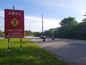
 Route 70 near Mambang Di Awan. | |
| Route information | |
| Length | 36.69 km (22.80 mi) |
| Major junctions | |
| North end | Kampar |
| South end | Changkat Jong |
| Location | |
| Country | Malaysia |
| Primary destinations | Mambang Di Awan Ayer Kuning Degong Chikus Tapah Langkap Teluk Intan |
| Highway system | |

Federal Route 70, or Jalan Kampar-Changkat Jong, is a federal road in Perak, Malaysia. The road connects Kampar in the north to Changkat Jong in the south.[1]
Route background
[edit]The Kilometre Zero of the Federal Route 70 starts at Kampar, at its interchange with the Federal Route 1, the main trunk road of the central of Peninsular Malaysia.
Features
[edit]At most sections, the Federal Route 70 was built under the JKR R5 road standard, with a speed limit of 90 km/h.
List of junctions and town
[edit]This article contains a bulleted list or table of intersections which should be presented in a properly formatted junction table. (November 2021) |
| Km | Exit | Interchange | To | Remarks | |
|---|---|---|---|---|---|
0 | Kampar | North Bukit Kayu Hitam Penang Ipoh Kuala Lumpur Southeast | T-junctions | ||
| Railway crossing bridge | |||||
| Kampung Talam | West Tanjung Tualang | T-junctions | |||
| Mambang Di Awan | |||||
| Kampar-Batang Padang district border | |||||
| Sungai Lesong | East Temoh Station Temoh | T-junctions | |||
| Sungai Lesong | |||||
| Sungai Chenderiang bridge | |||||
| Ayer Kuning | East Banir | T-junctions | |||
| Batang Padang-Hilir Perak district border | |||||
| Sungai Batang Padang bridge | |||||
| Kampung Changkat Petai | East Bukit Kayu Hitam Penang Ipoh Kuala Lumpur | Junctions | |||
| Kampung Changkat Petai | West | T-junctions | |||
| Sungai Chikus bridge | |||||
| Degong | |||||
| Railway crossing | |||||
| Langkap | Southeast Chui Chak Bidor | T-junctions | |||
| Jalan Chikus-Langkap | Northwest Chikus | T-junctions | |||
| Sungai Pahlawan bridge | |||||
| Sungai Bidor bridge | |||||
| Changkat Jong | West East Bukit Kayu Hitam Penang Ipoh Kuala Lumpur | T-junctions | |||
References
[edit]- ^ Statistik Jalan (Edisi 2013). Kuala Lumpur: Malaysian Public Works Department. 2013. pp. 16–64. ISSN 1985-9619.

