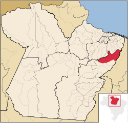
Paragominas
 From Wikipedia the free encyclopedia
Paragominas | |
|---|---|
Municipality | |
 | |
| Coordinates: 02°59′45″S 47°21′10″W / 2.99583°S 47.35278°W | |
| Country | |
| Region | Northern |
| State | Pará |
| Mesoregion | Sudeste Paraense |
| Area | |
| • Total | 7,468 sq mi (19,342 km2) |
| Elevation | 300 ft (90 m) |
| Population (2020 [1]) | |
| • Total | 114,503 |
| • Density | 15/sq mi (5.9/km2) |
| Time zone | UTC−3 (BRT) |
Paragominas is a municipality in the state of Pará in the Northern region of Brazil.[2][3][4][5] Paragominas mine, one of the largest bauxite mines in the world, is approximately 70 km away. According to an estimate dated 1 July 2020,[6] the city has a population of 111,764 and is at an altitude of 90 m above sea level. M. With a municipal area of approximately 19,342 km2, it has a population density of 5.7 inhabitants per km2, approximately the size of the state of Rhineland-Palatinate. Its distance from the capital Belém is 300 km.
Since 2011 it has been allowed to call itself Município Verde (Green City or Eco-City).
Toponimia
[edit]The name of the municipality originates from a series of abbreviations for the states of Pará, Goiás and Minas Gerais ("Para-Go-Minas").[7]
History
[edit]The city was founded in 1965.
Geography
[edit]Climate
[edit]The city has a tropical climate according to Köppen-Geiger. The average temperature is 26.6 °C. Average annual precipitation is 1805 mm.[8]
Average monthly temperature and precipitation for Paragominas
[edit]| Jan | Feb | Mär | Apr | Mai | Jun | Jul | Aug | Sep | Okt | Nov | Dez | |||
| Temperatur (°C) | 26,3 | 26,3 | 26,3 | 26,6 | 26,5 | 26,3 | 26,5 | 26,8 | 26,9 | 27,1 | 27,2 | 26,9 | Ø | 26,6 |
| Precipitation ( mm ) | 240 | 316 | 391 | 304 | 149 | 66 | 29 | 36 | 37 | 56 | 60 | 121 | Σ | 1805 |
Demography
[edit]Population
[edit]Source: IBGE (2020 figure is an estimate only).[9]

Ethnic composition
[edit]Ethnic groups according to the statistical classification of the IBGE[10]
| Group | 1991 | 2000 | 2010 | Note |
|---|---|---|---|---|
| Pardos | 48.521 | 49.139 | 66.928 | Pardo |
| Brancos | 15.167 | 20.051 | 20.215 | White |
| Pretos | 2.948 | 5.313 | 8.705 | Black |
| Amarelos | 26 | 390 | 887 | Asian |
| Indígenas | 152 | 806 | 1.084 | Indıan |
| without specification | 262 | 752 | – | |
| without specification |
See also
[edit]References
[edit]- ^ IBGE 2020
- ^ "Divisão Territorial do Brasil" (in Portuguese). Divisão Territorial do Brasil e Limites Territoriais, Instituto Brasileiro de Geografia e Estatística (IBGE). July 1, 2008. Retrieved December 17, 2009.
- ^ "Estimativas da população para 1º de julho de 2009" (PDF) (in Portuguese). Estimativas de População, Instituto Brasileiro de Geografia e Estatística (IBGE). August 14, 2009. Retrieved December 17, 2009.
- ^ "Ranking decrescente do IDH-M dos municípios do Brasil" (in Portuguese). Atlas do Desenvolvimento Humano, Programa das Nações Unidas para o Desenvolvimento (PNUD). 2000. Archived from the original on October 3, 2009. Retrieved December 17, 2009.
- ^ "Produto Interno Bruto dos Municípios 2002-2005" (PDF) (in Portuguese). Instituto Brasileiro de Geografia e Estatística (IBGE). December 19, 2007. Retrieved December 17, 2009.
- ^ "Estimativas da população residente no Brasil e unidades da federação com data de referência em 1° de julho de 2020" (PDF).
- ^ Foweraker, J. (2002-08-15). The Struggle for Land: A Political Economy of the Pioneer Frontier in Brazil from 1930 to the Present Day. Cambridge University Press. ISBN 978-0-521-52600-5.
- ^ Climate data retrieved March 31, 2018.
- ^ "Tabela 200: População residente, por sexo, situação e grupos de idade - Amostra - Características Gerais da População". sidra.ibge.gov.br. Retrieved 2022-01-13.
- ^ "Tabela 136: População residente, por cor ou raça". Gov.br. sidra.ibge.gov.br.


