Turhal District
 From Wikipedia the free encyclopedia
Turhal District | |
|---|---|
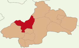
 Map showing Turhal District in Tokat Province | |
| Coordinates: 40°23′N 36°05′E / 40.383°N 36.083°E | |
| Country | Turkey |
| Province | Tokat |
| Seat | Turhal |
| Government | |
| • Kaymakam | Ali Gökay |
| Area | 940 km2 (360 sq mi) |
| Population (2022) | 78,129 |
| • Density | 83/km2 (220/sq mi) |
| Time zone | UTC+3 (TRT) |
| Website | www |
Turhal District is a district of the Tokat Province of Turkey. Its seat is the city of Turhal.[1] Its area is 940 km2,[2] and its population is 78,129 (2022).[3]
Composition
[edit]There are two municipalities in Turhal District:[1][4]
There are 52 villages in Turhal District:[5]
- Ağcaşar
- Akbuğday
- Akçatarla
- Arapören
- Arzupınarı
- Ataköy
- Ayranpınar
- Bağlarpınarı
- Bahçebaşı
- Buzluk
- Çamlıca
- Çarıksız
- Çayıraltı
- Çaylı
- Çivril
- Dazya
- Derbentçi
- Dökmetepe
- Elalmış
- Erenli
- Eriklitekke
- Gökdere
- Hamide
- Hasanlı
- Kalaycık
- Kamalı
- Kargın
- Kat
- Kazancı
- Kızkayası
- Koruluk
- Kuşoturağı
- Kuytul
- Kuzalan
- Necipköy
- Ormanözü
- Samurçay
- Sarıçiçek
- Sarıkaya
- Şatıroba
- Sütlüce
- Taşlıhüyük
- Tatlıcak
- Üçyol
- Uluöz
- Ulutepe
- Yağlıalan
- Yazıtepe
- Yeniceler
- Yeniköy
- Yenisu
- Yeşilalan
References
[edit]- ^ a b İlçe Belediyesi, Turkey Civil Administration Departments Inventory. Retrieved 22 May 2023.
- ^ "İl ve İlçe Yüz ölçümleri". General Directorate of Mapping. Retrieved 22 May 2023.
- ^ "Address-based population registration system (ADNKS) results dated 31 December 2022, Favorite Reports" (XLS). TÜİK. Retrieved 22 May 2023.
- ^ Belde Belediyesi, Turkey Civil Administration Departments Inventory. Retrieved 22 May 2023.
- ^ Köy, Turkey Civil Administration Departments Inventory. Retrieved 22 May 2023.


