Файл:A mapp of New England (2675735796).jpg
 Из Википедии, бесплатной энциклопедии

Размер этого предпросмотра: 720 × 599 пкс. Другие разрешения: 288 × 240 пкс | 577 × 480 пкс | 923 × 768 пкс | 1230 × 1024 пкс | 2000 × 1665 пкс.
Исходный файл (2000 × 1665 пкс, размер файла: 2,83 МБ, MIME-тип: image/jpeg)
Этот файл находится на Викискладе. Сведения о нём показаны ниже. Викисклад — централизованное хранилище для свободных файлов, используемых в проектах Викимедиа. |
.jpg?uselang=ru)
Краткое описание
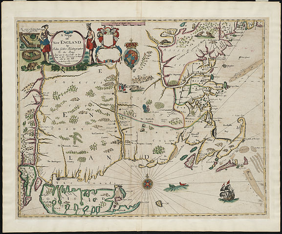
| Описание | Zoom into this map at maps.bpl.org. Author: Seller, John Publisher: And are to bee sold at his shop at the Hermitage in Wapping and by Iohn Hills in Exchange Alley in Cornhill Date: [1675] Location: New England Scale: Scale [ca. 1:1,170,000]. Call Number: G3720 1675.S451 A foundation in the early history of the mapping of New England, this map is the first printed version of William Reed's original survey of 1665. The survey was commissioned by Massachusetts authorities to support the colonial boundaries as described in the first Massachusetts Charter of 1628. As originally proposed, the northern boundary was located thirty miles north of the Merrimack River, assuming the river followed an east-west course. When it was later discovered that inland the Merrimack River turned north, Massachusetts colonists aggressively claimed lands thirty miles north of the rivers source, an area also claimed by New Hampshire. The survey is the earliest to depict the relative position of the Hudson, Connecticut and Merrimack rivers. Also identified on the map are several towns that had beendestroyed by Indians during the early months of King Philip's War. |
| Дата | |
| Источник | A mapp of New England / |
| Автор | http://maps.bpl.org |
Лицензирование
Этот файл доступен по лицензии Creative Commons Attribution 2.0 Generic
- Вы можете свободно:
- делиться произведением – копировать, распространять и передавать данное произведение
- создавать производные – переделывать данное произведение
- При соблюдении следующих условий:
- атрибуция – Вы должны указать авторство, предоставить ссылку на лицензию и указать, внёс ли автор какие-либо изменения. Это можно сделать любым разумным способом, но не создавая впечатление, что лицензиат поддерживает вас или использование вами данного произведения.
| Это изображение, изначально опубликованное на Flickr, было досмотрено 21 августа 2013 администратором или доверенным пользователем File Upload Bot (Magnus Manske), который подтвердил, что на тот момент оно было доступно на Flickr на условиях указанной лицензии. |
История файла
Нажмите на дату/время, чтобы посмотреть файл, который был загружен в тот момент.
| Дата/время | Миниатюра | Размеры | Участник | Примечание | |
|---|---|---|---|---|---|
| текущий | 04:37, 21 августа 2013 | | 2000 × 1665 (2,83 МБ) | File Upload Bot (Magnus Manske) | Transferred from Flickr by User:tm |
Использование файла
Следующая страница использует этот файл:
.jpg)