Файл:Sweden CIA map extended.gif

Повна роздільність (300 × 714 пікселів, розмір файлу: 21 КБ, MIME-тип: image/gif)
| Відомості про цей файл містяться на Вікісховищі — централізованому сховищі вільних файлів мультимедіа для використання у проектах Фонду Вікімедіа. |
Опис файлу
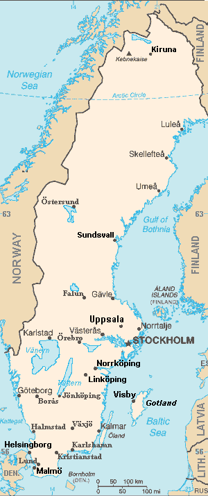
| Опис | Map of Sweden, extended from CIA World Fact Book, showing largest cities, islands and lake names. Larger city names (10) have been labeled with font-face Arial or Arial Narrow, as font-size 9 or 10; the island/region names are labeled in italic font. Sweden contains over 200 towns, but they are evenly dispersed around the main southern towns, except near Copenhagen, which has very high density. This map has locator code "SwedenCIAx" for use in map-locator templates, such as English Wiki Template:Location_map_SwedenCIAx & Template:Location_map_skew (which skews northern coordinates for multiple map markers/labels). The latitude/longitude coordinates are not equirectangular, but rather, narrow at the north, with longitudes about 38% closer together at the top. The narrowing longitudes provide more accurate mapping of area and distance than with rectangular coordinates. The original map image was public domain; the following modifications have been made to the original:
|
| Час створення | |
| Джерело | Derivative of map from User:Fred_J changing CIA map (Wikimedia Commons): Image:Sweden from cia.png (adding 10 labels, restoring color to CIA hues & magnified 15%) |
| Автор | Wikid77 (derivative of User:Fred_J form of CIA map, adding 10 labels) |
| Інші версії | This map has some variations:
|
Ліцензування
- Ви можете вільно:
- ділитися – копіювати, поширювати і передавати твір
- модифікувати – переробляти твір
- При дотриманні таких умов:
- зазначення авторства – Ви повинні вказати авторство, надати посилання на ліцензію і вказати, чи якісь зміни було внесено до оригінального твору. Ви можете зробити це в будь-який розсудливий спосіб, але так, щоб він жодним чином не натякав на те, наче ліцензіар підтримує Вас чи Ваш спосіб використання твору.
- поширення на тих же умовах – If you alter, transform, or build upon this work, you must distribute the resulting work under the same license as the original.
Цей файл є роботою працівника Центрального розвідувального управління, створеною для складання Всесвітньої книги фактів ЦРУ, тобто для виконання службових обов'язків. Як робота Федерального уряду США, цей файл перебуває в суспільному надбанні в США.
|  |
Format

This file is purposely maintained in GIF format (most international GIF-related patents have expired) for compatibility with the original CIA maps. Semi-automatic conversions to PNG-format might lose the color hues of the CIA maps, tending to shift to lighter blue and shift beige to white. A larger, detailed version of the map is being expanded, with more of the smaller 200 towns added.
Історія файлу
Клацніть на дату/час, щоб переглянути, як тоді виглядав файл.
| Дата/час | Мініатюра | Розмір об'єкта | Користувач | Коментар | |
|---|---|---|---|---|---|
| поточний | 18:44, 5 вересня 2007 | | 300 × 714 (21 КБ) | Wikid77 | completed east border of Sweden; enlarged "Helsingborg" & "Malmo" etc. |
| 12:33, 5 вересня 2007 |  | 300 × 714 (21 КБ) | Wikid77 | ==Summary== {{Information | Description= Map of Sweden, from CIA World Fact Book, with extensions for more town names and lakes. The original map image was public domain; the following modifications have been made to the original: * Drawing in lakes [[w:V |
Використання файлу
Така сторінка використовує цей файл:
Глобальне використання файлу
Цей файл використовують такі інші вікі:
- Використання в ar.wikipedia.org
- Використання в bn.wikipedia.org
- Використання в en.wikipedia.org
- User:Wikid77/Template:Location map skew
- User:Wikid77/Template:Location map skew/doc
- User:Wikid77/Template:Location map polarx
- User:Wikid77/Template:Location map polarx/doc
- User:Wikid77/Template:Location map SwedenCIAx
- Module talk:Location map/data/Sweden
- User:Wikid77/Template:Location map SwedenCIAskew
- Використання в kk.wikipedia.org
- Використання в kn.wikipedia.org
- Використання в ky.wikipedia.org
- Використання в mrj.wikipedia.org
- Використання в no.wikipedia.org
- Використання в ru.wikipedia.org
- Використання в yo.wikipedia.org