ファイル:Corrientes-oceanicas-en.svg
 ウィキペディアから無料の百科事典

この SVG ファイルのこの PNG プレビューのサイズ: 800 × 404 ピクセル. その他の解像度: 320 × 162 ピクセル | 640 × 323 ピクセル | 1,024 × 517 ピクセル | 1,280 × 647 ピクセル | 2,560 × 1,293 ピクセル | 976 × 493 ピクセル。
元のファイル (SVG ファイル、976 × 493 ピクセル、ファイルサイズ: 1.63メガバイト)
ウィキメディア・コモンズのファイルページにある説明を、以下に表示します。 |
概要
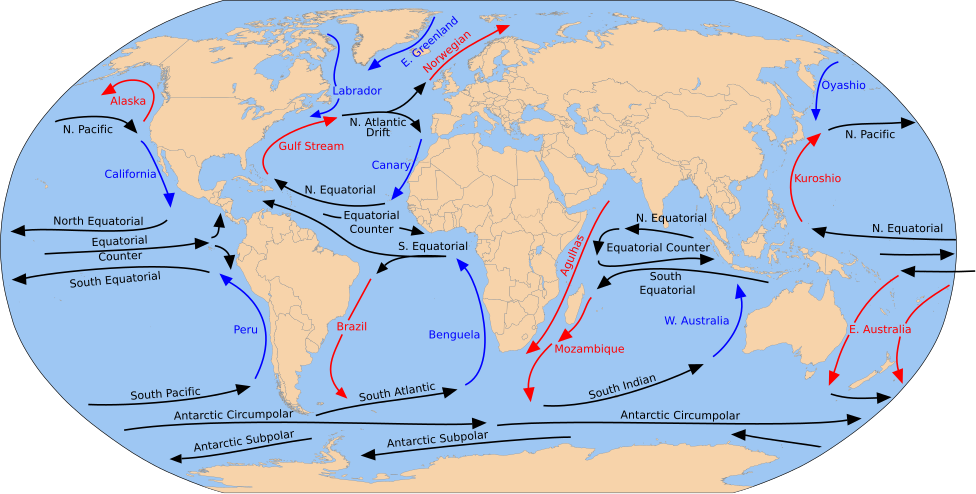
| 解説 | English: A detailed Robinson-projection SVG map with grouping enabled to connect all non-contiguous parts of a country's territory for easy colouring. Smaller countries can also be represented by larger circles to show their data easier. A thorough description of use and other instructions relating to can be found on the instruction page. |
| 日付 | (UTC) |
| 原典 | このファイルの派生元: Blank map of the world (Robinson projection) (10E).svg: このファイルの派生元: Corrientes-oceanicas.png: |
| 作者 |
|
_(10E).svg)
 | このSVGファイルには翻訳可能な埋め込みテキストが含まれています。SVG翻訳ツールや他のSVGエディタを使用して自分の言語に翻訳可能です。詳しくはSVGファイルの翻訳についてを参照してください。 |
ライセンス
この作品の著作権者である私は、この作品を以下のライセンスで提供します。
| この著作物の著作権者である私は、この著作物における権利を放棄しパブリックドメインとします。これは全世界で適用されます。 一部の国では、これが法的に可能ではない場合があります。その場合は、次のように宣言します。 私は、あらゆる人に対して、法により必要とされている条件を除き、如何なる条件も課すことなく、あらゆる目的のためにこの著作物を使用する権利を与えます。 |
元のアップロードログ
This image is a derivative work of the following images:
- File:Blank map of the world (Robinson projection) (10E).svg licensed with PD-self
- 2011-05-16T04:18:31Z Milenioscuro 3100x1600 (2087786 Bytes) {{Information |Description={{en|1=A detailed Robinson-projection [[Help:SVG|SVG]] map with grouping enabled to connect all non-contiguous parts of a country's territory for easy colouring. Smaller countries can also be repres
Uploaded with derivativeFX
ファイルの履歴
過去の版のファイルを表示するには、その版の日時をクリックしてください。
| 日付と時刻 | サムネイル | 寸法 | 利用者 | コメント | |
|---|---|---|---|---|---|
| 現在の版 | 2023年7月30日 (日) 17:43 | | 976 × 493 (1.63メガバイト) | Matěj Grabovský | File uploaded using svgtranslate tool (https://svgtranslate.toolforge.org/). Added translation for cs. |
| 2014年12月15日 (月) 18:08 |  | 976 × 493 (1.67メガバイト) | RicHard-59 | Guls -> Gulf | |
| 2014年4月28日 (月) 14:20 |  | 976 × 493 (1.58メガバイト) | Moja~commonswiki | Correct "Oyashia" -> "Oyashio" | |
| 2012年8月17日 (金) 14:51 |  | 976 × 493 (1.66メガバイト) | Popadius | Reverted to version as of 14:42, 17 August 2012 | |
| 2012年8月17日 (金) 14:49 |  | 976 × 493 (1.1メガバイト) | Popadius | small fix | |
| 2012年8月17日 (金) 14:42 |  | 976 × 493 (1.66メガバイト) | Popadius | == {{int:filedesc}} == {{Information |Description={{en|1=A detailed Robinson-projection SVG map with grouping enabled to connect all non-contiguous parts of a country's territory for easy colouring. Smaller countries can also be represente... |
ファイルの使用状況
グローバルなファイル使用状況
以下に挙げる他のウィキがこの画像を使っています:
- ca.wikipedia.org での使用状況
- cs.wikipedia.org での使用状況
- de.wikipedia.org での使用状況
- en.wikipedia.org での使用状況
- eo.wikipedia.org での使用状況
- es.wikipedia.org での使用状況
- eu.wikipedia.org での使用状況
- Ozeano Australa
- Golkoko itsaslasterra
- Humboldt itsaslasterra
- Agulhasko itsaslasterra
- Alaskako itsaslasterra
- Itsaslaster Zirkunpolar Antartikoa
- Antilletako itsaslasterra
- Benguelako itsaslasterra
- Brasilgo itsaslasterra
- Kaliforniako itsaslasterra
- Kanarietako itsaslasterra
- Floridako itsaslasterra
- Azoreetako itsaslasterra
- Karibeko itsaslasterra
- Cromwell itsaslasterra
- Ekialdeko Australiako itsaslasterra
- Groenlandiako ekialdeko itsaslasterra
- Madagaskarko ekialdeko itsaslasterra
- Malvinetako itsaslasterra
- Gineako itsaslasterra
- Irminger itsaslasterra
- Kuroshio itsaslasterra
- Oyashio itsaslasterra
- Labradorko itsaslasterra
- Leeuwingo itsaslasterra
- Lomonosov itsaslasterra
- Madagaskarko itsaslasterra
- Mindanaoko itsaslasterra
- Mozambikeko itsaslasterra
- Ipar Atlantikoko itsaslasterra
- Iparraldeko itsaslaster ekuatoriala
- Kontralaster Ekuatoriala
- Ipar Pazifikoko itsaslasterra
- Norvegiako itsaslasterra
- Portugalgo itsaslasterra
このファイルのグローバル使用状況を表示する。