ファイル:Drought Mitigation Decision Support System.png
 ウィキペディアから無料の百科事典
高解像度版はありません。
Drought_Mitigation_Decision_Support_System.png (650 × 442 ピクセル、ファイルサイズ: 30キロバイト、MIME タイプ: image/png)
ウィキメディア・コモンズのファイルページにある説明を、以下に表示します。 |
概要
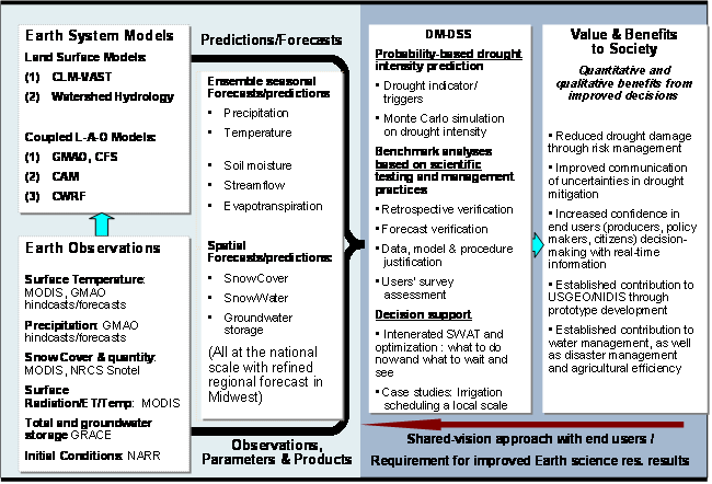
| 解説 | English: The goal of this project is to develop seasonal predictive capacity for the Drought Monitor-Decision Support System (DM-DSS), using Earth science models and satellite products. The DM-DSS was produced jointly by several national institutes, led by the National Drought Mitigation Center ( NDMC ) at the University of Nebraska-Lincoln. The Monitor presents a single, easy-to-read color map that summarizes current information from numerous drought indices and indicators. The enhanced DM-DSS with a predictive capacity will allow society's response to a drought from a traditional "crisis management" scenario, which emphasizes emergency response, to a "risk management" approach, which places greater emphasis on preparedness planning and mitigation actions. |
| 日付 | Last Modified: 04/15/09 |
| 原典 | http://wmp.gsfc.nasa.gov/projects/project_DroughtSeasPred.php |
| 作者 | NASA |
ライセンス
| このファイルはアメリカ航空宇宙局(NASA)によって作成されたものです。NASAの著作権の方針では、特記事項が無い場合、NASAの資料はパブリックドメインとなります。 (詳しくはTemplate:PD-USGov、NASAの著作権の方針について(英語)又はジェット推進研究所(JPL)の画像使用に関するガイドライン(英語)をご覧ください。) | ||
 | 注意事項:
|
ファイルの履歴
過去の版のファイルを表示するには、その版の日時をクリックしてください。
| 日付と時刻 | サムネイル | 寸法 | 利用者 | コメント | |
|---|---|---|---|---|---|
| 現在の版 | 2009年6月17日 (水) 11:33 | | 650 × 442 (30キロバイト) | Mdd | {{Information |Description={{en|1=The goal of this project is to develop seasonal predictive capacity for the Drought Monitor-Decision Support System (DM-DSS), using Earth science models and satellite products. The DM-DSS was produced jointly by several n |
ファイルの使用状況
以下のページがこのファイルを使用しています:
グローバルなファイル使用状況
以下に挙げる他のウィキがこの画像を使っています:
- ar.wikipedia.org での使用状況
- el.wikipedia.org での使用状況
- en.wikipedia.org での使用状況
- sr.wikipedia.org での使用状況