ファイル:English unitary authorities 2009.svg
 ウィキペディアから無料の百科事典

この SVG ファイルのこの PNG プレビューのサイズ: 494 × 600 ピクセル. その他の解像度: 198 × 240 ピクセル | 395 × 480 ピクセル | 633 × 768 ピクセル | 844 × 1,024 ピクセル | 1,687 × 2,048 ピクセル | 1,039 × 1,261 ピクセル。
元のファイル (SVG ファイル、1,039 × 1,261 ピクセル、ファイルサイズ: 1メガバイト)
ウィキメディア・コモンズのファイルページにある説明を、以下に表示します。 |
概要
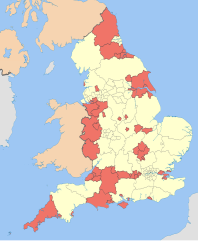
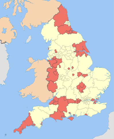
| 解説 | English: Map showing the unitary authorities of England highlighted, together with the all the other top-tier administrative subdivisions (shire counties, metropolitan counties, and London boroughs) from 2009 (still valid in 2012).
Equirectangular map projection on WGS 84 datum, with N/S stretched 170% Geographic limits:
|
| 日付 | (UTC) |
| 原典 | このファイルの派生元: English administrative divisions 2010.svg:  |
| 作者 |
|
| その他のバージョン |
この画像には画像編集が施されています。原本に対して次のデジタル的な変更が行われました。
|
ライセンス
この作品の著作権者である私は、この作品を以下のライセンスで提供します。
このファイルはクリエイティブ・コモンズ 表示-継承 3.0 非移植ライセンスのもとに利用を許諾されています。
帰属: Nilfanion and Dr Greg
- あなたは以下の条件に従う場合に限り、自由に
- 共有 – 本作品を複製、頒布、展示、実演できます。
- 再構成 – 二次的著作物を作成できます。
- あなたの従うべき条件は以下の通りです。
- 表示 – あなたは適切なクレジットを表示し、ライセンスへのリンクを提供し、変更があったらその旨を示さなければなりません。これらは合理的であればどのような方法で行っても構いませんが、許諾者があなたやあなたの利用行為を支持していると示唆するような方法は除きます。
- 継承 – もしあなたがこの作品をリミックスしたり、改変したり、加工した場合には、あなたはあなたの貢献部分を元の作品とこれと同一または互換性があるライセンスの下に頒布しなければなりません。
 | この文書は、フリーソフトウェア財団発行のGNUフリー文書利用許諾書 (GNU Free Documentation License) 1.2またはそれ以降のバージョンの規約に基づき、複製や再配布、改変が許可されます。不可変更部分、表紙、背表紙はありません。このライセンスの複製は、GNUフリー文書利用許諾書という章に含まれています。 |
あなたは上記のライセンスから、どれか一つ以上を選択できます。
元のアップロードログ
This image is a derivative work of the following images:
- File:English_administrative_divisions_2010.svg licensed with Cc-by-sa-3.0, GFDL
- 2010-11-23T22:02:28Z Nilfanion 1108x1345 (374390 Bytes) England only
- 2010-11-23T22:00:33Z Nilfanion 1108x1345 (410564 Bytes) {{Information |Description=Map showing the all top-tier administrative subdivisions of England (shire counties, metropolitan counties, London boroughs and Unitary Authorities) in 2010 Equirectangular map projection on WGS 84
Uploaded with derivativeFX
ファイルの履歴
過去の版のファイルを表示するには、その版の日時をクリックしてください。
| 日付と時刻 | サムネイル | 寸法 | 利用者 | コメント | |
|---|---|---|---|---|---|
| 現在の版 | 2019年4月8日 (月) 23:50 | | 1,039 × 1,261 (1メガバイト) | The Equalizer | Prior image had cropped sides |
| 2019年4月8日 (月) 23:47 |  | 744 × 1,052 (1メガバイト) | The Equalizer | Prior upload not displaying | |
| 2019年4月8日 (月) 23:04 |  | 1,108 × 1,345 (204キロバイト) | The Equalizer | Updated UAs in Dorset | |
| 2012年5月6日 (日) 12:23 |  | 1,108 × 1,345 (380キロバイト) | Dr Greg | paler boundary lines | |
| 2012年3月20日 (火) 22:17 |  | 1,108 × 1,345 (376キロバイト) | Dr Greg | == {{int:filedesc}} == {{Information |Description={{en|1=Map showing the en:unitary authorities of England highlighted, together with the all the other top-tier administrative subdivisions (shire counties, metropolitan counties, and London boroug... |
ファイルの使用状況
以下の 10 ページがこのファイルを使用しています:
グローバルなファイル使用状況
以下に挙げる他のウィキがこの画像を使っています:
- af.wikipedia.org での使用状況
- fr.wikipedia.org での使用状況
- hr.wikipedia.org での使用状況
- it.wikipedia.org での使用状況
- ko.wikipedia.org での使用状況
- no.wikipedia.org での使用状況
- oc.wikipedia.org での使用状況
- sh.wikipedia.org での使用状況