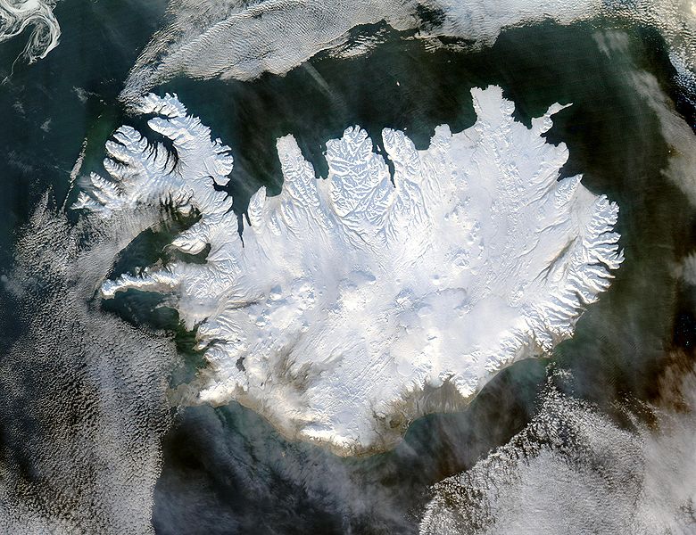
ファイル:Iceland satellite.jpg

ウィキペディアから無料の百科事典

元のファイル(2,600 × 2,000 ピクセル、ファイルサイズ: 869キロバイト、MIME タイプ: image/jpeg)

ウィキペディア

 このファイルはトルコ語版ウィキペディアで秀逸な画像 (Seçkin resimler) であり、 もっとも質の高い画像のひとつだと評価されています。

あなたが、このファイルはウィキメディア・コモンズでも秀逸と評価されるべきだ、とお考えなら、自由に推薦してください。
もしあなたが同じくらい品質が高く、適切なライセンスの下に公開できるファイルをお持ちならば、ぜひアップロードして、著作権情報を表示し、推薦しましょう。

概要

解説
English: Iceland, from the NASA Visible Earth image gallery. More info below
Deutsch: Satellitenbild Islands aus der NASA-Fotogallerie Visible Earth. Mehr Information untenstehend auf Englisch.
Українська: Супутниковий знімок Ісландії, 29 січня 2004 року.
日付 2004年1月29日
原典 http://veimages.gsfc.nasa.gov/6605/Iceland.A2004028.1355.250m.jpg
作者 Jeff Schmaltz
許可
(ファイルの再利用)
Public domain このファイルはアメリカ航空宇宙局(NASA)によって作成されたものです。NASAの著作権の方針では、特記事項が無い場合、NASAの資料はパブリックドメインとなります。
(詳しくはTemplate:PD-USGovNASAの著作権の方針について(英語)又はジェット推進研究所(JPL)の画像使用に関するガイドライン(英語)をご覧ください。)
注意事項:

Picture info

  • Description and alternative versions http://visibleearth.nasa.gov/view_rec.php?id=6605
  • Metadata: Sensor Aqua/MODIS
  • Visualization Date: 2004-01-29
  • Credit: Jeff Schmaltz, MODIS Rapid Response Team, NASA/GSFC
  • Description: Iceland lives up to its name in this image, acquired by the Moderate Resolution Imaging Spectroradiometer (MODIS) on NASA's Terra satellite on January 28, 2004. The island country is completely covered in white snow and ice, obscuring the permanent glaciers and icecaps that exist year-round. The effect of ice on this island sandwiched between the North Atlantic and the Greenland Sea, just below the Arctic Circle, is visible along its rugged northern shores. Over millennia, ice has carved out deep fjords leaving fringes of land that extend like fingers into the ocean.
  • Source: ”The purpose of NASA's Earth Observatory is to provide a freely-accessible publication on the Internet where the public can obtain new satellite imagery and scientific information about our home planet. The focus is on Earth's climate and environmental change. In particular, we hope our site is useful to public media and educators. Any and all materials published on the Earth Observatory are freely available for re-publication or re-use, except where copyright is indicated. We ask that NASA's Earth Observatory be given credit for its original materials.”

キャプション

このファイルの内容を1行で記述してください

このファイルに描写されている項目

題材

29 1 2004

ファイルの履歴

過去の版のファイルを表示するには、その版の日時をクリックしてください。

日付と時刻サムネイル寸法利用者コメント
現在の版2004年12月5日 (日) 05:492004年12月5日 (日) 05:49時点における版のサムネイル2,600 × 2,000 (869キロバイト)Ævar Arnfjörð Bjarmasonbigger version
2004年11月6日 (土) 12:062004年11月6日 (土) 12:06時点における版のサムネイル540 × 405 (68キロバイト)RanveigNASA satelite image of Iceland

以下の​ 2 ページがこのファイルを使用しています:

グローバルなファイル使用状況

以下に挙げる他のウィキがこの画像を使っています:

このファイルのグローバル使用状況を表示する。

メタデータ