ファイル:Jaén-loc.svg
 ウィキペディアから無料の百科事典

この SVG ファイルのこの PNG プレビューのサイズ: 512 × 374 ピクセル. その他の解像度: 320 × 234 ピクセル | 640 × 468 ピクセル | 1,024 × 748 ピクセル | 1,280 × 935 ピクセル | 2,560 × 1,870 ピクセル。
元のファイル (SVG ファイル、512 × 374 ピクセル、ファイルサイズ: 429キロバイト)
ウィキメディア・コモンズのファイルページにある説明を、以下に表示します。 |
概要
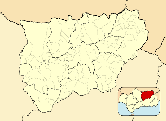
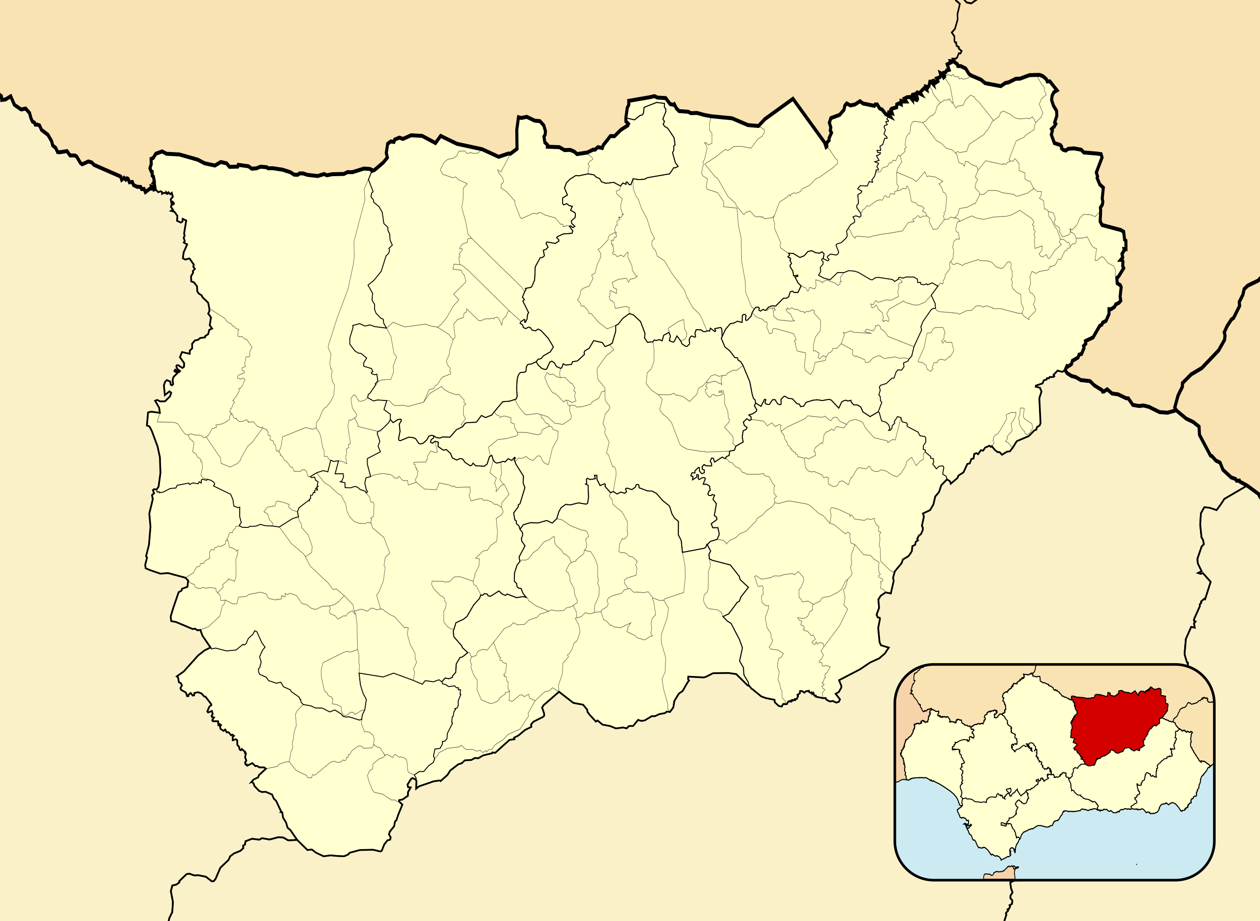
| 解説 | English: Location map of Province of Jaén Equirectangular projection, N/S stretching 130 %. Geographic limits of the map:
Español: Mapa de localización de Provincia de Jaén Proyección equirrectangular, N/S estirada 130 %. Límites geográficos del mapa:
| |
| 日付 | ||
| 原典 | 次の画像を基にした投稿者自身による著作物: EspañaLoc.svg 次のものによる: HansenBCNおよび;Spain location map.svg 次のものによる: NNW | |
| 作者 | Miguillen | |
| SVG 開発 |
|
ライセンス
この作品の著作権者であるMiguillenは、この作品を以下のライセンスで提供しています。
このファイルはクリエイティブ・コモンズ 表示-継承 3.0 非移植ライセンスのもとに利用を許諾されています。
帰属: Miguillen
- あなたは以下の条件に従う場合に限り、自由に
- 共有 – 本作品を複製、頒布、展示、実演できます。
- 再構成 – 二次的著作物を作成できます。
- あなたの従うべき条件は以下の通りです。
- 表示 – あなたは適切なクレジットを表示し、ライセンスへのリンクを提供し、変更があったらその旨を示さなければなりません。これらは合理的であればどのような方法で行っても構いませんが、許諾者があなたやあなたの利用行為を支持していると示唆するような方法は除きます。
- 継承 – もしあなたがこの作品をリミックスしたり、改変したり、加工した場合には、あなたはあなたの貢献部分を元の作品とこれと同一または互換性があるライセンスの下に頒布しなければなりません。
ファイルの履歴
過去の版のファイルを表示するには、その版の日時をクリックしてください。
| 日付と時刻 | サムネイル | 寸法 | 利用者 | コメント | |
|---|---|---|---|---|---|
| 現在の版 | 2010年12月8日 (水) 15:51 | | 512 × 374 (429キロバイト) | Miguillen | colores |
| 2010年12月8日 (水) 12:58 |  | 512 × 374 (432キロバイト) | Miguillen | adapto a nueva convención | |
| 2010年6月10日 (木) 09:19 |  | 512 × 374 (336キロバイト) | Miguillen | == {{int:filedesc}} == {{Information |Description= {{en|Location map of Province of Jaén}} Equirectangular projection, N/S stretching 130 %. Geographic limits of the map: * N: 43.469909° N * S: 41.829151° N * W: 2.625855° |
ファイルの使用状況
以下の 11 ページがこのファイルを使用しています:
グローバルなファイル使用状況
以下に挙げる他のウィキがこの画像を使っています:
- ar.wikipedia.org での使用状況
- ast.wikipedia.org での使用状況
- ba.wikipedia.org での使用状況
- ceb.wikipedia.org での使用状況
- de.wikipedia.org での使用状況
- en.wikipedia.org での使用状況
- Andújar
- Quesada, Spain
- Bailén
- Porcuna
- Linares, Jaén
- Torreperogil
- Segura de la Sierra
- Albanchez de Mágina
- Alcalá la Real
- Aldeaquemada
- Arjonilla
- Arquillos
- Arroyo del Ojanco
- Baños de la Encina
- Beas de Segura
- Bedmar y Garcíez
- Begíjar
- Bélmez de la Moraleda
- Cabra del Santo Cristo
- Cambil
- Carboneros
- Cárcheles
- La Carolina
- Castillo de Locubín
- Cazalilla
- Chiclana de Segura
- Chilluévar
- Escañuela
- Espeluy
- Fuensanta de Martos
- Fuerte del Rey
- La Guardia de Jaén
- Guarromán
- Hinojares
- Hornos
- Huelma
- Huesa
- La Iruela
- Iznatoraf
- Jabalquinto
- Jamilena
- Jódar
- Lahiguera
このファイルのグローバル使用状況を表示する。