ファイル:Kosovo02.png
 ウィキペディアから無料の百科事典
このプレビューのサイズ: 546 × 599 ピクセル。 その他の解像度: 219 × 240 ピクセル | 437 × 480 ピクセル | 770 × 845 ピクセル。
元のファイル (770 × 845 ピクセル、ファイルサイズ: 76キロバイト、MIME タイプ: image/png)
ウィキメディア・コモンズのファイルページにある説明を、以下に表示します。 |
概要
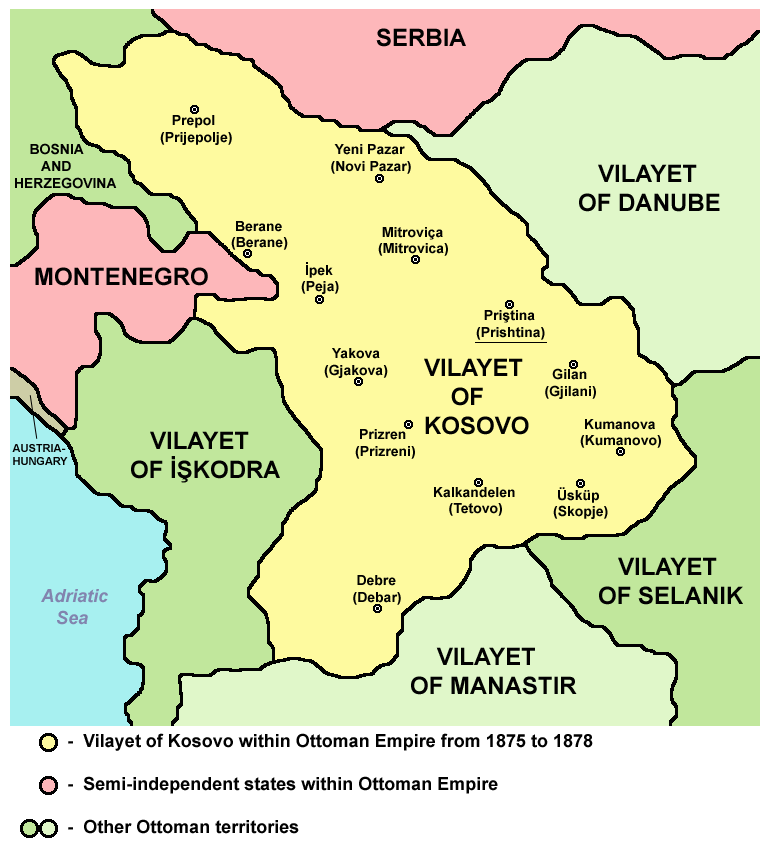
Vilayet of Kosovo within Ottoman Empire from 1875 to 1878.
Source and licence
 | This map has been uploaded by Electionworld from en.wikipedia.org to enable the |
| この著作物は、著作者であるPANONIANによって権利が放棄され、パブリックドメインとされました。これは全世界で適用されます。 一部の国では、これが法的に可能ではない場合があります。その場合は、次のように宣言します。 |
References
Main reference:
- Created according to historical map from this book: Petrit Imami, Srbi i Albanci kroz vekove, Beograd, 2000.
Secondary references with similar maps:
- http://kosova.org/pics/maps/kosova_1878b.jpg
- http://img254.imageshack.us/img254/5316/shqiprian1878ye3.jpg
- http://www.tlfq.ulaval.ca/axl/europe/images/albanie-vilayets-map.gif
ファイルの履歴
過去の版のファイルを表示するには、その版の日時をクリックしてください。
| 日付と時刻 | サムネイル | 寸法 | 利用者 | コメント | |
|---|---|---|---|---|---|
| 現在の版 | 2012年9月11日 (火) 12:46 | | 770 × 845 (76キロバイト) | PANONIAN | cosmetic changes |
| 2011年4月6日 (水) 07:16 |  | 692 × 808 (62キロバイト) | PANONIAN | Reverted to version as of 08:40, 5 April 2011 - trying to solve thumbnail problem | |
| 2011年4月6日 (水) 07:15 |  | 692 × 808 (64キロバイト) | PANONIAN | Reverted to version as of 19:07, 2 June 2009 - trying to solve thumbnail problem | |
| 2011年4月5日 (火) 08:40 |  | 692 × 808 (62キロバイト) | PANONIAN | aesthetical improvement | |
| 2009年6月2日 (火) 19:07 |  | 692 × 808 (64キロバイト) | PANONIAN | ||
| 2009年6月2日 (火) 16:30 |  | 692 × 808 (65キロバイト) | PANONIAN | ||
| 2008年1月29日 (火) 23:37 |  | 626 × 614 (200キロバイト) | Mahahahaneapneap | pngcrushed | |
| 2006年12月21日 (木) 23:32 |  | 626 × 614 (221キロバイト) | Electionworld | {{ew|en|PANONIAN}} {{PD-user|PANONIAN}} Category:Maps of Kosovo |
ファイルの使用状況
グローバルなファイル使用状況
以下に挙げる他のウィキがこの画像を使っています:
- af.wikipedia.org での使用状況
- az.wikipedia.org での使用状況
- be.wikipedia.org での使用状況
- bg.wikipedia.org での使用状況
- bn.wikipedia.org での使用状況
- br.wikipedia.org での使用状況
- bs.wikipedia.org での使用状況
- ca.wikipedia.org での使用状況
- ckb.wikipedia.org での使用状況
- cs.wikipedia.org での使用状況
- da.wikipedia.org での使用状況
- de.wikipedia.org での使用状況
- el.wikipedia.org での使用状況
- en.wikipedia.org での使用状況
- es.wikipedia.org での使用状況
- et.wikipedia.org での使用状況
- fi.wikipedia.org での使用状況
- fr.wikipedia.org での使用状況
- fy.wikipedia.org での使用状況
- gl.wikipedia.org での使用状況
- he.wikipedia.org での使用状況
- hr.wikipedia.org での使用状況
- ht.wikipedia.org での使用状況
- hu.wikipedia.org での使用状況
- io.wikipedia.org での使用状況
- it.wikipedia.org での使用状況
- lt.wikipedia.org での使用状況
- lv.wikipedia.org での使用状況
- mk.wikipedia.org での使用状況
- nl.wikipedia.org での使用状況
- no.wikipedia.org での使用状況
- nrm.wikipedia.org での使用状況
- pl.wikipedia.org での使用状況
このファイルのグローバル使用状況を表示する。