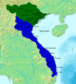
ファイル:Map of Southern and Northern Dynasties of Vietnam.png
 ウィキペディアから無料の百科事典

元のファイル (650 × 800 ピクセル、ファイルサイズ: 124キロバイト、MIME タイプ: image/png)
ファイルの履歴
過去の版のファイルを表示するには、その版の日時をクリックしてください。
| 日付と時刻 | サムネイル | 寸法 | 利用者 | コメント | |
|---|---|---|---|---|---|
| 現在の版 | 2020年5月19日 (火) 11:17 |  | 650 × 800 (124キロバイト) | A | Upload a to a new name if you want, but don't replace files of other people |
| 2020年5月17日 (日) 00:54 |  | 764 × 843 (694キロバイト) | Zhu Zi Ling | Cities and town added | |
| 2015年9月29日 (火) 19:14 |  | 650 × 800 (124キロバイト) | Denniss | Reverted to version as of 17:11, 25 December 2014 | |
| 2015年9月28日 (月) 13:04 |  | 650 × 800 (82キロバイト) | 昭文館 | =={{int:filedesc}}== {{Information |description={{en|1=Vietnam circa 1570 showing the Mac in control of the land north of the Red river, and the Nguyen-Trinh alliance in control of the southern part of Vietnam. Map data based on "The Empire of Le Than... | |
| 2014年12月25日 (木) 17:11 |  | 650 × 800 (124キロバイト) | TRMC | User created page with UploadWizard |
ファイルの使用状況
以下のページがこのファイルを使用しています:
グローバルなファイル使用状況
以下に挙げる他のウィキがこの画像を使っています:
- bn.wikipedia.org での使用状況
- ceb.wikipedia.org での使用状況
- de.wikipedia.org での使用状況
- en.wikipedia.org での使用状況
- fr.wikipedia.org での使用状況
- id.wikipedia.org での使用状況
- it.wikipedia.org での使用状況
- ko.wikipedia.org での使用状況
- pt.wikipedia.org での使用状況
- sl.wikipedia.org での使用状況
- uk.wikipedia.org での使用状況
- vi.wikipedia.org での使用状況
- www.wikidata.org での使用状況
- zh.wikipedia.org での使用状況