ファイル:NorthAmerica1762-83.png

ウィキペディアから無料の百科事典

NorthAmerica1762-83.png(787 × 600 ピクセル、ファイルサイズ: 90キロバイト、MIME タイプ: image/png)

このhistorical map画像は、ベクターイメージである SVG ファイルとして再作成されるべきです。これにはいくつかの利点があります。詳しくはCommons:Media for cleanupを参照してください。この画像の SVG 形式がすでに利用可能である場合は、アップロードしてください。アップロード後、この画像にあるこのテンプレートを{{Vector version available|新しい画像ファイル名.svg}}テンプレートで置き換えてください。

概要

解説
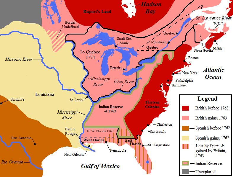
English: Map showing territorial gains of Britain and Spain following the French and Indian War.

Also shown are boundary changes within the territory the British had acquired between 1763 to 1783.

Territorial lands held by the British before 1763 is shown in red, land gained by Britain in 1763 is shown in pink.

The lands ceded to the Kingdom of Spain in secret during 1762 are in light yellow, and also set-off are the lands Britain promised to close to white settlement - a causus belli to many Americans leading to support for the American Revolution.
このhistorical map画像は、ベクターイメージである SVG ファイルとして再作成されるべきです。これにはいくつかの利点があります。詳しくはCommons:Media for cleanupを参照してください。この画像の SVG 形式がすでに利用可能である場合は、アップロードしてください。アップロード後、この画像にあるこのテンプレートを{{Vector version available|新しい画像ファイル名.svg}}テンプレートで置き換えてください。
日付
原典 投稿者自身による著作物 ( Base map used is found here, uploaded by Roke )
作者 Jon Platek
その他のバージョン العربيَّة

ライセンス

この作品の著作権者である私は、この作品を以下のライセンスで提供します。
w:ja:クリエイティブ・コモンズ
表示 継承
このファイルはクリエイティブ・コモンズ 表示-継承 3.0 非移植ライセンスのもとに利用を許諾されています。
あなたは以下の条件に従う場合に限り、自由に
  • 共有 – 本作品を複製、頒布、展示、実演できます。
  • 再構成 – 二次的著作物を作成できます。
あなたの従うべき条件は以下の通りです。
  • 表示 – あなたは適切なクレジットを表示し、ライセンスへのリンクを提供し、変更があったらその旨を示さなければなりません。これらは合理的であればどのような方法で行っても構いませんが、許諾者があなたやあなたの利用行為を支持していると示唆するような方法は除きます。
  • 継承 – もしあなたがこの作品をリミックスしたり、改変したり、加工した場合には、あなたはあなたの貢献部分を元の作品とこれと同一または互換性があるライセンスの下に頒布しなければなりません。
GNU head この文書は、フリーソフトウェア財団発行のGNUフリー文書利用許諾書 (GNU Free Documentation License) 1.2またはそれ以降のバージョンの規約に基づき、複製や再配布、改変が許可されます。不可変更部分、表紙、背表紙はありません。このライセンスの複製は、GNUフリー文書利用許諾書という章に含まれています。
あなたは上記のライセンスから、どれか一つ以上を選択できます。

Notes

  • The pink coloring specifically designates territory that Britain held without question after 1763; included are both areas that had been under full Spanish or French control and then lost, as well as areas disputedly claimed by Britain before 1763.
  • The undefined boundary in the upper watershed of the Red River of the North was due to confusion at the time as to the location of the headwaters of the Mississippi River. (The source of the Mississippi was believed to have been further north than its actual location.)
  • Dashed lines designate border changes within British-held territory outside of the thirteen colonies between 1763 and 1783.
    • Both of the annexations shown, by West Florida in 1767 and by Quebec in 1774, were previously included in the Indian Reserve of 1763. The Indian Reserve boundaries shown on the map are only the boundaries of the reserve until 1783, except for adjustments to the boundary made by the 1768 Treaty of Fort Stanwix and other treaties, which are not shown.

CORRECTION that needs to be made: Nova Scotia is wrongly labelled. What is currently now Nova Scotia (and which includes what was then Acadia) is only the area indicated by the rightmost of the two indicator lines. The left area is pointing to what is now New Brunswick. These names and areas did not exist at that time. The area that is now Canada should be treated the same as the area that was the American colonies: show and label only the cities and towns, and do not provide labels for the currently existing states and provinces (i.e., the current individual American states are not labelled, so why are only two of the provinces labelled (and mislabelled at that)?).

キャプション

このファイルの内容を1行で記述してください
North America after the Seven Years' War. France ceded Louisiana to Spain before surrender; this kept Britain out of the trans-Mississippi West. Spain traded Florida for Cuba. Britain created two colonies with captials at Pensacola & St. Augustine.

このファイルに描写されている項目

題材

28 9 2008

ファイルの履歴

過去の版のファイルを表示するには、その版の日時をクリックしてください。

日付と時刻サムネイル寸法利用者コメント
現在の版2011年9月5日 (月) 05:172011年9月5日 (月) 05:17時点における版のサムネイル787 × 600 (90キロバイト)Creysmon07Changing contours of the lakes and the coasts of North America (made manually).
2008年9月28日 (日) 21:052008年9月28日 (日) 21:05時点における版のサムネイル787 × 600 (62キロバイト)AlexiusHoratius~commonswiki{{Information |Description={{en|1=Map showing territorial gains of Britain and Spain following the French and Indian War. Also shown are boundary changes within the territory the British had aquired between 1763 to 1783.}} |Source=Own work by uploader |Au

グローバルなファイル使用状況

以下に挙げる他のウィキがこの画像を使っています:

このファイルのグローバル使用状況を表示する。