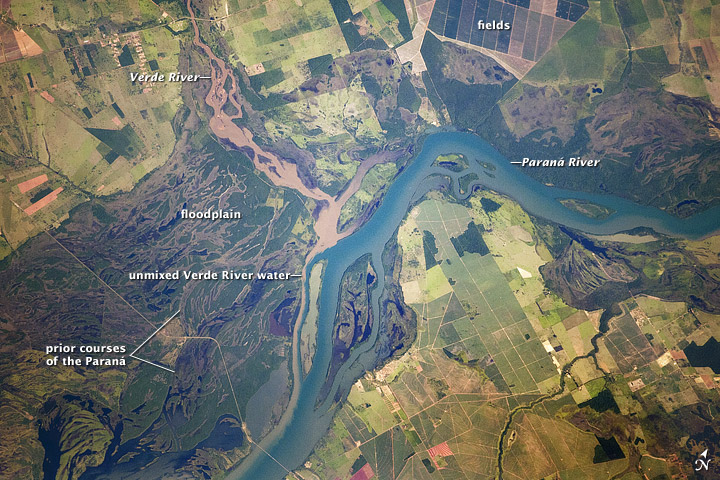
ファイル:Paraná River Floodplain.jpg
 ウィキペディアから無料の百科事典
Paraná_River_Floodplain.jpg (720 × 480 ピクセル、ファイルサイズ: 179キロバイト、MIME タイプ: image/jpeg)
ファイルの履歴
過去の版のファイルを表示するには、その版の日時をクリックしてください。
| 日付と時刻 | サムネイル | 寸法 | 利用者 | コメント | |
|---|---|---|---|---|---|
| 現在の版 | 2012年3月22日 (木) 18:28 |  | 720 × 480 (179キロバイト) | Tillman | {{Information |Description ={{en|1=Paraná River Floodplain, Brazil The Paraná River appears as a wide, blue strip with the muddy brown water of the smaller Verde River entering from the northwest (top left). An extensive wetland (dark green) occu... |
ファイルの使用状況
以下のページがこのファイルを使用しています:
グローバルなファイル使用状況
以下に挙げる他のウィキがこの画像を使っています:
- ba.wikipedia.org での使用状況
- bh.wikipedia.org での使用状況
- bn.wikipedia.org での使用状況
- ca.wikipedia.org での使用状況
- din.wikipedia.org での使用状況
- en.wikipedia.org での使用状況
- eo.wikipedia.org での使用状況
- fi.wikipedia.org での使用状況
- sl.wikipedia.org での使用状況
- sr.wikipedia.org での使用状況
- uk.wikipedia.org での使用状況
- vi.wikipedia.org での使用状況
- war.wikipedia.org での使用状況
- www.wikidata.org での使用状況
- zh.wikipedia.org での使用状況


