ファイル:Pyrenees Mountains view from satellite.jpg
 ウィキペディアから無料の百科事典

このプレビューのサイズ: 780 × 600 ピクセル。 その他の解像度: 312 × 240 ピクセル | 624 × 480 ピクセル | 999 × 768 ピクセル | 1,280 × 985 ピクセル | 2,600 × 2,000 ピクセル。
元のファイル (2,600 × 2,000 ピクセル、ファイルサイズ: 877キロバイト、MIME タイプ: image/jpeg)
ウィキメディア・コモンズのファイルページにある説明を、以下に表示します。 |
概要
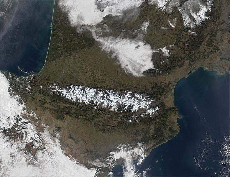
| 解説 | The Pyrenees Mountains (center) act as a natural border between France to the north and Spain to the south. In this MODIS image from January 18, 2002, they are covered in snow (bright red in the false-color image.) At upper left, contrails are visible over the Bay of Biscay, which, along the French shores, sport miles and miles of white sandy beaches. |
| 日付 | |
| 原典 | http://visibleearth.nasa.gov/view_rec.php?id=2690 |
| 作者 | Jacques Descloitres, MODIS Land Rapid Response Team, NASA/GSFC |
ライセンス
| このファイルはアメリカ航空宇宙局(NASA)によって作成されたものです。NASAの著作権の方針では、特記事項が無い場合、NASAの資料はパブリックドメインとなります。 (詳しくはTemplate:PD-USGov、NASAの著作権の方針について(英語)又はジェット推進研究所(JPL)の画像使用に関するガイドライン(英語)をご覧ください。) | ||
 | 注意事項:
|
ファイルの履歴
過去の版のファイルを表示するには、その版の日時をクリックしてください。
| 日付と時刻 | サムネイル | 寸法 | 利用者 | コメント | |
|---|---|---|---|---|---|
| 現在の版 | 2004年12月3日 (金) 20:30 | | 2,600 × 2,000 (877キロバイト) | Alfio | pyrenees mountains seen from satellite |
ファイルの使用状況
以下の 2 ページがこのファイルを使用しています:
グローバルなファイル使用状況
以下に挙げる他のウィキがこの画像を使っています:
- an.wikipedia.org での使用状況
- ast.wikipedia.org での使用状況
- ca.wikipedia.org での使用状況
- cs.wikipedia.org での使用状況
- es.wikipedia.org での使用状況
- eu.wikipedia.org での使用状況
- ext.wikipedia.org での使用状況
- fi.wikipedia.org での使用状況
- gl.wikipedia.org での使用状況
- he.wikipedia.org での使用状況
- it.wikipedia.org での使用状況
- kk.wikipedia.org での使用状況
- la.wiktionary.org での使用状況
- lfn.wikipedia.org での使用状況
- nl.wikipedia.org での使用状況
- oc.wikipedia.org での使用状況
- oc.wiktionary.org での使用状況
- pl.wiktionary.org での使用状況
- pms.wikipedia.org での使用状況
- pt.wikipedia.org での使用状況
- qu.wikipedia.org での使用状況
- war.wikipedia.org での使用状況
- zh-min-nan.wikipedia.org での使用状況