ファイル:Regional Internet Registries world map.svg
 ウィキペディアから無料の百科事典

この SVG ファイルのこの PNG プレビューのサイズ: 800 × 353 ピクセル. その他の解像度: 320 × 141 ピクセル | 640 × 283 ピクセル | 1,024 × 452 ピクセル | 1,280 × 565 ピクセル | 2,560 × 1,130 ピクセル | 940 × 415 ピクセル。
元のファイル (SVG ファイル、940 × 415 ピクセル、ファイルサイズ: 1.48メガバイト)
ウィキメディア・コモンズのファイルページにある説明を、以下に表示します。 |
概要
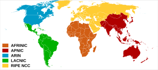
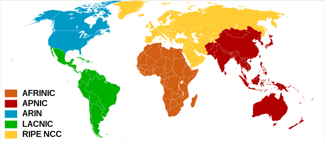
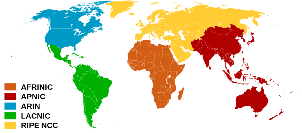
| 解説 | العربية: خريطة العالم بحسب سجلات الإنترنت الإقليمية. English: Regional Internet Registries world map. Español: Mapa de Registros Regionales de Internet. Français : Carte du monde des organisations de registre Internet régional. |
| 日付 | (UTC) |
| 原典 | |
| 作者 | |
| その他のバージョン |  |
ライセンス
このファイルはクリエイティブ・コモンズ 表示-継承 3.0 非移植ライセンスのもとに利用を許諾されています。
- あなたは以下の条件に従う場合に限り、自由に
- 共有 – 本作品を複製、頒布、展示、実演できます。
- 再構成 – 二次的著作物を作成できます。
- あなたの従うべき条件は以下の通りです。
- 表示 – あなたは適切なクレジットを表示し、ライセンスへのリンクを提供し、変更があったらその旨を示さなければなりません。これらは合理的であればどのような方法で行っても構いませんが、許諾者があなたやあなたの利用行為を支持していると示唆するような方法は除きます。
- 継承 – もしあなたがこの作品をリミックスしたり、改変したり、加工した場合には、あなたはあなたの貢献部分を元の作品とこれと同一または互換性があるライセンスの下に頒布しなければなりません。
元のアップロードログ
This image is a derivative work of the following images:
- File:Rir.gif licensed with Cc-by-sa-2.5, Cc-by-sa-2.5/en
- 2006-04-02T01:24:59Z Dork 300x163 (3093 Bytes) Regional Internet Registries (containing AFRINIC)
- File:BlankMap-World6,_compact.svg licensed with PD-self, PD-self/en
- 2008-12-02T18:21:18Z Lokal Profil 940x415 (1518276 Bytes) Reverted to version as of 14:51, 13 June 2008, new image has non of the complexity (i.e. colouring abilities etc.) of the old
- 2008-12-02T17:29:39Z Harbin 1326x601 (176022 Bytes)
- 2008-12-02T17:26:08Z Harbin 1425x625 (189017 Bytes)
- 2008-06-13T14:51:25Z Lokal Profil 940x415 (1518276 Bytes) Syncing with [[:Image:BlankMap-World6.svg]] version (01:30, March 29, 2008). Sadly enough the validator does not seem to like rdf element of the metadata although it should work acording to http://www.w3schools.com/rdf/rdf_ma
- 2008-02-08T20:55:35Z CarolSpears 940x415 (1528750 Bytes) validated, maybe
- 2007-12-14T19:51:17Z Lokal Profil 940x415 (1529675 Bytes) Readded an ocean object but this one is square instead of the original elliptic one
- 2007-12-14T19:19:56Z Lokal Profil 940x415 (1529845 Bytes) {{Information |Description=Detailed SVG map with grouping enabled to connect all non-contiguous parts of a country's territory for easy colouring. Smaller countries can also be represented by larger circles to show their data
Uploaded with derivativeFX
ファイルの履歴
過去の版のファイルを表示するには、その版の日時をクリックしてください。
| 日付と時刻 | サムネイル | 寸法 | 利用者 | コメント | |
|---|---|---|---|---|---|
| 現在の版 | 2020年2月8日 (土) 08:57 | | 940 × 415 (1.48メガバイト) | Rauisuchian | Corrected name to AFRINIC, all capitalized |
| 2020年2月8日 (土) 08:18 |  | 940 × 415 (1.48メガバイト) | Rauisuchian | Change the ARIN and AFRINIC fill colors to those on their logos/websites. | |
| 2011年6月28日 (火) 19:59 |  | 940 × 415 (1.48メガバイト) | DOSGuy | Moved Dominica, Jamaica, Puerto Rico, Saint Lucia, Saint Vincent and the Grenadines from LACNIC to ARIN. Moved a number of Caribbean islands from RIPE to ARIN. Moved Fiji from RIPE to APNIC. Moved Falkland Islands from RIPE to LACNIC. | |
| 2010年10月17日 (日) 14:59 |  | 940 × 415 (1.48メガバイト) | Ben g | The less dominant texts were better | |
| 2009年1月28日 (水) 16:12 |  | 940 × 415 (1.48メガバイト) | Sémhur | Bigger texts | |
| 2009年1月28日 (水) 12:12 |  | 940 × 415 (1.48メガバイト) | Sémhur | {{Information |Description= {{en|Regional Internet Registries world map.}} {{fr|Carte du monde des organisations deregistre Internet régional.}} |Source= *File:Rir.gif *File:BlankMap-World6,_compact.svg |Da |
ファイルの使用状況
以下の 8 ページがこのファイルを使用しています:
グローバルなファイル使用状況
以下に挙げる他のウィキがこの画像を使っています:
- ar.wikipedia.org での使用状況
- az.wikipedia.org での使用状況
- be.wikipedia.org での使用状況
- bn.wikipedia.org での使用状況
- ca.wikipedia.org での使用状況
- ckb.wikipedia.org での使用状況
- de.wikipedia.org での使用状況
- en.wikipedia.org での使用状況
- eo.wikipedia.org での使用状況
- es.wikipedia.org での使用状況
- fr.wikipedia.org での使用状況
- he.wikipedia.org での使用状況
- hu.wikipedia.org での使用状況
- ilo.wikipedia.org での使用状況
- it.wikipedia.org での使用状況
- ko.wikipedia.org での使用状況
- la.wikipedia.org での使用状況
- ml.wikipedia.org での使用状況
- ms.wikipedia.org での使用状況
- nl.wikipedia.org での使用状況
- no.wikipedia.org での使用状況
- pl.wikipedia.org での使用状況
- pt.wikipedia.org での使用状況
- ru.wikipedia.org での使用状況
- sr.wikipedia.org での使用状況
- sv.wikipedia.org での使用状況
- uk.wikipedia.org での使用状況
- vi.wikipedia.org での使用状況
- www.wikidata.org での使用状況
このファイルのグローバル使用状況を表示する。