Al Hoceima

This article's tone or style may not reflect the encyclopedic tone used on Wikipedia. (January 2024) |
Al Hoceima الحسيمة | |
|---|---|
City | |
 | |
| Nicknames: Pearl of the Mediterranean | |
| Coordinates: 35°14′50″N 3°55′56″W / 35.24722°N 3.93222°W | |
| Country | |
| Region | Tanger-Tetouan-Al Hoceima |
| Province | Al Hoceima |
| First settled | 1925 |
| Renamed Al Hoceima | 1955 |
| Government | |
| • Type | Mayor–council government |
| • Mayor | Najib Ouazzani |
| Area | |
| • Total | 12.62 km2 (4.87 sq mi) |
| Elevation | 112 m (367 ft) |
| Population (2023)[1] | |
| • Total | 56,716 |
| • Density | 4,500/km2 (12,000/sq mi) |
| Time zone | UTC+1 (CET) |
| Postal code | 32000 |
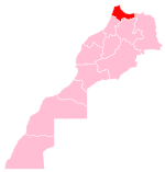
Al Hoceima (Arabic: الحسيمة)[2] is a city in the north of Morocco, on the northern edge of the Rif Mountains and on the Mediterranean coast. It is the capital city of the Al Hoceima Province. The city is a known tourist destination despite its small size. It has a population of about 56,716, according to the 2014 census.[1]
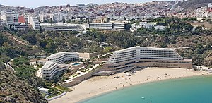
Al Hoceima is distinguished by its pristine sandy beaches such as Cala Iris, Bades, Quemado, and Tala Youssef, as well as its mountainous rocky terrain.
Name
[edit]Al Hoceima is an Arabised version of a Spanish word (Alhucemas – meaning 'Lavenders'), derived from the Andalusi Arabic term 'Al Khazama'."After independence, the Moroccan government established an Arabised name for Alhucemas coming up with Al Hoceima, following the standard French spelling.
History
[edit]Early and colonial history
[edit]The Ait Ouriaghel Berber tribe (also 'Beni Urriaguel') dominated the area around Al Hoceima. Abd el-Krim, whose father was a qadi of the Aith Yusuf clan, organized a guerilla force against the Spanish during the Rif War, establishing the Republic of the Rif in 1921. In September 1925, Spanish General José Sanjurjo landed at Al Hoceima and claimed the territory for Spain. The Spanish developed the town and named it Villa Sanjurjo after General Sanjurjo. The first mayor was Florian Gómez Aroca.
Since Moroccan independence
[edit]
After Morocco gained its independence in 1955, Al Hoceima developed quickly, and the Moroccan government changed its name from the Spanish Villa Alhucemas to Al Hoceima.
The years from 1956 to 1959 were marked by challenges for the Rif region. Morocco's Hassan II, then crown prince, assumed the role of military commander, and during this period, a significant number of people lost their lives in the Rif.[citation needed] In October 1958, the Beni Urriaguel community rebelled against the central administration, prompting the deployment of two-thirds of Morocco's army, led by Hassan, to Al Hoceima.[3]
In the early 1950s and 1960s, during a period of economic hardship when many of the city's inhabitants were of modest means, the small houses in the city were predominantly painted white and blue. These colors, symbolizing the sea and sky, were commonly regarded as the city's official colors. As economic conditions improved over time, residents began to paint their houses in a wider range of colors.
The city and surrounding villages were hit by two large earthquakes within ten years. The first (Mw 6.0 event occurred on May 26, 1994,[citation needed] and the second event (Mw 6.4) occurred on February 24, 2004,[4] killing more than 560 people (see 2004 Al Hoceima earthquake). In 2007, Al Hoceima's mayor stated that all new houses would be painted white and blue in an effort to restore the city's traditional appearance.
Al Hoceima is now a moderate-size city with a population of 56,716 recorded in the 2014 Moroccan census.[1] It has the second-largest port of the Rif region (Nador being the largest). The first schools built by the Spanish colonials, (a college and an elementary school) and a Spanish catholic church, still exist today.
Playa Quemado, where General Sanjurjo and his troops landed in 1925, is one of Al Hoceima's well-known beaches. Situated beneath the Mohammed V hotel, the beach is frequented by visitors. The hotel offers amenities such as a tennis court, restaurant, cocktail bar, and nightclub.
Al Hoceima has been the centre of repression by and political protest against the Moroccan government in the 21st century. Five young protesters were murdered, and their burned bodies found in Al Hoceima, in 2011.[5] On October 28, 2016, a fish-seller, Mouhcine Fikri, was crushed to death in a rubbish truck while trying to retrieve fish confiscated by the authorities,[6] which led to large anti-government protests in November 2016 known as Hirak Rif.[7] Protests in Al Hoceima continued after the start of Ramadan, 26 May, and culminated on 26 June with "bloody clashes",[5] then spreading to other parts of northern Morocco and the country.[6] On 7 January 2023, A 5.3 Magnitude Earthquake hit Al Hoceima Province, Nekkour.[8][9] On 12 February 2023, National Institute of Geophysics announced two earthquakes that occurred in the Al Hoceima region, in the north of the country, measuring 3.8 and 4.3 degrees.[10][11][12]
Climate
[edit]| Climate data for Al Hoceima (Cherif Al Idrissi Airport) (1991–2020 normals, extremes 1965–present) | |||||||||||||
|---|---|---|---|---|---|---|---|---|---|---|---|---|---|
| Month | Jan | Feb | Mar | Apr | May | Jun | Jul | Aug | Sep | Oct | Nov | Dec | Year |
| Record high °C (°F) | 30.0 (86.0) | 30.0 (86.0) | 30.8 (87.4) | 32.6 (90.7) | 34.2 (93.6) | 39.6 (103.3) | 41.0 (105.8) | 38.6 (101.5) | 41.0 (105.8) | 34.6 (94.3) | 35.0 (95.0) | 31.0 (87.8) | 41.0 (105.8) |
| Mean daily maximum °C (°F) | 17.4 (63.3) | 17.7 (63.9) | 19.1 (66.4) | 20.5 (68.9) | 22.9 (73.2) | 25.7 (78.3) | 28.3 (82.9) | 28.9 (84.0) | 26.5 (79.7) | 23.7 (74.7) | 20.5 (68.9) | 18.4 (65.1) | 22.5 (72.5) |
| Daily mean °C (°F) | 12.7 (54.9) | 13.2 (55.8) | 14.7 (58.5) | 16.2 (61.2) | 18.7 (65.7) | 21.7 (71.1) | 24.4 (75.9) | 24.9 (76.8) | 22.6 (72.7) | 19.6 (67.3) | 16.0 (60.8) | 13.7 (56.7) | 18.2 (64.8) |
| Mean daily minimum °C (°F) | 7.9 (46.2) | 8.6 (47.5) | 10.2 (50.4) | 11.8 (53.2) | 14.6 (58.3) | 17.7 (63.9) | 20.1 (68.2) | 20.9 (69.6) | 18.6 (65.5) | 15.5 (59.9) | 11.5 (52.7) | 9.0 (48.2) | 13.9 (57.0) |
| Record low °C (°F) | −1.0 (30.2) | 0.0 (32.0) | 0.0 (32.0) | 0.5 (32.9) | 6.0 (42.8) | 9.0 (48.2) | 11.3 (52.3) | 11.2 (52.2) | 10.0 (50.0) | 6.0 (42.8) | 3.5 (38.3) | 0.0 (32.0) | −1.0 (30.2) |
| Average precipitation mm (inches) | 45.7 (1.80) | 43.6 (1.72) | 37.0 (1.46) | 33.3 (1.31) | 21.1 (0.83) | 9.4 (0.37) | 1.7 (0.07) | 5.2 (0.20) | 14.6 (0.57) | 43.7 (1.72) | 45.8 (1.80) | 34.3 (1.35) | 335.4 (13.20) |
| Average precipitation days (≥ 1.0 mm) | 5.0 | 4.9 | 4.8 | 4.4 | 3.2 | 0.9 | 0.4 | 0.8 | 2.3 | 3.9 | 4.6 | 4.7 | 39.9 |
| Mean monthly sunshine hours | 198.0 | 186.1 | 221.4 | 238.8 | 261.0 | 289.0 | 303.1 | 275.2 | 235.1 | 213.5 | 186.2 | 181.9 | 2,789.3 |
| Source 1: NOAA (sun 1981–2010)[13][14] | |||||||||||||
| Source 2: Meteo Climat (records)[15] | |||||||||||||
Economy
[edit]The city's income is based on fishing and tourism. Many of its former inhabitants migrated to Europe during the 1960s through 1980s; large numbers of Moroccans in the Netherlands, France and Belgium were Al Hoceima natives,[16] many of whom return to Al Hoceima during the summer, when the town is also frequented by tourists from Germany and France.[3]
The town beach is Plage Quemado, which is also where fishers bring in their catch. A quieter beach is in nearby Asfiha. The Torres de Alcala and Kalah Iris beaches are also considered Al Hoceima beaches, though they are 60 km from town.[3]
Transport
[edit]The city is served by the Cherif Al Idrissi Airport.
Education
[edit]There is a Spanish international school, Instituto Español Melchor de Jovellanos.
Abdelmalek Essaâdi University - Campus of Al Hoceima contains:
Faculty of Science and Technology - FST
National School of Applied Sciences - ENSA'H
Multidisciplinary Faculty - FPH (Under Construction)
National School of Commerce and Management - ENCG (Under Construction)
Notable people
[edit]- Nasser Zefzafi, Moroccan political activist
- Jamal Ben Saddik, Moroccan kickboxer
- Tarik Elyounoussi, Norwegian footballer of Moroccan origins.
- Mohamed Elyounoussi, Norwegian footballer of Moroccan origins.
- Ibrahim Afellay, Dutch Former footballer of Moroccan origins.
- Khalid Boulahrouz, Dutch Former footballer of Moroccan origins.
- Isam Bachiri, Danish Singer of Moroccan origins
- Mohamed Oulhaj, Moroccan footballer
- Ilyas El Omari, Moroccan politician
- Youssaf El Marnissi, Moroccan racing driver
Twin towns – sister cities
[edit] Nice, France
 Tuzla, Bosnia and Herzegovina
 Almería, Spain
 Almuñécar, Spain
 The Hague, Netherlands
 Meppel, Netherlands
 Schaerbeek, Belgium
 Sint-Niklaas, Belgium
See also
[edit]References
[edit]- ^ a b c "POPULATION LÉGALE DES RÉGIONS, PROVINCES, PRÉFECTURES, MUNICIPALITÉS, ARRONDISSEMENTS ET COMMUNES DU ROYAUME D'APRÈS LES RÉSULTATS DU RGPH 2014" (in Arabic and French). High Commission for Planning, Morocco. 8 April 2015. Retrieved 29 September 2017.
- ^ "Historique d'Al Hoceima (History of Alhoceima)". Archived from the original on 2018-02-26. Retrieved 2018-04-17.
- ^ a b c Ellingham, Mark (2001). The Rough Guide to Morocco. Rough Guides. pp. 138–39, 150–53. ISBN 9781858286013.
- ^ Oliveira, Carlos Sousa; Roca, Antoni; Goula, Xavier, eds. (2007). Assessing and Managing Earthquake Risk: Geo-scientific and Engineering Knowledge for Earthquake Risk Mitigation: developments, tools, techniques. Geotechnical, Geological and Earthquake Engineering. Vol. 2. Springer Science & Business Media. p. 51. ISBN 9781402036088.
- ^ a b Aidi, Hisham (13 July 2017). "Is Morocco Headed Toward Insurrection?". The Nation. Retrieved 17 October 2020.
- ^ a b "Morocco's unrest is worsening". The Economist. 6 July 2017. Retrieved 8 July 2017.
- ^ "Morocco arrests 11 over fish-seller's death in Al-Hoceima". BBC. November 1, 2016. Retrieved November 3, 2016.
- ^ Sahnouni, Mariya. "5.3 Magnitude Earthquake Hits Morocco's Al Hoceima Province". moroccoworldnews. Retrieved 2023-01-27.
- ^ "5.3 Magnitude Earthquake Hits Morocco's Al Hoceima Province". www.qna.org.qa. Retrieved 2023-01-27.
- ^ "The National Institute of Geophysics in Morocco: two earthquakes in the Al Hoceima region, in the north of the country, measuring 3.8 and 4.3 degrees". dearborn.org. Retrieved 2023-02-12.
- ^ "Earthquake of 4.3 hits Al Hoceima province this morning". HESPRESS English - Morocco News. 2023-02-12. Retrieved 2023-02-12.
- ^ Aamari, Oussama. "4.3 Magnitude Earthquake Hits Morocco's Al Hoceima Province". moroccoworldnews. Retrieved 2023-02-12.
- ^ "Al Hoceima Normals 1991–2020". National Oceanic and Atmospheric Administration. Archived from the original on 4 October 2023. Retrieved 4 October 2023.
- ^ "World Meteorological Organization Climate Normals for 1981–2010". National Oceanic and Atmospheric Administration. Archived from the original on 10 November 2021. Retrieved 10 November 2021.
- ^ "Station Al Hoceima". Meteo Climat. Retrieved 4 October 2023.
- ^ de Haas, Hein (April 2005). "Morocco's migration transition: trends, determinants and future scenarios" (PDF). Global Commission on International Migration. Global Migration Perspectives No 28. p. 12. Retrieved 9 July 2024.
External links
[edit]- Nador Rif News; www.ariffino.net
- Al Hoceima Photos (La page Facebook)
- Al Hoceima Photos (English)
- City Of Alhoceima Website (English)
- Galerie Al Hoceima (FR)
- (in French) Alhoceima, la perle de la Méditerranée'
- (in French) Www. Alhoceima.info Portal de información de la ciudad de Alhoceima'
- Top things to do in Al Hoceima[permanent dead link]


