Annen

Annen | |
|---|---|
 De Wolden | |
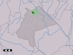
 The village centre (dark green) and the statistical district (light green) of Annen in the municipality of Aa en Hunze. | |
| Coordinates: 53°3′31″N 6°43′6″E / 53.05861°N 6.71833°E | |
| Country | Netherlands |
| Province | Drenthe |
| Municipality | Aa en Hunze |
| Area | |
| • Total | 14.78 km2 (5.71 sq mi) |
| Elevation | 8 m (26 ft) |
| Population (2021)[1] | |
| • Total | 3,595 |
| • Density | 240/km2 (630/sq mi) |
| Time zone | UTC+1 (CET) |
| • Summer (DST) | UTC+2 (CEST) |
| Postal code | 9468[1] |
| Dialing code | 0592 |
Annen is a village in the Dutch province of Drenthe. Located in the municipality of Aa en Hunze, it lies about 12 km (7.4 mi) northeast of Assen.
History
[edit]The village was first mentioned in 1309 as Anne. The etymology is unknown.[3] Annen is an esdorp without a church which developed in the Early Middle Ages on the Hondsrug. It was a large triangular brink (village square) in the south-western corner of the village.[4]
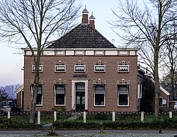
The town hall of the municipality of Anloo used to be located in Annen.[5] It is a wide neoclassic building from 1895 which also contained the residential home of the mayor.[4]
Annen was home to 419 people in 1840.[6] The Reformed Church was built in 1954. It was decommissioned in 1980, and now serves as village house and is used by the local veterinarian.[6] It was an independent municipality until 1998 when it was merged into Aa en Hunze.[6]
Transportation
[edit]The nearest railway station is Assen station. The following bus services stop in Annen: 58, 59, 93 and 318.
Gallery
[edit]- Former school
- Farms in Annen
References
[edit]- ^ a b c "Kerncijfers wijken en buurten 2021". Central Bureau of Statistics. Retrieved 10 April 2022.
- ^ "Postcodetool for 9468AA". Actueel Hoogtebestand Nederland (in Dutch). Het Waterschapshuis. Retrieved 10 April 2022.
- ^ "Annen - (geografische naam)". Etymologiebank (in Dutch). Retrieved 10 April 2022.
- ^ a b Ronald Stenvert (2001). Annen (in Dutch). Zwolle: Waanders. p. 61. ISBN 90 400 9454 3. Retrieved 10 April 2022.
- ^ "Anloo". Plaatsengids (in Dutch). Retrieved 10 April 2022.
- ^ a b c "Annen". Plaatsengids (in Dutch). Retrieved 10 April 2022.


